weather.com meteorologists
Published: January 13, 2021
The halfway point of meteorological winter is Friday, Jan. 15, and while that might seem like the light at the end of the tunnel for those tired of snow and cold, many cities still average more than half their season's snowfall after this date.
Winter in meteorological record-keeping is from Dec. 1 to Feb. 28. But for some parts of the nation, snowy conditions are still possible deep into March and even April.
We've compiled a list showing how much of the season's snow typically remains after Jan. 15 for several cities across the United States based on the 30-year average (1981-2010) from the National Weather Service.
SPONSORED: New year, new sale on Gravity Blankets
In each of the 15 cities we examined from the West to the Midwest and in the Northeast, anywhere from 37 to 71% of the season's average snow falls after the midpoint of meteorological winter. The average for those 15 select cities was 58%.
Interestingly enough, the cities analyzed that have the highest percentage of seasonal snowfall after Jan. 15 are Philadelphia, New York City and Washington, D.C.
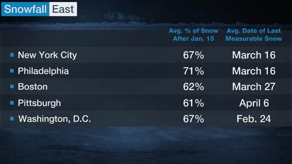 Average percent of seasonal snow remaining after Jan. 15 for select cities in the eastern states.
In Philadelphia, 71% (15.5 inches) of the season's snow typically falls after meteorological winter's halfway mark, while 67% of the season's snow is observed after Jan. 15 in a typical year in the Big Apple (16.9 inches) and the nation's capital (10.3 inches). Farther north, in Boston, 62% (26.8 inches) of its seasonal snow falls after Jan. 15 in an average year.
This is due in large part to the propensity for major Northeast snowstorms in late January, February and March.
The five central and midwestern U.S. cities we examined typically receive 48 to 61% of their average seasonal snow after the halfway mark of meteorological winter.
In both Minneapolis and Detroit, that translates to more than 2 feet of snow after Jan. 15 in an average year.
Chicago averages just under 2 feet of snow after Jan. 15, while Indianapolis can expect a little over a foot of additional snowfall in the second half of a typical winter.
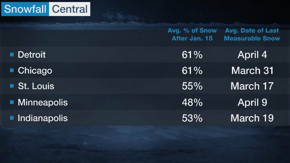 Average percent of seasonal snow remaining after Jan. 15 for select cities in the central states.
In the Pacific Northwest, Spokane, Washington, generally receives the majority of its snowfall in the front half of the winter, with only 37% of its seasonal snow remaining after Jan. 15.
The season is almost a 50-50 split in Salt Lake City, where 49% of its snow falls after Jan. 15.
Tahoe City, California, is one location that can receive snowfall well into the spring; an average season there has more than 100 inches of additional snow after meteorological winter's midpoint.
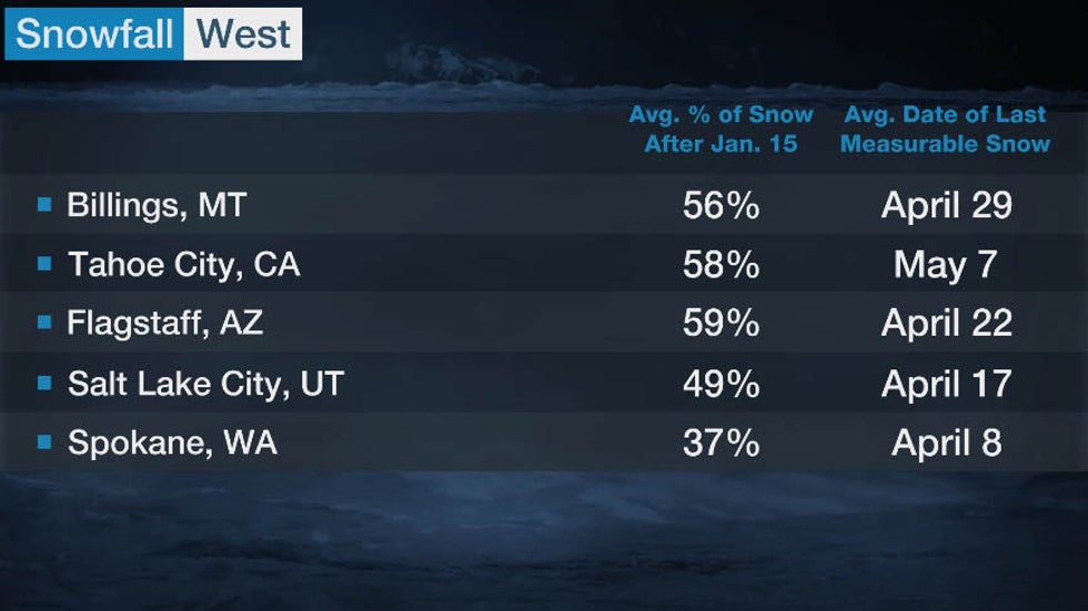 Average percent of seasonal snow remaining after Jan. 15 for select cities in the western states.
So while meteorological winter is technically halfway over on the calendar, Mother Nature doesn't follow the strict dates of the seasons, allowing snow to fall well into early spring
How Much Snow Has Fallen So Far?
The map below shows how much snow has fallen across the Lower 48 through Jan. 12.
Winter Storm Gail in mid-December produced a large amount of the snowfall that portions of the Northeast have seen so far this season.
Season-to-date snowfall totals through Jan. 12 in Boston and New York City are a couple of inches above average because of Gail. Binghamton, New York, picked up nearly half of its average seasonal snow during that storm, which means the city has a surplus of 22 inches at this point in winter.
There is a disparity among snowfall totals for some cities in the central U.S., mostly due to where significant winter storms have tracked.
For example, snowfall in Minneapolis-St. Paul as of Jan. 12 was nearly 4 inches above average for that date. Bismarck in neighboring North Dakota is the opposite with a snowfall deficit of more than 16 inches.
Some cities in the Southern Plains have had more snow this season than parts of the Great Lakes.
Oklahoma City (11.9 inches) and Abilene, Texas (8.7 inches), have picked up more snowfall through Jan. 12 than Chicago (5.4 inches), Milwaukee (8.6 inches) and Grand Rapids, Michigan (7.5 inches). The snowfall total in Grand Rapids is nearly 30 inches below average for this point in the season.
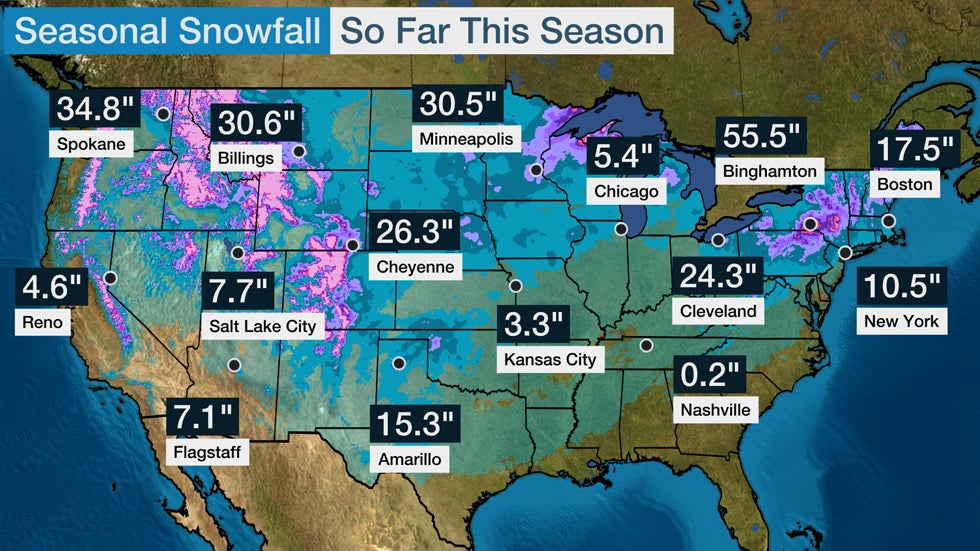
In the West, snowpack from California's Sierra Nevada into Utah's Wasatch and the central and southern Rockies is running well below average in many areas. Salt Lake City had a seasonal snowfall deficit of nearly 20 inches as of Jan. 12. Flagstaff, Arizona's snowfall deficit is even worse at this point in the season at more than 30 inches below average.
Parts of the Northwest have fared better this season with snowpack near or even above average in the Washington Cascades and the far northern Rockies.
The Weather Company’s primary journalistic mission is to report on breaking weather news, the environment and the importance of science to our lives. This story does not necessarily represent the position of our parent company, IBM.
The Weather Company’s primary journalistic mission is to report on breaking weather news, the environment and the importance of science to our lives. This story does not necessarily represent the position of our parent company, IBM.


No comments:
Post a Comment