Chris Dolce
An atmospheric river is poised to take aim at California by midweek with drenching rains that could trigger debris flows and flooding while feet of snow pile up in the Sierra Nevada.
A pattern change late last week opened the door for an active storm track to bring much-needed rain and mountain snowfall to California and other parts of the Southwest. Two weather systems have impacted the region over the last few days, but neither produced widespread, heavy rainfall given their cold origin from the North Pacific.
That will change by midweek when a new low-pressure system approaches the Golden State. What this storm will have that its predecessors did not is a thin, long plume of moisture in the atmosphere that stretches from the Pacific Ocean subtropics called an atmospheric river.
These plumes of moisture can bring heavier rainfall when they set up in California's wet season from late fall through early spring, and that's what we expect to happen this week.
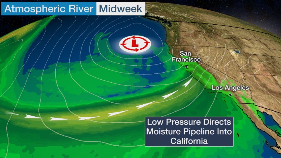
While California needs rain and snowpack to combat an ongoing drought in much of the state, this could be a case of too much of a good thing. That's because the heavy rain might contribute to flooding and debris flows in parts of the state this week.
Recent burn areas from the record-breaking 2020 wildfires in California are of greatest concern at this time. However, some flooding and debris flows could occur outside these charred areas.
Here's what to expect.
Forecast
Flood Threat
The greatest rainfall totals from this event will be in coastal parts of Northern and Central California, which is where the atmospheric river moisture plume is expected to be most persistent late Tuesday through Thursday. This includes locations from around the Bay Area southward to Big Sur and parts of San Luis Obispo and Santa Barbara counties.
Rainfall totals in elevated locations along this stretch of the coast could be 5 to 8 inches (locally higher). Lower elevations may pick up 3 or more inches of rain.
Soaking rain from this system will eventually pivot southward toward the Los Angeles and San Diego areas late in the week.
 Rain and Snow Forecast
Flash flood watches have been issued by the National Weather Service (NWS) from the northern Bay Area southward to south of Monterey from Tuesday afternoon into Thursday afternoon.
In that flood watch, the NWS said there is a "high confidence that thresholds for debris flows will be met for the following 2020 burn scars: Meyers, Walbridge, Glass, Hennessey, Woodward, CZU Lightning Complex, Carmel/River and Dolan".
Evacuation warnings have been issued for some residents in Santa Cruz County because of the debris flow threat. This means individuals in the affected areas must be "prepared to leave immediately", Cal Fire said.
Burn areas farther south into Southern California are also at risk and could be placed under flash flood watches later this week.
 Flood Alerts
Strong Winds
This storm system will pack strong winds for a time when it roars inland late Tuesday through Wednesday.
High wind watches have been issued by the NWS for this threat from the Sacramento Valley to portions of the Bay Area southward to around Big Sur. Stronger wind gusts might contribute to some power outages and tree damage in these regions.
 Wind Alerts
Snowfall
This storm's winter side will unleash heavy snowfall measured by the yardstick in the Sierra Nevada through Friday.
Elevations above 4,500 feet in the northern Sierra could pick up at least 7 feet of snow this week, according to the NWS.
Significant snow will fall well into the foothills of the Sierra since preexisting cold air is in place ahead of this storm. Even the northern Sacramento Valley near Redding could see snowfall when this system first arrives later Tuesday into early Wednesday.
Although this snowpack is beneficial for California's water supply and ski areas, it will also be hazardous to travel.
Travel will be snarled at times by the snow in the Sierra later Tuesday through late week, including Insterstate 80 through Donner Pass. The heavy, wet snow might also contribute to some tree damage and power outages
 Snowfall Forecast
The Weather Company’s primary journalistic mission is to report on breaking weather news, the environment and the importance of science to our lives. This story does not necessarily represent the position of our parent company, IBM.
The Weather Company’s primary journalistic mission is to report on breaking weather news, the environment and the importance of science to our lives. This story does not necessarily represent the position of our parent company, IBM.


No comments:
Post a Comment