Linda Lam
Snowfall started off strong in October, but the pace has not kept up through November and the beginning of December, which has led to some surprising areas that are lacking.
North America's October snow cover was the most since records began in 1967, according to David Robinson from the Rutgers University Global Snow Lab. Snow fell as far south as parts of Texas.
(MORE: Where This Season's Snowfall Started Off Strong)
As expected, the greatest amount of snowfall so far this season has fallen throughout the Rockies, Cascades and into parts of the upper Midwest, northern New York and northern New England.
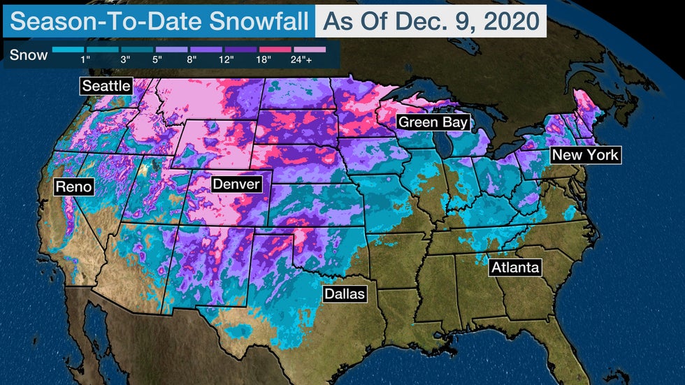 Estimated snowfall so far this season from July 1 through Dec. 9.
However, the expansive snowfall did not persist into November. Warmer-than-average temperatures dominated the weather pattern for much of the U.S. in November, which limited snowfall.
As a result, there are several locations in the West, Midwest and Northeast that have seen notably less snowfall than a usual season so far. Some of these locations can be spotted on the above map.
The lack-of-snow pattern has continued into the beginning of December. Just over 11% of the Lower 48 was covered in snow on Dec. 10, the lowest for the date since 2015, based on data from the NOHRSC.
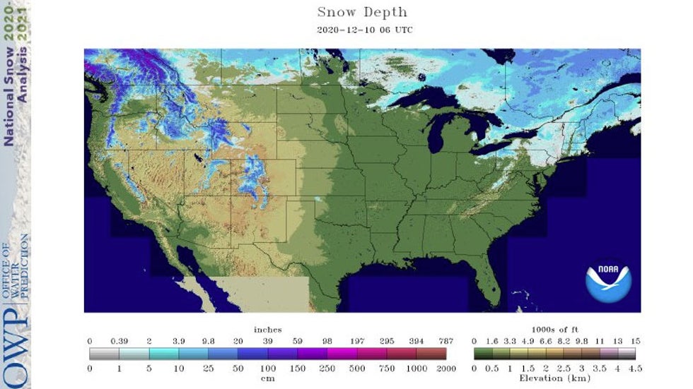 Snow depth on the morning of Dec. 10, 2020.
Below, we take a closer look at some surprising snowfall deficits in the Lower 48 and if there is any snow ahead.
Plains, Midwest and Northeast 'Snow-Nots'
Although it has snowed in the Northern Plains this year, many areas have seen less snow than average so far this season.
In North Dakota, Bismarck and Grand Forks are both about 8 to 9 inches below average. Mild temperatures have been prevalent throughout this area recently and both cities experienced temperatures more than 4 degrees warmer than average for November. That warmer-than-average trend has prevailed for the first nine days of December.
It's a similar story farther east in Wisconsin and much of Michigan, where temperatures have also been relatively mild. Areas from Madison, Wisconsin, to Milwaukee and Green Bay have seen less than half of their average snowfall to date.
Grand Rapids, Michigan – prone to lake-effect snowbands off Lake Michigan – has yet to tally 1 inch of snow this season, one of their least snowy starts to the season on record and one foot below their average season pace through Dec. 9.
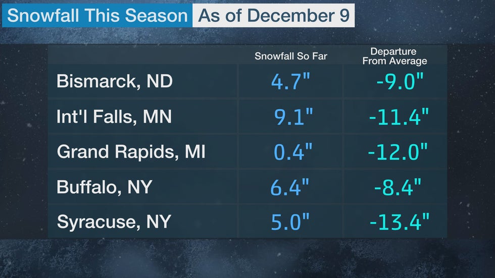
Much of upstate New York and New England are also experiencing snowfall deficits. In western New York, seasonal snowfall is more than 50% below average, including Rochester, which has measured just 5.5 inches, compared to the average-to-date of 12.7 inches.
Areas from Albany, New York, to Burlington, Vermont, have also received less snow than is typically expected by this time of year.
West 'Snow-Nots'
Parts of the Pacific Northwest have enjoyed plentiful snowfall to start the season, but other areas of the West have not been as lucky.
There has been a dearth of snowfall so far this season, especially in Utah, Wyoming, Colorado, Arizona and New Mexico. Snow water equivalent across most of those locations is less than 70% of average, with numerous locations reporting less than half of their snow water equivalent so far.
Cities from Casper, Wyoming, to Salt Lake City to Flagstaff, Arizona, have all seen a notable lack of snowfall so far this season. Flagstaff has picked up just over 4 inches through Dec. 9, one-quarter of their average-to-date of 16.8 inches.
The Four Corners region is also experiencing widespread extreme and exceptional drought, according to the U.S. Drought Monitor. Snowfall over the winter would be beneficial in alleviating drought conditions, but the current pattern has not been conducive to moisture reaching the region.
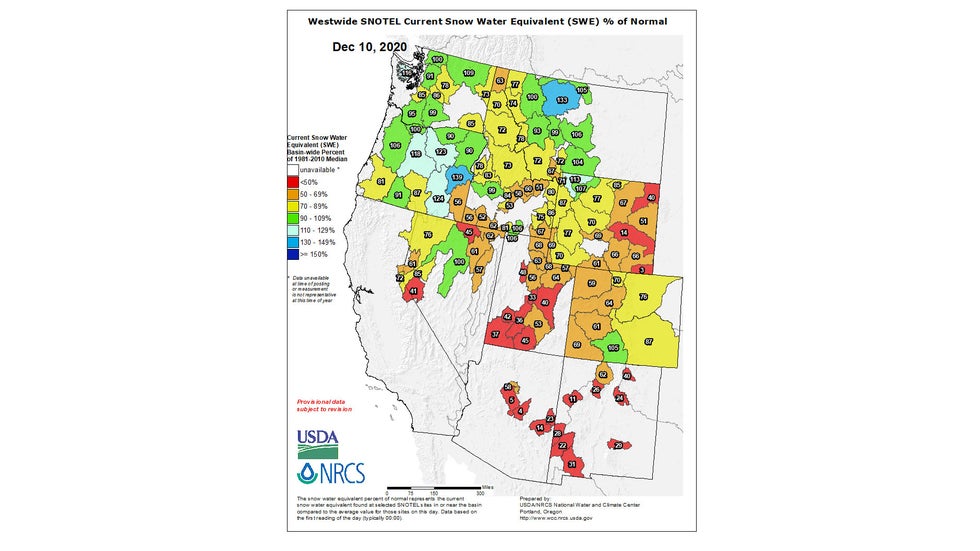 Status of the snowpack in the West, shown as a percentage of average water content of snow, as of Dec. 10, 2020. Areas in red, orange and yellow are below average, while areas in blue are above average for the date.
Snow Ahead For Some
Snow is anticipated into this weekend from parts of the Rockies into the Central Plains and parts of the Great Lakes. This upcoming snowfall will help to reduce deficits in some areas.
Additional snowfall is possible in parts of the Plains and East next week. Portions of the Northwest and the northern and central Rockies are also likely to add more snow in the week ahead.
However, heading into the second half of December, a milder-than-average pattern will likely return, which may limit snowfall in lower elevations. Much of the Lower 48 has at least a 50% chance of above-average temperatures beginning late next week, according to NOAA's Climate Prediction Center.
The Weather Company’s primary journalistic mission is to report on breaking weather news, the environment and the importance of science to our lives. This story does not necessarily represent the position of our parent company, IBM.
The Weather Company’s primary journalistic mission is to report on breaking weather news, the environment and the importance of science to our lives. This story does not necessarily represent the position of our parent company, IBM.


No comments:
Post a Comment