Linda Lam
Severe thunderstorms and heavy rainfall will spread across portions of the South through New Year's Day.
Low pressure will develop over the western Gulf Coast by early Thursday. From there, it will tap into Gulf of Mexico moisture as it tracks toward the Great Lakes and Northeast by early Saturday.
(MORE: Wintry Weather Expected Across the Central, Eastern U.S. New Year's Week)
This setup will result in widespread rain and thunderstorms sweeping across the South through Friday.
There has already been one tornado spawned.
Late Wednesday morning, a short-lived tornado damaged mobile homes and snapped trees in Corsicana, Texas, about 60 miles south-southeast of Dallas. No injuries were reported, according to the Navarro County Office of Emergency Management.
Below, we take a closer look at where severe thunderstorms and flooding rainfall could be concerns.
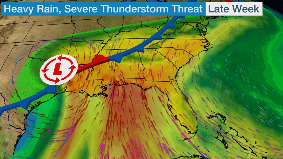 A low-pressure system will track across the central and eastern U.S. late this week as moisture from the Gulf of Mexico streams northward.
Severe Thunderstorm, Flooding Rain Forecast
On Thursday (New Year's Eve), the chance of severe thunderstorms packing damaging winds and some tornadoes will increase near the Gulf Coast.
This threat could start early in the day in southeast Texas and southwest Louisiana. From there, severe storms may spread into Louisiana, Mississippi, southwest Alabama and the western Florida Panhandle by late afternoon and evening.
 Thursday-Thursday Night Severe Thunderstorm Forecast
The threat of a few severe thunderstorms might persist into New Year's Day in the Southeast.
Isolated damaging wind gusts could accompany stronger thunderstorms from northern Florida into southern North Carolina. There is a chance of an isolated tornado, but overall, that threat is low at this time.
 Friday-Friday Night Severe Thunderstorm Forecast
The highest rainfall totals from this storm system through Friday are expected from northeastern Texas into Arkansas and southeastern Oklahoma. Many locations could get more than 3 inches of rainfall through New Year's Eve.
Some of this rainfall will be welcomed, especially in the Southern Plains, as drought conditions persist throughout most of Texas and southern Oklahoma. But too much rain too fast could also trigger flash flooding in some areas.
Flash flood watches have been issued by the National Weather Service from northeast Texas to southeast Oklahoma southwest and central Arkansas.
Localized flash flooding is possible in other parts of the South as heavy rainfall pushes across the region into New Year's Day.
Given the threat of severe weather and flooding this holiday week, make sure you have a way to receive weather warnings, especially if you are traveling.
 Rain Forecast
The Weather Company’s primary journalistic mission is to report on breaking weather news, the environment and the importance of science to our lives. This story does not necessarily represent the position of our parent company, IBM.
The Weather Company’s primary journalistic mission is to report on breaking weather news, the environment and the importance of science to our lives. This story does not necessarily represent the position of our parent company, IBM.


No comments:
Post a Comment