weather.com meteorologists
Eta will spend most of the rest of the week over Central America, producing potentially catastrophic rainfall flooding, but a second chapter to this storm that could be of more concern to the United States is increasingly likely to unfold this weekend and into early next week once the system, or its remnants, emerges back over the Caribbean Sea.
Until that happens, and several other forecast particulars come into focus, there's not much that can be said about the details of any tropical threat to the U.S.
So the key takeaway is that parts of the Caribbean and the southern United States should keep an eye on Eta's forecast over the coming days for answers.
Here are the details of what we know, and what to look out for, to determine the final future of Eta.
What We Know
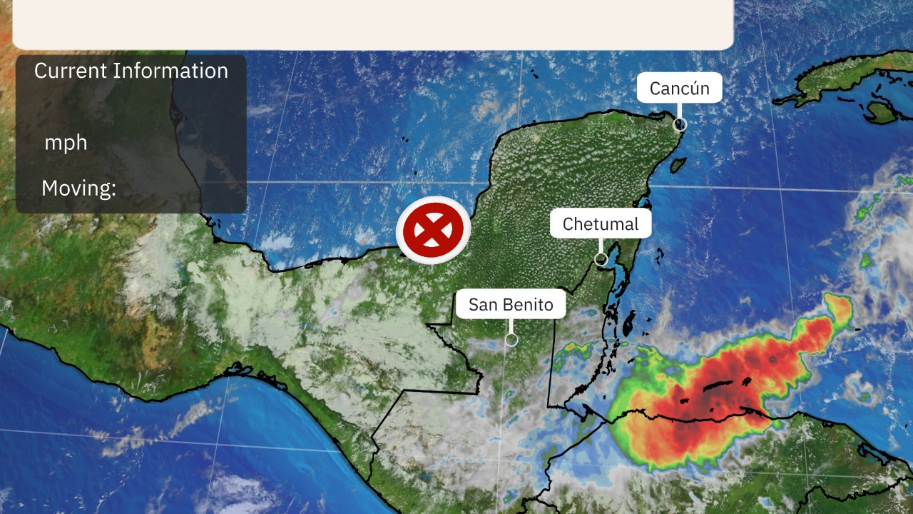
Eta will move slowly west-northwest across Central America through Friday and could even dissipate for a time.
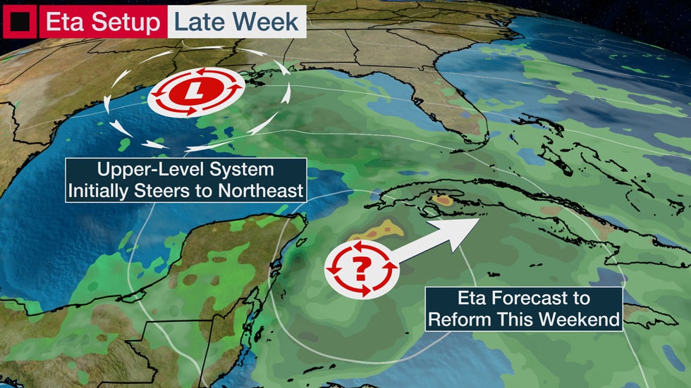
But its remnant spin and energy are expected to emerge over the northwest Caribbean Sea by this weekend. That's when Eta could reorganize into a tropical depression or storm, as depicted in the latest forecast below from the National Hurricane Center.
Eta will be steered north and northeast initially once it moves back over the northwest Caribbean beginning late this week or early in the weekend. That's because Eta will be pushed in that direction by the interaction with the counterclockwise flow around an upper-level low-pressure system located in the Gulf of Mexico, as seen in the graphic below.
Parts of the Cayman Islands and Cuba could see heavy rain this weekend if this setup pans out as forecast.
That takes us to what we don't know yet about Eta's long-term future.
What We Don't Know
One unknown right now is how long that upper low will last to impact Eta.
The longer it lasts, the farther north Eta could be pulled this weekend, potentially into the Florida Peninsula as a tropical storm.
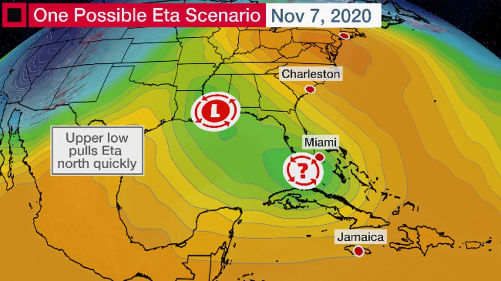 One possible scenario for Eta involves a stronger, longer-lasting Gulf of Mexico upper low that pulls Eta farther north and faster this weekend.
Alternatively, that upper low could weaken faster, allowing an upper-level high-pressure system over the eastern states to take over as Eta's steering wheel.
This clockwise flow around this building high could block Eta's northeast or northward movement, or even turn it in a more westerly direction for a time into the eastern Gulf of Mexico.
If that happens, Eta could make a final landfall somewhere along the eastern Gulf Coast later next week.
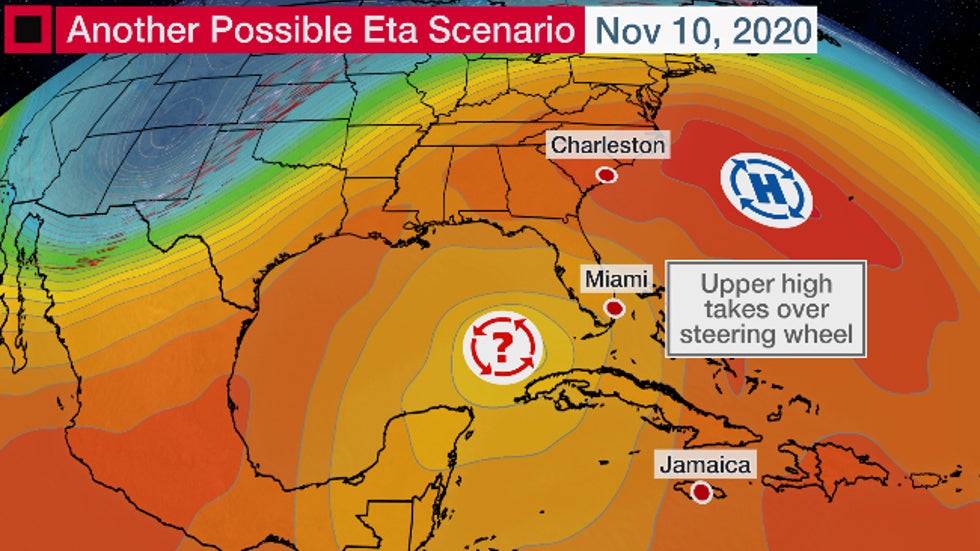 Another possible scenario for Eta involves a weaker Gulf of Mexico upper low giving way to eastern U.S. high pressure that steers Eta into the Gulf of Mexico next week.
The bottom line is that interests in the northwest Caribbean, Florida, and even parts of the U.S. Gulf Coast, should monitor the progress of Eta and its forecast. Think of this just as an early heads up. There is nothing to be overly concerned about at this time since there are so many forecast details that need to be ironed out before Eta can even come close to being labeled as a threat to the U.S.
Eta's forecast has the potential to be a long-lived story that lasts well into next week, so there's plenty of days ahead to keep watching how the forecast unfolds.
No matter what eventually happens, parts of the Florida Peninsula could at least see some bands of heavy rain associated with Eta's moisture as soon as this weekend that could lead to local flash flooding.
 Rainfall Forecast
Furthermore, the gradient between high pressure in the eastern U.S. and Eta's lower pressure in the Caribbean should contribute to gusty winds blowing onshore along Florida's East Coast from the second half of this week into the weekend and early next week. That will allow high surf and dangerous rip currents to increase from Florida's East Coast to possibly as far north as South Carolina.
The Weather Company’s primary journalistic mission is to report on breaking weather news, the environment and the importance of science to our lives. This story does not necessarily represent the position of our parent company, IBM.
The Weather Company’s primary journalistic mission is to report on breaking weather news, the environment and the importance of science to our lives. This story does not necessarily represent the position of our parent company, IBM.


No comments:
Post a Comment