Jonathan Belles
We have finally reached the end of the historic 2020 Atlantic hurricane season.
It was one of the most active hurricane seasons on record and nearly every community in the coastal United States experienced a tropical storm or hurricane in some form. Much of the Caribbean, Bermuda and even Portugal also experienced tropical systems in 2020.
The back-loaded season produced at least twice as many tropical storms, hurricanes and major hurricanes as an average season, including nine cyclones with a Greek name.
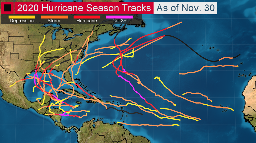 Tracks for the 2020 Atlantic Hurricane Season
Here's a look back at some of the season's most memorable moments:
1. The 28th Storm is Named, Then Two More Form
The 2005 Atlantic hurricane season set records that were unthinkable in the century that preceded it, but 2005 was taken down in nearly every way in 2020.
So many storms were named that the secondary Greek name list had to be used just a week after the peak of hurricane season. This was only the second time on record the Greek name list was used. The other was 2005.
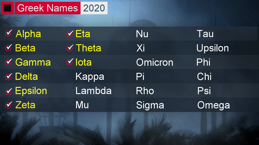 Greek names used in 2020.
After going Greek, the season whizzed through nine more names by the end of hurricane season, or three deeper into the hurricane name depth chart than in the 2005 season, since one 2005 storm was unnamed, found in post-season analysis.
The season ended with 30 named storms (record), 13 hurricanes and six major hurricanes including five Category 4 hurricanes (record).
2. Portions of Louisiana Ended Up in Multiple Cones
Louisiana took the hurricane season on the chin. One notable example of this came during several days in late August when southern Louisiana found itself in the cones of uncertainty for both Marco and Laura.
More than three-quarters of the Pelican State was in both cones on Aug. 22.
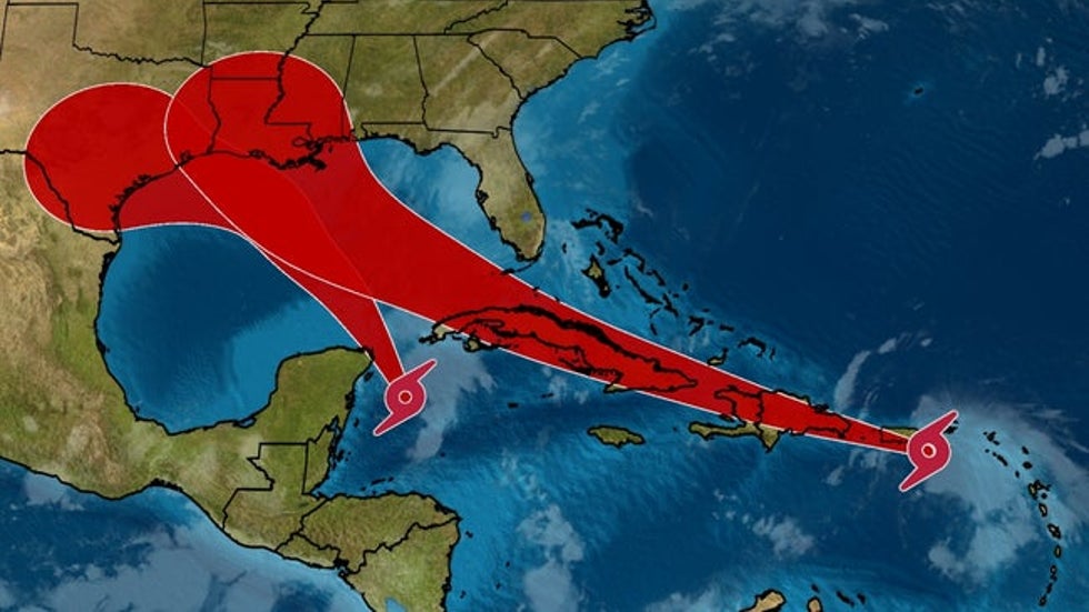 The cones from tropical storms Marco (left) and Laura (right) on Aug. 22.
Multiple tropical systems have to be in relatively close proximity in order for this to happen, and that doesn’t happen often in the Atlantic.
But Louisiana wasn’t just in two cones this year. It spent three weeks total in cones of uncertainty from Cristobal, Laura, Marco, Sally, Beta, Delta and Zeta, according to NOAA scientist Sam Lillo.
3. Hurricane Laura Punched Through Southwestern Louisiana
Hurricane Laura was the first of many notable and deadly hurricanes this season.
Despite striking nearly every island in the Greater Antilles, Laura rapidly intensified in the Gulf of Mexico from a tropical storm to a Category 4 hurricane before making landfall near Cameron, Louisiana, at 1 a.m. CDT, Aug. 27, with 150 mph winds.
Laura’s landfall was one of the strongest in the U.S. and was the strongest storm to make landfall in Louisiana.
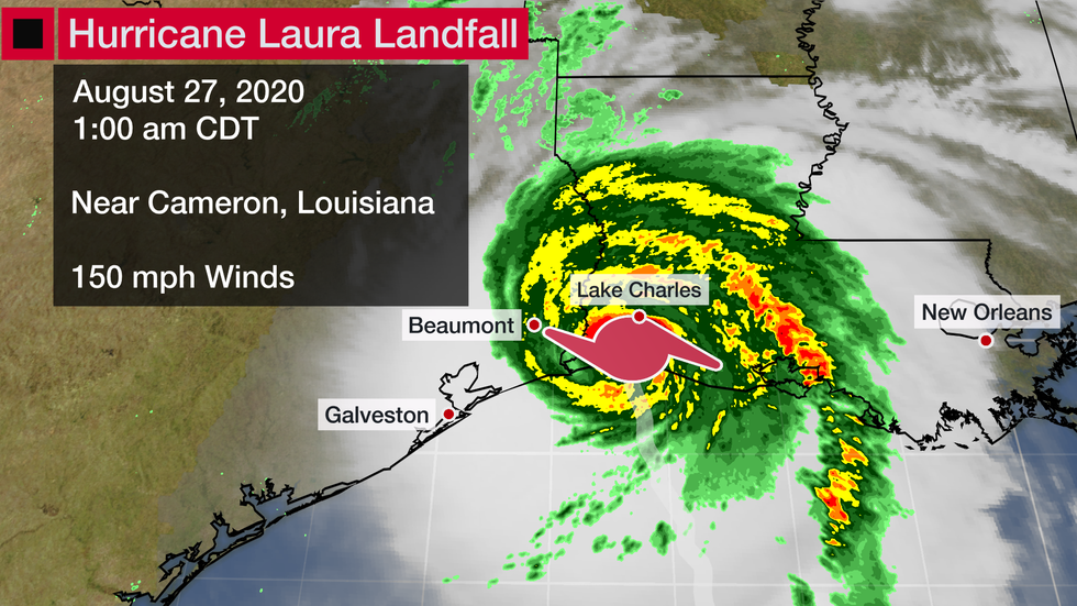
It hurled more than 15 feet of storm surge miles inland in step with 100 mph wind gusts and heavy rain. The surge wiped homes from their foundations near the Gulf of Mexico and the wind took off roofs as far north as Interstate 10. Catastrophic damage was found across Cameron and Calcasieu parishes.
Laura knocked out power to 900,000 customers and destroyed the electrical grid across southwestern Louisiana. Electrical repairs alone will likely cost more than $1.25 billion in Louisiana and Texas.
Strong winds also obliterated the Lake Charles radar, a radar that was unfortunately needed just weeks later for Beta and Delta.
Laura killed 42 people and caused $14 billion in damage in the United States.
4. Nearly Every Storm is the Earliest on Record
Among the many records set during the 2020 hurricane season, this one popped up more frequently than any other.
Of the record 30 named storms this season, 27 of them were the earliest formation for their respective number.
Arthur, Bertha and Dolly are the only storms that did not have a record-early formation date.
Of course, some of these earliest formations were because of the record-breaking number of storms. Theta and Iota were the first 29th and 30th storms of any season.
The frenetic pace in September, which featured 10 named storms, also contributed to this record. July and November also had record-tying numbers of storms for their respective months.
5. Seven Tropical Systems at Once in Mid-September
Mid-September is usually the busiest time of the year for the tropical Atlantic, but this season had forecasters from the National Hurricane Center crying uncle.
On the morning of Sept. 14, there were two hurricanes, two tropical storms, one tropical depression and two tropical disturbances.
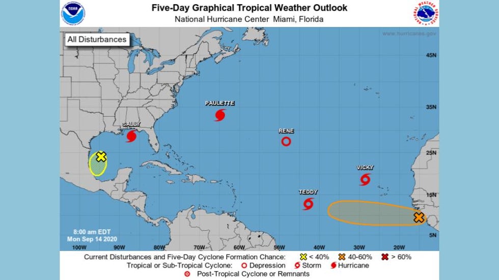
The combined five tropical cyclones at the same time tied September 1971 for the most on record at once in the Atlantic, according to Eric Blake, a senior hurricane scientist at the National Hurricane Center.
Three of these systems went on to make landfall: Paulette in Bermuda, Sally in Alabama and Teddy in Nova Scotia.
6. The Hurricane Center Names Three Storms in Six Hours
Wilfred, Alpha, and Beta became named systems within a six-hour span on Sept. 18. It was only the second time on record (1893) that three systems formed in a single calendar day.
A tropical depression in the Gulf of Mexico was expected to become Tropical Storm Wilfred, but instead, another disturbance in the eastern Atlantic Ocean took that name late that morning. Wilfred was quickly followed by Subtropical Storm Alpha's development just prior to landfall in Portugal.
Finally, at 4 p.m. CDT, that tropical depression in the Gulf gained enough strength to be become Tropical Storm Beta. The storm would go on to make landfall in Texas.
This frenetic moment happened less than a week after the seven tropical systems at once mentioned in the last moment. Ten tropical storms were named in total in September.
7. Ten Storms Undergo Rapid Intensification
The winds in three of this year’s named storms – Iota, Delta and Eta – intensified by at least 100 mph in 36 hours or less.
In all, 10 of this year's named storms underwent rapid intensification: at least a 35 mph increase of maximum sustained winds in 24 hours or less.
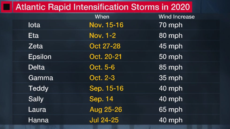 List of storms that rapidly intensified in the 2020 Atlantic hurricane season, along with peak 24-hour wind intensification rates.
(MORE: This Season's Rapid Intensification History)
Most of these rapid intensifiers occurred once the hurricane season went Greek.
8. Two Hurricanes Cause 5 Million-Plus People to Lose Power
Several landfalling storms knocked out power to more than 5 million people this year.
The first storm, Hurricane Isaías, ripped up the East Coast in early August. Strong winds from the storm knocked out power from the Carolinas to New England, according to PowerOutage.us. In some spots outages lasted for more than a week. The New York City metro area, New Jersey and Connecticut were particularly hard hit.
Isaías also knocked out power in Puerto Rico in late July before making landfall in eastern North Carolina on Aug. 4.
At the end of October, Hurricane Zeta made landfall in southeastern Louisiana, then went on to knock out power to more than 2.6 million customers from Louisiana to the western Carolinas.
The New Orleans and Atlanta metro areas were particularly hard hit by damaging winds, which downed thousands of trees. Power restoration took several days in these areas.
Hurricanes Laura and Delta also knocked out power to significant portions of Louisiana, but the total number of outages was lessened by lower population density. More than a dozen people were killed, directly or indirectly (generators used to power air conditioners produced carbon monoxide) by heat following Hurricane Laura.
9. Central America Suffers Two Category 4 Landfalls in Less than Two Weeks
In the span of 13 days, Category 4 hurricanes Eta and Iota made landfall on Nicaragua's Caribbean coast just 15 miles apart from each other.
These two hurricanes caused massive flooding, extreme wind damage and storm surge in Nicaragua, Honduras and Colombia's outlying islands. Flooding also occurred in parts of Panama, Costa Rica, El Salvador and Belize.
Hundreds of thousands of people were displaced, and millions in Central America were impacted at least once, according to the Associated Press. Many were affected twice, especially in Nicaragua.
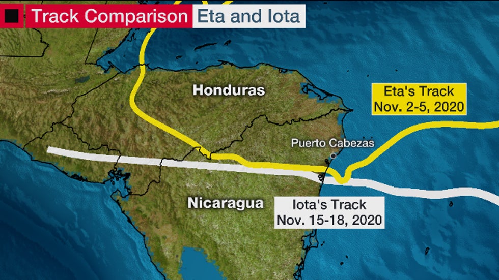
Colombia's island of Providencia, which lies off the Nicaraguan coast, suffered a catastrophic blow during Iota's passage near the island as a rare November Category 5 hurricane. Colombian President Ivan Duque said 98% of the island's infrastructure was "affected," according to the Associated Press.
While the death toll remains unclear, it is likely that many people died as a result of these two storms in Central America alone.
10. Retired Greek Names For the First Time Ever?
The Greek-named storms were arguably the worst of the season.
Of the nine Greek-named storms, five became major hurricanes. Most of these storms caused fatalities and three of them are likely to have caused billions of dollars in damage.
It is extraordinarily likely that some of these storms, including Eta and Iota, will have to be retired for the first time ever.
Storm names are typically retired "if a storm is so deadly or costly that the future use of its name on a different storm would be inappropriate for obvious reasons of sensitivity," according to the National Hurricane Center.
Storm names that have been retired in the past include Katrina, Harvey and Sandy.
But a committee of the World Meteorological Organization (WMO) responsible for tropical cyclone names around the world doesn't fully retire a Greek name.
The WMO says that if a Greek storm name is worthy of retirement it's done so with the year attached to it, but that the Greek name can be used again in a subsequent year.
For instance, if Eta is retired, the next time it comes around, it will still be called Eta while this year's retired version of Eta will be called "Eta 2020" in the record books.
We'll have to wait until spring 2021 to see if any of the Greek named storms are retired, but it seems like a solid bet.
The Weather Company’s primary journalistic mission is to report on breaking weather news, the environment and the importance of science to our lives. This story does not necessarily represent the position of our parent company, IBM.
The Weather Company’s primary journalistic mission is to report on breaking weather news, the environment and the importance of science to our lives. This story does not necessarily represent the position of our parent company, IBM.


No comments:
Post a Comment