Linda Lam and Chris Dolce
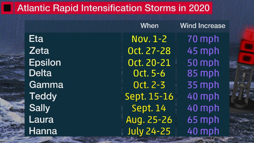
Hurricane Eta rapidly intensified on Monday, becoming the ninth storm this season to do so in the Atlantic Basin, and research suggests this could become more common as the world warms from climate change.
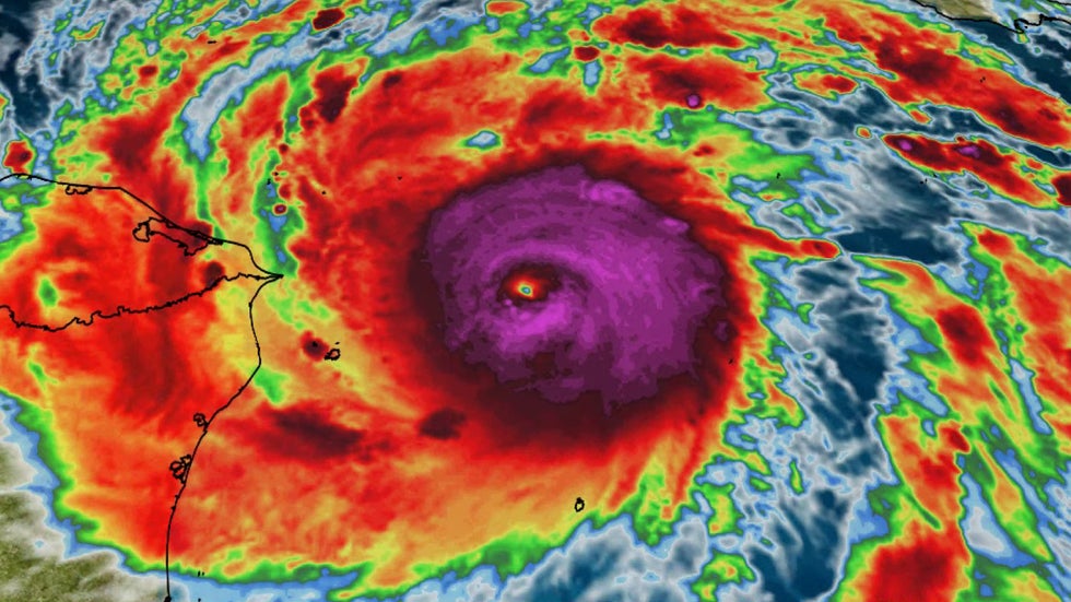
Maximum sustained winds in Eta increased by 70 mph in the 24 hours ending 10 a.m. EST Monday. That's double the meteorological criteria for the rapid intensification of a tropical cyclone, which a wind speed increase of 35 mph or more in 24 hours or less.
 Satellite view of Eta on Monday morning when it rapidly intensified.
The 2020 Atlantic hurricane season now has one of the highest numbers of rapidly-intensifying storms for a single year in recent decades.
Only one other Atlantic season, 1995 with 10, has had more storms rapidly intensify in a single Atlantic season since 1979, according to a tweet from Tomer Burg, an atmospheric science Ph.D. student at the University of Oklahoma. Three other years have had as many as nine storms rapidly intensify.
Including Eta, the Atlantic basin has now had five consecutive storms that have rapidly intensified since early October.
All but one of the nine systems that achieved rapid intensification this year became a hurricane. Only Gamma remained a tropical storm. Its peak maximum sustained winds reached 70 mph, just shy of hurricane status.

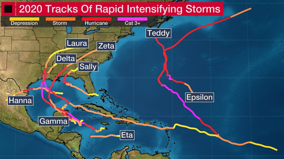
Conditions in the Gulf of Mexico and Caribbean have been generally favorable for tropical cyclones and seven of the rapid intensifications occurred in this part of the Atlantic basin: Hanna, Laura, Sally, Gamma, Delta, Zeta and Eta. The other two storms, Teddy and Epsilon, had their burst of rapid strengthening in the central Atlantic.
Extreme hurricane intensification rates could increase in the future from climate change, according to recent research from Kerry Emanuel, an MIT hurricane scientist.
Emanuel's research suggests climate change will tilt the odds toward more frequent cases of extreme rapid intensification before landfall.
By 2100, the chance of a hurricane's winds increasing by 70 mph or greater in 24 hours right before landfall is expected to be once every 5 to 10 years, according to Emanuel. That's an increase from a rate of once every 100 years in the late-20th-century climate.
 Tracks of tropical cyclone that have rapidly intensified in the Atlantic Basin in 2020, as of Nov. 2.
Other Notable Rapid Intensifications
Hurricane Delta was particularly noteworthy since it set a record for the fastest strengthening from a tropical depression to a Category 4 hurricane in the Atlantic Basin. It did so in just over 36 hours from Oct. 4 to Oct. 6.
Winds in Delta increased by 85 mph, more than double the criteria mentioned above for rapid intensification, in the 24 hours ending 11:20 a.m. EDT, Oct. 6.
(MORE: Hurricane Delta's Record Rapidly Intensification)
Hurricane Sally underwent a particularly quick intensification. Sally's maximum sustained winds increased by 40 mph in just 12 hours on Sept. 14. Hurricane Sally did not become a major hurricane (Category 3 or higher) and made landfall near Gulf Shores, Alabama, as a Category 2.
Hurricanes Laura, Teddy and Delta all reached major hurricane status.
Unsurprisingly, this year's strongest Atlantic hurricane, Laura, also rapidly intensified. Hurricane Laura had maximum sustained winds of 150 mph (Category 4) when it made landfall in southwestern Louisiana on Aug. 27.
(MORE: Hurricane Laura's Rapid Intensification in Satellite Images)
 Satellite images of Hurricane Laura rapidly intensifying as it moved across the Gulf of Mexico in August 2020.
The Weather Company’s primary journalistic mission is to report on breaking weather news, the environment and the importance of science to our lives. This story does not necessarily represent the position of our parent company, IBM.
The Weather Company’s primary journalistic mission is to report on breaking weather news, the environment and the importance of science to our lives. This story does not necessarily represent the position of our parent company, IBM.

No comments:
Post a Comment