Jonathan Erdman
The 2020 Atlantic hurricane season is one for the history books.
We ran out of storm names and had to resort to the Greek alphabet for only the second time. A record 10 storms made a U.S. landfall.
But the hyperactivity overshadowed many other weird happenings during the season.
It was a challenge, but we narrowed the list down to 15, ranking them based on how remarkable each one was.
15. Isaias' Worst Impact Was Well After Landfall
While Isaias (ees-ah-EE-ahs) did produce damaging storm surge and winds in North Carolina when it moved ashore as a Category 1 hurricane on August 3, an unusually strong early August jet stream grabbed the storm and whipped it through the Northeast, producing widespread damaging winds.
Numerous trees were downed - some on vehicles and homes - from Virginia to New England. Over 5 million homes and businesses lost power from North Carolina to New England, according to poweroutage.us.
Isaias also spawned at least 30 tornadoes, including a record long-track tornado for Delaware.
(FULL RECAP: Hurricane Isaias)
 New York City Mayor Bill de Blasio talks with residents about damage from Tropical Storm Isaias, Tuesday, Aug. 4, 2020, in the Queens borough of New York.
14. Sally Turned Outside the Cone
Hurricane Sally provided a textbook example of what a forecast cone means and why monitoring for changes in a forecast is important.
On September 13, the forecast cone for Sally was centered on southeast Louisiana, with its easternmost edge on the Alabama Gulf Coast.
Sally then slowed to a crawl. Like many slow-moving tropical cyclones, it became a challenge to forecast exactly when and, thus, where it would take a northward turn toward the Gulf Coast.
Between September 13 and 16, the forecast cone gradually trended farther east.
Sally ended up making landfall near Gulf Shores, Alabama, on September 16, which was outside the forecast cone issued three days prior to landfall.
A forecast cone is simply where the NHC expects the center of a tropical storm or hurricane to track. Some of the most destructive impacts from Sally were in the Florida Panhandle, also outside the September 13 forecast cone.
(FULL RECAP: Hurricane Sally)
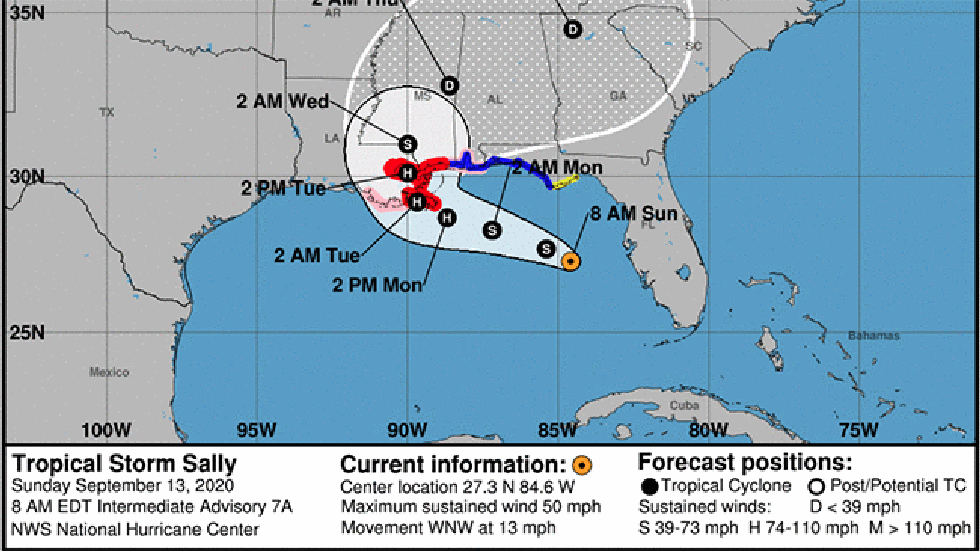 National Hurricane Center forecast cones for Hurricane Sally from September 13-16, 2020, show the progressively eastward trend in the forecast until Sally's landfall along the Alabama Gulf Coast.
13. 10 Landfalls, But None in Florida
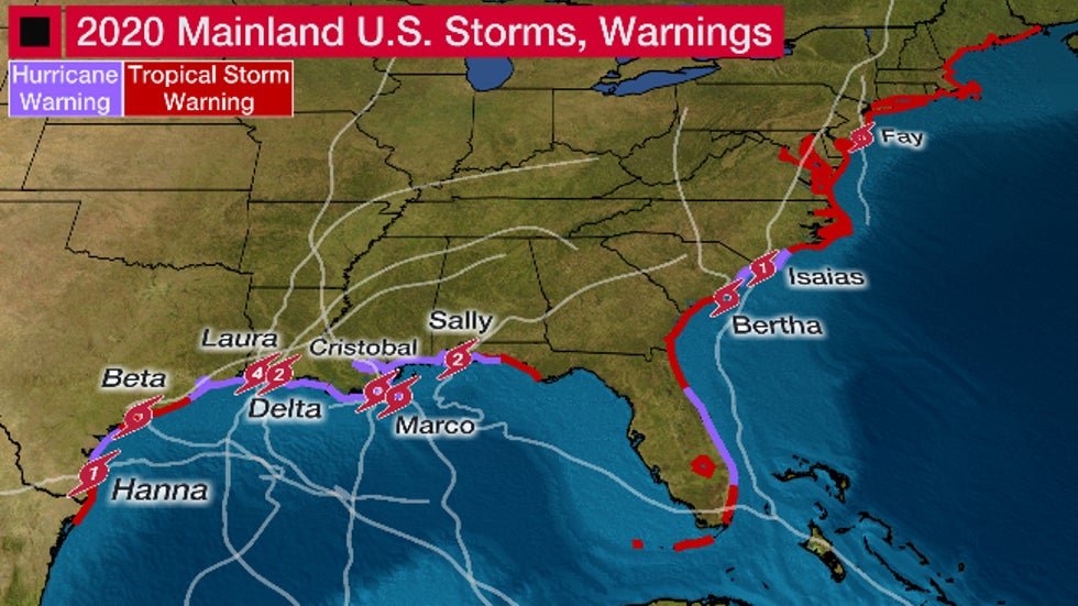
With 26 named storms, 10 of which made landfall as of the time of this column, one would guess Florida took it on the chin this hurricane season.
Incredibly, not one of those landfalls occurred in Florida.
That's not to say parts of Florida weren't impacted, though.
Hurricane Sally officially made landfall at Gulf Shores, Alabama, but hammered the Florida Panhandle after first moving across South Florida as a tropical depression.
Isaias was the only other storm to come close. It teased Florida's Atlantic coast but remained offshore.
(MORE: Florida Shrugs Off Frenetic 2020 Hurricane Season, With One Exception)
 Tracks and landfall locations of 10 tropical storms and hurricanes that made a mainland U.S. landfall in 2020. Coastal areas in red (purple) show extent of tropical storm (hurricane) warnings issued during the season.
12. Bertha Landfalls One Hour After Forming
Bertha, we hardly knew you.
On May 27, Tropical Storm Bertha formed about 30 miles offshore of Charleston, South Carolina.
One hour later, it made landfall. By late that night, it had lost its tropical characteristics west of Greensboro, North Carolina.
Bertha soaked parts of the Carolinas into Virginia and the Appalachians. However, it produced much heavier rain over South Florida the day before as a tropical disturbance.
 Track history of Tropical Storm Bertha in late May 2020.
11. Thickest Saharan Dust in 17 Years Makes It to Omaha
Intrusions of Saharan dust are common across the tropics early in the hurricane season.
But in late June, one of the most extreme Saharan dust outbreaks since at least 2003 surged westward across the tropics.
And it didn't stay in the tropics.
Over the last weekend of June, Saharan dust pushed into parts of the nation's heartland, including Omaha, Nebraska, leading to hazy skies and poorer air quality.
10. Major Flooding 3 Days in a Row From a Distant Hurricane
Hurricane Teddy was a large hurricane that passed east of Bermuda, then struck Atlantic Canada as a post-tropical cyclone in mid-September.
It may have been over 1,000 miles away, but as most central Atlantic hurricanes tend to do, Teddy generated large swells that reached the East Coast.
Storm tides at Charleston, South Carolina's Cooper River tidal gauge reached major flood stage three days in a row from Sept. 19-21, the first time it had done so three straight days in records dating to 1934.
This led to widespread flooding in the city's historic downtown and other areas near the South Carolina coast.
9. Second NWS Radar in Three Years Shredded By Hurricane
The local National Weather Service radar was another casualty of Hurricane Laura's destructive winds in Lake Charles, Louisiana.
Winds in the northern eyewall of Laura blew away the radar's white radome, an enclosure resembling a large golf ball that was built to withstand Category 4 winds and meant to protect the radar's antenna.
A wind gust to 133 mph was measured by the automated wind instrument at the airport a little less than an hour after the radar transmitted its last image. Since the radome was atop a 65-foot tall tower, it's likely the radome experienced higher gusts.
This was the second time in three years an NWS radar was destroyed by a hurricane.
Hurricane Maria destroyed the NWS radar in Cayey, Puerto Rico, in Sept. 2017. That radar was rebuilt the following summer.
8. Hurricane Hunter Plane Struck By Lightning
A seemingly routine Hurricane Hunter mission in early October had to be aborted due to weather.
Shortly after taking off from Keesler AFB in Biloxi, Mississippi, on the morning of Oct. 2, the aircraft was struck by lightning south of the Louisiana coast.
Lightning strikes on aircraft aren't rare. They typically happen once a year somewhere over the Earth. A plane's skin is made of a material that essentially conducts electricity off the plane.
In the Hurricane Hunters case, however, the strike knocked out its radar, vital for onboard meteorologists to see what they're flying into.
So, instead of investigating Tropical Depression Twenty-Five (later to become Gamma), the crew had to turn around and head back to Biloxi.
7. Paulette's Eye Engulfs Bermuda, Then 'Zombie Paulette'
Bermuda covers less than 21 square miles in the vast North Atlantic Ocean.
On September 14, the 35- to 40-mile-wide eye of Hurricane Paulette completely engulfed the archipelago while it was a Category 1 hurricane. The Bermuda Weather Service conducted a Facebook live showing the radar depiction while the eye was overhead.
That wasn't the only weird thing about Paulette.
After becoming a post-tropical cyclone east-southeast of Newfoundland on September 16, Paulette came back to life six days later as a tropical storm south of the Azores in the far eastern Atlantic Ocean.
While this "Zombie Paulette" phase only lasted 24 hours, its remnant low was still evident on satellite imagery into early October.
6. Cristobal Made It to the Upper Midwest
"Upper Midwest" and "tropical cyclone" don't usually go together.
But in early June, Tropical Depression Cristobal pushed north up the Mississippi Valley and made it as far north as outside Dubuque, Iowa, before losing its tropical depression status. It then continued into Wisconsin as a post-tropical cyclone.
Cristobal was only the fourth Atlantic tropical cyclone remnant to reach Wisconsin in more than a century of records, according to the National Weather Service office in Milwaukee.
Cristobal produced thunderstorms with damaging winds in Chicagoland and in Lower Michigan. Its heavy rain triggered flash flooding as far north as southeast Minnesota and northwest Wisconsin.
(MORE: Complete Recap of Tropical Storm Cristobal)
 Radar recap and storm track of Tropical Storm Cristobal from June 6-10, 2020. (Note: In NOAA's Best Track database, Cristobal was no longer considered a tropical depression after it passed near Dubuque, Iowa, on June 9.)
5. Five at Once
Multiple tropical cyclones at one time are a common occurrence, particularly during the heart of hurricane season.
But on September 14, satellite imagery highlighted five separate systems of at least tropical depression strength for only the second time in the satellite era.
Hurricane Paulette over Bermuda and Tropical Storm Sally over the northeast Gulf of Mexico were part of that parade.
Incredibly, there were six systems at once in the Atlantic Basin from Sept. 11-12, 1971.
4. Laura, Then Delta, in Six Weeks
In late August, Hurricane Laura became the first Category 4 hurricane to landfall in southwest Louisiana. It produced storm surge inundation of up to 19 feet along the southwest Louisiana coast and widespread destructive winds in Lake Charles.
Just six weeks later, Hurricane Delta made a Category 2 landfall near Creole, Louisiana, only about 15 miles east of Laura's landfall location.
Delta once again brought high winds to Lake Charles, where many roofs were still covered by tarps after Laura's siege. Up to 9 feet of surge inundation was recorded along the south-central Louisiana coast.
By late October, Lake Charles residents feared they had been forgotten in a year of various other natural disasters, the pandemic, civil unrest and the runup to the elections.
 Tracks of Hurricane Laura and Hurricane Delta over southwest Louisiana in 2020.
3. When Two Cones Crossed
One of the most bizarre forecast scenarios came to fruition well before Laura ever became a hurricane or was anywhere near the mainland U.S.
What would later become Hurricane Marco formed in the western Caribbean Sea one day after Laura first formed in the central Atlantic.
Some computer forecast models at the time suggested Laura and Marco could eventually get close enough to interact with each other in a weird circular dance known as the Fujiwhara effect. Some even suggested there could be two Gulf of Mexico landfalls almost simultaneously.
The forecast eventually evolved to suggest Marco would first take aim on the Gulf Coast, followed by Laura, which is what happened. Fortunately, wind shear ripped Marco apart as it neared the northern Gulf Coast, but it still managed to landfall in southeast Louisiana.
It still led to the weird occurrence of two overlapping forecast cones.
2. A Record 10 Storms Made a U.S. Landfall
Ten different storms made a mainland U.S. landfall in 2020.
This topped the previous record of nine U.S. landfalling storms in a hurricane season, a record that stood since 1916.
Five of those were hurricanes at landfall. Typically, only 1 or 2 hurricanes make a U.S. landfall in an average season.
Seven of the 10 landfalling storms did so in the northern or western Gulf of Mexico. Four of those made landfall in Louisiana, which tied 2002 for the most in any season in the Pelican State.
Bertha began the landfall parade in late May. Delta set the record in early October.
Every part of the East Coast and Gulf Coast, except for the western coast of the Florida peninsula, had a tropical storm or hurricane warning this season.
1. Three Storms in Six Hours
One of the strangest days in memory for some tropical meteorologists happened during the most frenetic stretch of the hurricane season.
First Tropical Storm Wilfred formed in the eastern Atlantic Ocean, using up the last name of the 2020 Atlantic hurricane season list of names.
A swirling low was named Subtropical Storm Alpha just two hours later. The Greek alphabet was now being used for only the second time, and the first Greek alphabet named storm was moving into Portugal.
Alpha was so far northeast in the Atlantic Basin only part of its name and symbol plotted on the National Hurricane Center's map.
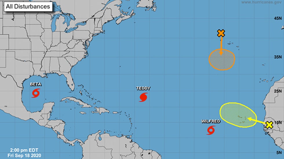 The NHC's outlook map on Sept. 18, 2020, at 2 p.m. EDT. One of the active named storms at the time, Subtropical Storm Alpha, is almost off the map in the upper-right corner, with only the first letter of Alpha – "A" – visible on the map.
But that strange day wasn't done yet.
Later that afternoon, Tropical Depression Twenty-Two in the Gulf of Mexico was upgraded to Tropical Storm Beta.
Three new storms had formed in just six hours.
According to Colorado State University tropical scientist Phil Klotzbach, August 15, 1893, was the only other day in which three Atlantic Basin storms formed on the same calendar day.
The Weather Company’s primary journalistic mission is to report on breaking weather news, the environment and the importance of science to our lives. This story does not necessarily represent the position of our parent company, IBM.
The Weather Company’s primary journalistic mission is to report on breaking weather news, the environment and the importance of science to our lives. This story does not necessarily represent the position of our parent company, IBM.


No comments:
Post a Comment