Jonathan Erdman
A weather pattern change next week may bring modest relief from the recent siege of massive, destructive wildfires and cloak of dense smoke across parts of Washington, Oregon and California.
As of Wednesday, over half of the 96 large wildfires burning in the West were in California, Oregon and Washington, according to the National Interagency Fire Center (NIFC). Malden, Washington, and Phoenix, Oregon, were just two of the towns scorched.
"I've talked to people who have been in fire for 20, 30, 40+ years and they've never seen anything like this before," said NIFC fire meteorologist Nick Nauslar in a tweet Tuesday evening.
(MORE: Tens of Thousands Under Evacuation Orders in California, Washington and Oregon)
Another fast-spreading wildfire prompted evacuation orders in the foothills of the Sierra near Oroville, California, early Wednesday, just east of the town of Paradise, devastated by the November 2018 Camp Fire.
California already set a record for acres burned in any year since the 1970s. CalFire said Tuesday over 2,650 more fires have occurred in California this year compared to last year through September 7.
Strong winds blanketed large parts of California, Oregon and Washington in a dense pall of smoke.
Then as winds tapered off, the lofted smoke particles began falling closer to the ground in some areas, darkening the skies and leading to a surreal, Martian-like view in the San Francisco Bay area Wednesday.
It took an extreme confluence of weather factors to lead to the magnitude of this latest wildfire siege.
Worsening drought in much of the West this summer was punctuated by the hottest August dating to 1895 in California, Nevada, Utah, Arizona, Colorado and New Mexico, according to NOAA.
Over Labor Day weekend, a record strong upper-level high pressure system set up near the West Coast, sending temperatures soaring to all-time record highs in parts of California.
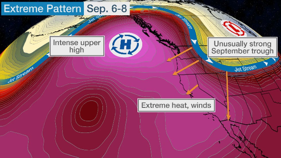
An unusually sharp plunge of the jet stream into the Rockies then whipped up strong, dry offshore winds that turned existing and new fires into fast-spreading firestorms, not to mention wringing out record early-season Rockies snow.
Pattern Change Relief For Some Ahead
While winds are subsiding in most areas, there will still be some persistent heat in the Pacific Northwest the next few days.
After that, there is a little bit of good news. The pattern over the West Coast is about to change next week.
Instead of a massive dome of high pressure diverting the jet stream well to the north, forecast guidance suggests the jet stream will return to the Pacific Northwest by early next week.
This should drive a modest cold front into the Northwest.
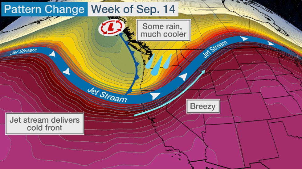
While it won't be much, that should bring the first rain in weeks, if not longer, to the Pacific Northwest.
As usual in this setup, the best chance of rain early next week will be in Washington and Oregon, from the Cascades westward to the coast.
This could be the first 0.1 inch rainfall in both Seattle and Portland, Oregon, in three weeks. Some rain is also possible as far south as Medford, Oregon, where measurable rain, typically a minimum in the summer dry season, hasn't fallen since the week before Father's Day.

Unfortunately for the rest of the West Coast, the news with this pattern change isn't all that great.
Onshore winds ahead of the front will push cooler, more humid marine air to California's coastal areas, keeping any excessive heat at bay. However, rain chances will largely be confined to extreme northwestern California.
Furthermore, gusty winds ahead of the cold front could make fighting existing or new fires a challenge as well.
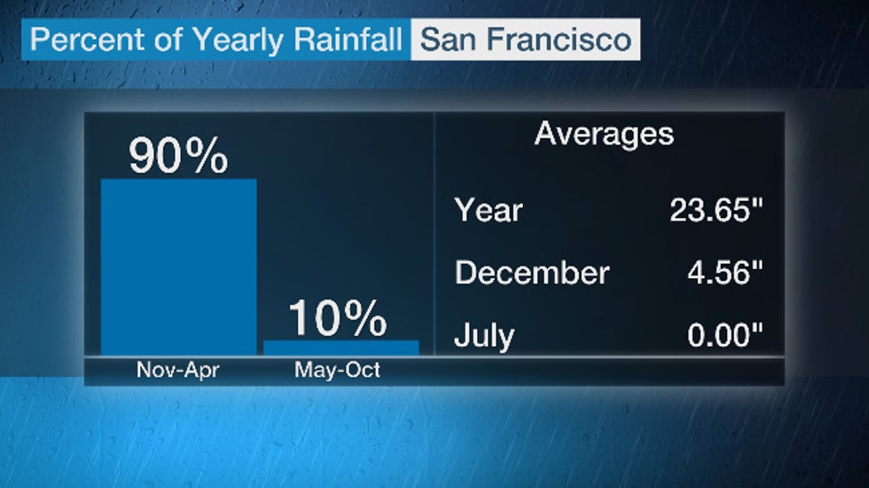
This is typical for September, as the month still lies firmly in California's dry season. Ninety percent of the average annual rain in San Francisco happens from November through April.
 California has distinct wet and dry seasons. September still lies in the dry season.
Unfortunately, this pattern change may not last that long.
Longer-range forecast guidance suggests a trend back toward a hotter and drier pattern is possible by the following week (Sept. 20).
So, for now, any Western fire relief will be subtle, as can be expected in September.
The Weather Company’s primary journalistic mission is to report on breaking weather news, the environment and the importance of science to our lives. This story does not necessarily represent the position of our parent company, IBM.
The Weather Company’s primary journalistic mission is to report on breaking weather news, the environment and the importance of science to our lives. This story does not necessarily represent the position of our parent company, IBM.


No comments:
Post a Comment