Jonathan Erdman
Paulette and Rene are tracking through the Atlantic and there are two other areas in the Atlantic also being watched for the possible formation of a tropical depression this week.
Paulette and Renee
Both Paulette and Rene each set records for the earliest "P" and "R" storms in any Atlantic hurricane season.
The westernmost system, Paulette, is expected to remain at tropical storm strength for the next few days. Its chances for significant intensification are being hindered right now by unfavorable upper-level winds and dry air. However, its wind shear may diminish by this weekend, which could allow it to regain strength.
Paulette is no immediate land threat at this time. However, those in Bermuda should monitor the forecast closely since Paulette could move near the group of islands early next week.
The easternmost storm, Rene, brought locally heavy rainfall and gusty winds to the Cabo Verde Islands Monday into Tuesday.
Rene is moving away from the Cabo Verde Islands and will head northwest and then north into the open central Atlantic Ocean. The system is no further threat to land at this time.
 Forecast Paths
Two Other Atlantic Areas to Watch
There are two other areas in the Atlantic that the National Hurricane Center is monitoring for tropical development. These two areas are labeled in the map below, in addition to Paulette and Rene.
Area #1
The first area is a low-pressure system located several hundred miles east of the Carolinas. Although this system is disorganized, some gradual development into a tropical depression can't be completely ruled out the next couple of days as it moves generally west to west-northwest.
This system could at least enhance rainfall in parts of the mid-Atlantic and Southeast by later this week even if it never becomes better organized.
Area #2
A second system, a tropical wave located over western Africa right now, will emerge into the eastern Atlantic by Thursday.
This system is likely to form into a tropical depression as it tracks westward late this week into the weekend.
It's uncertain what, if any, land areas this system might affect in the long-term future.

Record Early, Again
The 2005 hurricane season previously held the record earliest "P" and "R" storms, Philippe on Sept. 17 and Rita on Sept. 18, respectively.
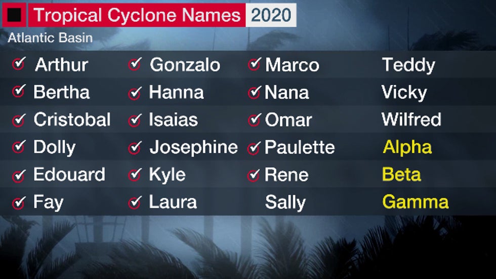
After Rene, only four names are left in the 2020 Atlantic hurricane season names list. Additional storms after "Wilfred" would be named after letters in the Greek alphabet starting with "Alpha". That has happened only once before, in the 2005 hurricane season.
 2020 Atlantic hurricane season names list. Checkmarks show storm names already used through Sept. 7, 2020.
And there's more in store after Rene.
The parade of tropical disturbances moving westward off the African coast known as African easterly waves continues, as usual around the peak of the hurricane season.
One or more of those African waves could develop in the eastern Atlantic Ocean over the next week or so.
The Weather Company’s primary journalistic mission is to report on breaking weather news, the environment and the importance of science to our lives. This story does not necessarily represent the position of our parent company, IBM.
The Weather Company’s primary journalistic mission is to report on breaking weather news, the environment and the importance of science to our lives. This story does not necessarily represent the position of our parent company, IBM.

No comments:
Post a Comment