weather.com meteorologists
Hurricane Sally made landfall early Wednesday morning near the Alabama and Florida border, with catastrophic flooding rainfall, damaging storm surge and strong winds. Sally will pose a threat of flooding rainfall well inland across the Southeast through early Friday.
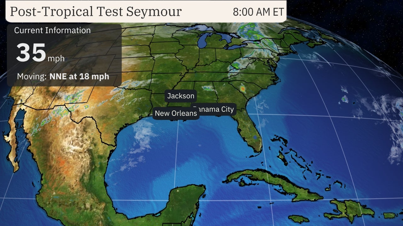
The center of Sally is now well inland after it was downgraded to a tropical storm Wednesday afternoon.
Sally is picking up a little forward speed inland over the Deep South after it made landfall near Gulf Shores, Alabama, at 4:45 a.m. CDT Wednesday as a Category 2 hurricane with maximum sustained winds of 105 mph.
Flooding rainfall and gusty winds continue to pound parts of the Florida Panhandle, Alabama and southwest Georgia.
(LATEST: Sally Brings Damaging Storm Surge and Flooding Rainfall)
 Current Radar and Winds
Storm surge flooding inundated areas where Sally's center crossed the coast, from Alabama to the western Florida Panhandle.
A storm surge of 5.6 feet has been recorded in Pensacola, Florida. Parts of the city's downtown area were submerged by several feet of water because of the storm surge and heavy rainfall. Peak inundations of 3 to 4 feet above normal high tide levels were recorded also in Panama City Beach and Dauphin Island, Alabama.
Serious flash flooding with flooded homes and roads - some sections of which were washed out - has also occurred in numerous spots from southeast Alabama into the Florida Panhandle and southwest Georgia. This torrential rain on top of the storm surge has combined to produce catastrophic flooding near the Gulf Coast.
Flash flood emergencies were issued by the National Weather Service Wednesday in the western Florida Panhandle for parts of Escambia, Okaloosa, Santa Rosa, Walton and Washington Counties. Record flooding was measured on the Shoal River near Mossy Head in Walton County, Florida.
These highest-level flash flood warnings were also issued in southeast Alabama for southeast Baldwin, northern Coffee and northern Dale Counties, where the NWS estimated rainfall rates of 4 to 6 inches in one hour would occur.
The highest measured rainfall total so far is just over 24 inches at Pensacola Naval Air Station. Another estimated rainfall total of 30 inches was also reported near northwest Pensacola.
 Estimated Precipitation
A wind gust to 92 mph was measured early Wednesday morning in Pensacola, Florida. Dauphin Island, Alabama, and Mobile, Alabama have seen wind gusts as high as 99 mph and 82 mph, respectively.
More than 500,000 homes and businesses lost power in Alabama and the Florida Panhandle, according to poweroutage.us.
While not nearly as strong as winds in the hours before or after landfall near the coast, numerous trees were reported down in Montgomery and Pike Counties, Alabama, among other areas.
Forecast
Future Track, Intensity
Sally continues to move northeastward into the Deep South.
The storm will weaken quickly and pick up forward speed as it tracks inland across Alabama and Georgia, then through the Carolinas through early Friday.
 Current Information and Projected Path
Flooding Rainfall
Sally is producing a serious threat of life-threatening flooding rainfall.
Sally's highest rainfall totals, locally up to 35 inches, are expected from extreme southeast Alabama into the Florida Panhandle. NOAA's Weather Prediction Center issued a rare high risk of excessive rainfall for this area on Wednesday.
Heavy rainfall from Sally will trigger flooding farther inland across other parts of southern and central Alabama, Georgia and the Carolinas through early Friday. NOAA's Weather Prediction Center has issued a moderate risk of excessive rainfall from much of Alabama and the Florida Panhandle into Georgia and parts of the western Carolinas Wednesday into Thursday night.
Here is the latest rainfall forecast from the NHC, including what has already fallen.
-Additional rainfall of 1 to 4 inches, with storm totals of up to 35 inches are possible in the Florida Panhandle. Serious flash flooding and moderate to major river flooding is occurring in these areas. More than a half dozen river gauges in this region are forecast to reach major flood stage, according to NOAA.
-4 to 8 inches, with locally up to 12 inches, is possible farther inland across southern Alabama into central Georgia. Significant flash and urban flooding is likely, as well as widespread minor to moderate flooding on some rivers in these areas.
-4 to 7 inches, with locally up to 10 inches, in central and Upstate South Carolina. Widespread flash flooding and urban flooding is possible in these areas. Minor to moderate river flooding could also occur.
-4 to 6 inches, with locally up to 8 inches, in western and central North Carolina into southeast Virginia. Scattered flash flooding and widespread minor river flooding is possible in this area.
 Rainfall Forecast
Flood watches have been issued by the National Weather Service from the Florida Panhandle to southern Virginia.
 Flood Alerts
Tornadoes
Isolated tornadoes are possible through early Thursday morning in parts of northern Florida and southern Georgia.
As Sally moves into Georgia and the Carolinas, some isolated tornadoes are also possible Thursday and Thursday night.

Sally Recap
Sally was born as Tropical Depression Nineteen just off the coast of South Florida on Sept. 11.
The following afternoon the depression strengthened to Tropical Storm Sally over the Gulf of Mexico just off the southwest coast of Florida.
Flooding rainfall soaked parts of the Florida Keys on Sept. 12. Some areas in the Keys picked up nearly a foot of rainfall.
Sally also soaked parts of the western Florida Peninsula on Sept. 13 as it moved northward over the eastern Gulf of Mexico.
Just before noon on Sept. 14, Hurricane Hunter reconnaissance aircraft found Sally had intensified into a hurricane while centered about 165 miles southeast of Biloxi, Mississippi.
Sally then slowed to a crawl, and as with many slow-moving tropical storms and hurricanes, became a challenge to forecast exactly when and, thus, where it would take its northward turn toward the Gulf Coast.
Sally finally developed a small inner core, which allowed it to strengthen to a Category 2 hurricane before making landfall near Gulf Shores, Alabama, on the morning of Sept. 16.
 Sally's Track History
Sally became the eighth tropical cyclone in the 2020 Atlantic hurricane season to make a mainland U.S. landfall, a record number through mid-September, according to Colorado State University tropical scientist Phil Klotzbach.
Sally also made landfall in the exact same location as Category 3 Hurricane Ivan in 2004.
One rather fascinating oddity about Sally was a drop in water levels.
As Sally moved inland on Sept. 16, water levels in Mobile Bay dropped from 3 to 9 feet below normal for a brief time as strong north winds pushed water out of the mouth of Mobile Bay.
The Weather Company’s primary journalistic mission is to report on breaking weather news, the environment and the importance of science to our lives. This story does not necessarily represent the position of our parent company, IBM.
The Weather Company’s primary journalistic mission is to report on breaking weather news, the environment and the importance of science to our lives. This story does not necessarily represent the position of our parent company, IBM.


No comments:
Post a Comment