Wednesday, September 30, 2020

AccuWeather's US winter forecast calls for a two-faced season for millions

 By Brian Lada, AccuWeather meteorologist and staff writer

Published Sep. 30, 2020 12:39 PM


As Americans hunker down to weather the pandemic this winter at home, nearly every facet of life will remain upended to safeguard against the coronavirus. Millions are working from home and learning remotely and even holiday gatherings will look a lot different this year. Staying closer to home may mean fewer weather worries for commutes and disruptions to daily activities, but AccuWeather has you covered on what you can expect weather-wise as we navigate uncertain times.

Accuweather’s team of long-range forecasters, led by Senior Meteorologist Paul Pastelok, released its annual predictions for the upcoming winter season this week. The team has been analyzing global weather patterns and various weather models to project what conditions will unfold across the lower 48 United States this winter, which arrives on Dec. 21 this year. Much of the time the setup will be driven by one key factor: La Niña.

La Niña is a phenomenon in which the surface water near the equator of the Pacific Ocean are cooler than normal, the opposite of El Niño when the water in the equatorial Pacific is in a warm phase. This change in the water temperature can have a major influence on the weather patterns all around the globe. According to NOAA’s Climate Prediction Center, La Niña officially developed by early September and is forecast to continue through the winter months.

The ongoing La Niña is projected to bring weather conditions similar to what meteorologists expect across the country during a typical La Niña pattern, but there may be a few subtle differences, Pastelok said.

Take a look below at a complete region-by-region breakdown:

Northeast, Midwest

The winter of 2019-2020 was tame across much of the northeastern U.S. with only a handful of Arctic outbreaks and very little snow to speak of along the Interstate 95 corridor -- and the upcoming winter could bring some echoes of last winter.

“Another overall mild winter is possible for much of the eastern U.S.," Pastelok said, referring how temperatures will compare to the 30-year averages in many places. However, he expects "near-normal snowfall across much of New England.”

And, it's worth noting, the entire season will not be mild all the way through. Instead, the season will be bookended by cold and snowy conditions with a pause in the wintry weather in the middle of the season.

“An early-season chill is expected in the Great Lakes, Ohio Valley into the Northeast,” Pastelok said.

The first waves of chilly Arctic air will set off rounds of lake-effect snow downwind of the Great Lakes, as well as bring opportunities for snow in some of the bigger cities across the region heading into the holiday season.

“There is a good chance for a white Christmas in Chicago, perhaps around 30-35% chance at this point,” Pastelok said. “For Pittsburgh, much of the lake-effect snow could fall north of the city and it may be tough to keep snow on the ground. But from this far out I give a 15-20% chance for a white Christmas in Pittsburgh, but, still, there is a chance.”

Christmas trees laden with freshly fallen snow are displayed for sale at Boston Hill Farm, Wednesday, Dec. 11, 2019, in North Andover, Mass. (AP Photo/Elise Amendola)

After the calendar flips to 2021, Old Man Winter will eventually loosen his grip on the region.

“A big turn" is expected around the middle of the season as temperatures are predicted to rise and snowfall should decrease, Pastelok said, due in part to the strength and positioning of the polar vortex. More on that later.

But as the Northeast sees a break in the cold and snow, folks across the Great Lakes and Midwest will want to brace for some bitter spells of wintry weather.

There will be a favorable storm track mid-season for the Midwest and Great Lakes, leading to above-normal precipitation and a few heavy snowfalls events, Pastelok explained.

The storm track will eventually shift eastward during the latter part of the season, bringing the potential for some big coastal snowstorms.

A woman shovels a yard during a snowstorm, Thursday, Jan. 4, 2018, in Ocean Grove, N.J. (AP Photo/Julio Cortez)

A period of stormy and snowy weather may occur later in February or March as nor'easters can develop and impact the region, Pastelok cautioned.

Even with the potential for some big snow events, the season as a whole is forecast to finish with near- to- below-average snowfall for much of the Northeast and Ohio Valley. In contrast, the Upper Midwest could pick up near- to- above-normal snowfall. Winter storms could dish out a whopping 55 to 65 inches of snowfall this season in Minneapolis, which sees 54.7 inches of snow on average based on data from 1991 to 2020.

Southeast

The first part of the winter may be the coldest for the southeastern U.S., as a brief shot or two of cold air has the potential to rush down from the north all the way to the Gulf Coast.

“Early cold may take a run at the eastern U.S. if snow lays in the Ohio Valley and parts of the Tennessee Valley in December,” Pastelok said.

Atlanta, Huntsville, Alabama, Greeneville, South Carolina, and Charlotte and Raleigh, North Carolina, could all be hit by a cold snap to kick off the season. Even Floridians may want to make sure to dig out heavier coats from the closet sooner rather than later.

“There is a small chance for an early-season frost in northern and central Florida perhaps impacting the citrus crop,” Pastelok added.

Temperatures are projected to rebound as the season carries on, paving the way for much warmer conditions through the balance of the winter.

“Near-record warmth [is predicted] at times in the Southeast, occasionally extending into the mid-Atlantic,” Pastelok said.

This extended warmth will be good news for restaurants across the region that have added outdoor seating areas due to the coronavirus pandemic, and could perhaps allow them to utilize the extra space even during the winter months.

Restaurants that do have outdoor seating should still keep a close eye on the weather forecast, not just for temperatures, but also for disruptive storms, especially during the first few weeks of 2021.

Empty outdoor seating for a restaurant and closed hotels are shown, Tuesday, Aug. 11, 2020, in Miami Beach, Florida's famed Ocean Drive on South Beach. (AP Photo/Wilfredo Lee)

“Severe thunderstorms may occur more than usual from the central Gulf Coast to the Southeast in late January and February,” Pastelok said.

Storms could not only spoil an outdoor meal but also bring gusty winds that could damage some of the temporary structures that have been constructed to keep patrons safe from the spread of the new coronavirus.

Plains, Rocky Mountains

The central U.S. experienced a taste of winter as soon as autumn arrived. Meteorological fall began on the first day of September, and just one week later, a winter-like storm dove down across the Plains and northern Rockies, causing temperatures to tumble and delivering snow to the Rockies and some of the foothills. Denver saw the temperature go from a high of 93 one day in early September, to a low of 36 and snowfall the next day.

It may have been a shock to the system for people who live from Montana to New Mexico, but it was a preview of what is to come this winter.

“The middle of the nation may go through some big swings in temperatures, [and] dry and active periods,” Pastelok said. “Periods of subzero cold can drive south down the Front Range of the Rockies, the central and western Plains.”

CLICK HERE FOR THE FREE ACCUWEATHER APP

Snow will be a prominent feature during these big swings, especially over the northern Rockies and into parts of Colorado, which will be beneficial for ski resorts across the region.

“Montana, Utah, Wyoming, and especially the west slopes of Colorado can do quite well” in terms of snowfall, Pastelok said.

There is also the chance for some frequent snowfall in the northern Plains in parts of Nebraska, Iowa, North Dakota, South Dakota, and Minnesota.

Farther south, the chances for snow will be lower, including part of the southern Plains, the southern Rockies and westward into the Four Corners.

Meanwhile, the central Plains will be in the battleground zone, swinging from bitterly cold conditions to spells of milder weather and then back again in less than a week’s time.

While skiers in the mountains hope for snow to fall early and often, so too will some farmers across the Plains, especially in Kansas, western Oklahoma, and the Texas Panhandle, a major crop area for winter wheat, according to the USDA.

“If there is a lack of snowpack, this can endanger the winter wheat crop,” Pastelok said.

A lack of snow may compound the drought concerns for farmers across the region that could carry over into next year.

Farther west over the Four Corners and into Nevada where drought conditions are even worse, the lower frequency of storms will translate to longer-term drought issues.

According to the United States Drought Monitor, parts of Utah, Colorado, Arizona, New Mexico, and far western Texas are already enduring extreme drought conditions. Some smaller areas are in the grips of exceptional drought conditions, the worst level of drought highlighted by the drought monitor report. Even in the spring when snow in the mountains melts and helps to fill rivers, a below-average snowpack would leave rivers at lower levels.

West Coast

Autumn may feel shorter this year across the Pacific Northwest as wintry weather makes an early entrance across the region.

“Mountain snow and stormy conditions may arrive in late fall for the Northwest, northern California and northern Rockies,” Pastelok said.

Even the Interstate 5 corridor from Medford, Oregon, through Seattle will have several opportunities for accumulating snowfall, potentially even before 2020 draws to a close.

“It may not just be the Cascades that get hit, but interior Northwest areas, even down through Wasatch Mountains central Rockies and northwest Wyoming as well,” Pastelok added.

The waves of storms throughout the upcoming months will help to ease the drought conditions across the region, especially in Oregon where more than 60% of the state is in severe drought and over 30% is in an extreme drought.

More importantly, the early arrival of winter storms will spell the conclusion to a historic wildfire season that has charred millions of acres across Washington, Oregon and California.

However, after the flames have smoldered, heavy rains could pose an added danger in the burn scars left behind by the fires, especially in the mountainous terrain.

With a lack of healthy vegetation and root systems in place, the charred landscape is more susceptible to flooding and can quickly lead to flash floods and mudslides. In some cases, it can take years for vegetation to become reestablished to bring down the risk of flash flooding near burn scars.

In this photo provided by Santa Barbara County Fire Department, mudflow, boulders, and debris from heavy rain runoff from early Tuesday reached the roof of a single story home in Montecito, Calif., on Wednesday, Jan. 10, 2018. A storm caused deadly mudslides in fire-scarred areas of Montecito and adjacent Santa Barbara County. (Mike Eliason/Santa Barbara County Fire Department via AP)

An onslaught of storms tracking over the Pacific Northwest follows the typical trend of winter during La Niña, and the same can be said for the projected weather pattern across the southwestern U.S.

“We are not looking at any active track into Southern California this winter, just occasional rain events may reach these areas in January and February,” Pastelok said.

Similar to the Southeast, restaurants and bars across Southern California, Arizona and into southern Nevada that have constructed new outdoor seating areas amid the pandemic may benefit from the mild and dry pattern.

This is especially true in cities like Phoenix, which this year experienced a record-setting number of days where the temperature reached 110 F, where the heat could be too uncomfortable for outdoor dining.

A dry winter could also be good news for families looking to take a winter vacation to one of the many national parks across the region. People who had to cancel trips earlier in the year because of coronavirus-related restrictions or air quality concerns due to smoke from the large wildfires across the region may find some cooperative weather to travel through parts of the Southwest this winter.

What about the polar vortex?  

Earlier this year, the polar vortex dipped down over northeastern Canada in April, causing Easter in many parts of the U.S. to look more like Christmas. What's in store for the dreaded weather maker this coming winter? "We expect the polar vortex to strengthen again in the middle of the season this year," Pastolek said, explaining that a strong polar vortex means the brutally cold Arctic air associated with it remains locked in place over the North Pole region. He said, however, that the strengthening will "probably not be as strong and won't hold on as long as last year over the pole."  

But if the polar vortex holds strong, that could spell milder conditions for a significant stretch across parts of the Eastern Seaboard, at least for part of the season. "A strong polar vortex around the pole mid-season would lead to a possible January thaw that could linger into February for the East," Pastelok said, expanding on what would drive the warmup for parts of the Northeast. "We are uncertain whether the vortex will play a role in the early cold shots in December, but it could have a brief role later in February or March."

Keep checking back on AccuWeather.com and stay tuned to the AccuWeather Network on DirecTV, Frontier and Verizon Fios.
Cold October Kickoff: First Frost, Freeze in Midwest, East; Season's First Flakes of Snow in Northern Great Lakes

 Jonathan Erdman

Published: September 30, 2020


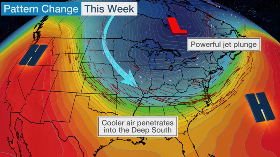
A much chillier weather pattern has settled into the Midwest, East and South this week and there is the potential for frost and freeze, even a few snowflakes, as the calendar turns to October.

The autumnal equinox officially kicked off fall in the Northern Hemisphere last Tuesday, and as the calendar flips to October this week, it should also feel like fall in much of the eastern half of the nation.

This change is being driven by a shift in the jet stream, which is taking a sharp southward nosedive over the central and eastern U.S. in response to a pair of high pressure systems bulging north over western North America and the western Atlantic Ocean.

This jet stream plunge will tap chillier air from Canada and pull it through much of the central, southern and eastern U.S. At the same time, it will bring drier and hotter weather to the fire-fatigued West.

This pattern should hold into early next week.

High/Lowlights

A second, reinforcing push of chilly air is dropping into the Midwest and will plunge through the South Thursday and Friday. Behind this second front, daytime highs won't rise out of the 40s in the northern Great Lakes, 50s in much of the rest of the Midwest and 60s as far south as the Tennessee Valley and Carolinas late this week.

(MAPS: 10-Day U.S. Forecast Highs/Lows)

Morning lows late this week could plunge into the 30s in the northern and central Plains, parts of the Midwest, and even in a few of the coldest spots of the Appalachians. The coldest spots in the northern Great Lakes will likely plunge into the 20s. Some of these areas could see their first frost or freeze of the season.

Lows in the 40s are likely into the Southern Plains and Deep South.

(MORE: The Earliest You Could See a Freeze in Your Area)

One final chilly reinforcement may plunge through the Midwest this weekend, then into the South early next week.

Forecast Morning Lows

Lake-Effect Flakes?

There's one other interesting facet to this chillier pattern.

Water temperatures over the Great Lakes are usually still fairly near their annual peak as fall begins because of a summer's worth of heating.

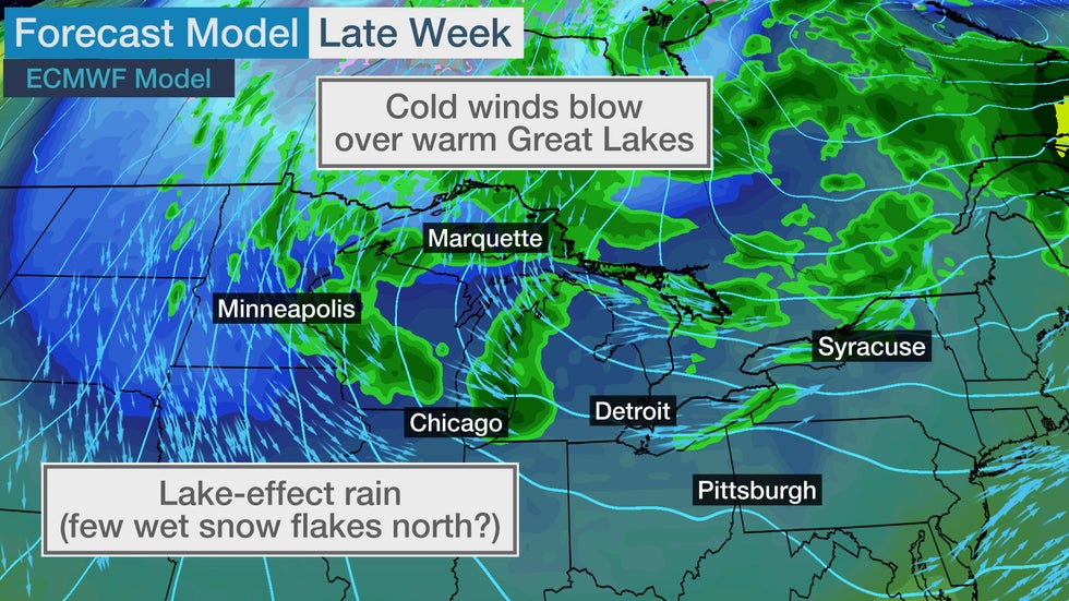
So colder air flowing over these relatively warm bodies of water will generate bands of lake-effect precipitation, primarily rain, at times this week.

The setup for lake-effect rainbands later this week in the Great Lakes. A few wet snowflakes could also fall in the northern Great Lakes.

The larger the difference between the cold air and warmer lake, the more vigorous the lake-effect precipitation.

Wednesday afternoon, a band of lake-effect thunderstorms rolled off Lake Erie into Buffalo and other parts of western New York.

There were even some waterspouts Wednesday morning in the eastern Great Lakes, and more are expected through Thursday or Friday, given the air-lake temperature difference and the strength of spin in the atmosphere, or what meteorologists refer to as vorticity.

(MORE: October Temperature Outlook)

The deep cold air well above the surface was unstable enough to trigger thunderstorms with small hail in the Twin Cities and parts of Michigan, as well, Wednesday.

Parts of the northern Great Lakes could even see a few first snowflakes of the season mix in, most likely Thursday night and Friday night.

If this happens, it would primarily be away from the warmer lakeshore over the interior of Michigan's Upper Peninsula, extreme northern Wisconsin or perhaps the Arrowhead of Minnesota.

Quite the way to usher in October, right?

The Weather Company’s primary journalistic mission is to report on breaking weather news, the environment and the importance of science to our lives. This story does not necessarily represent the position of our parent company, IBM.

The Weather Company’s primary journalistic mission is to report on breaking weather news, the environment and the importance of science to our lives. This story does not necessarily represent the position of our parent company, IBM.

A Tropical Depression or Storm May Develop in Western Caribbean Sea This Weekend

 Linda Lam and Chris Dolce

Published: September 30, 2020


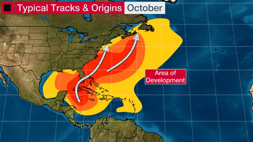
A tropical depression or storm may develop this weekend in the western Caribbean Sea, one of October's typical hot spots, but its future next week remains unclear.

A stalling-out frontal boundary arriving from the Gulf of Mexico, a tropical wave moving westward over the warmer-than-average Caribbean Sea could help develop a tropical depression or storm.

Some computer forecast models suggest something called a Central American Gyre, or CAG, could form. This "gyre" is a large, broad area of low pressure that often forms in late spring and early fall over Central America and the western Caribbean Sea.

What's important about the CAG is that it can instigate the development of tropical storms, often as spokes of energy rotating around it.

Such was the case with Tropical Storm Cristobal - and its eastern Pacific companion, Tropical Storm Amanda - in late May and early June.

Another example of a recent CAG-spawned storm was Hurricane Nate in early October 2017.

For now, the National Hurricane Center (NHC) says there is a better than 50/50 chance of tropical development in the western Caribbean Sea by this weekend.

A Hurricane Hunter mission may investigate the disturbance as soon as Friday afternoon, according to the NHC's "plan of the day" issued Wednesday.

Area to Watch

It's too soon to determine exactly where this disturbance will track and how strong it may get, since it is yet to form and may not form at all.

For now, the majority of computer forecast models that do develop a depression or storm track it slowly in the general direction of Mexico's Yucatan Peninsula - including Cancún and Cozumel - this weekend, then possibly into the Bay of Campeche by early next week.

Those in the western Caribbean or near the Gulf of Mexico need to be aware of the potential for a developing system. Check weather.com for updates as those details become more clear over the next several days.

The other important note about a CAG is it often is a prolific rain producer in Central America. So, this setup could lead to dangerous flash flooding in parts of eastern Mexico, Belize, Guatemala, El Salvador, Honduras and Nicaragua regardless of whether a tropical depression forms or not.

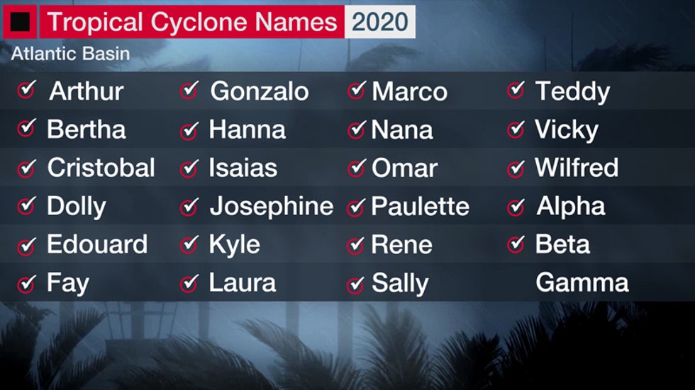
The next tropical storm to form in the Atlantic would be named Gamma.

(MORE: All the Records the 2020 Hurricane Season has Broken So Far)

Western Caribbean an October Hot Spot

Even though the climatological peak of the hurricane season – Sept. 10 – has passed, residents along the Gulf and East coasts need to remain prepared for a hurricane. Roughly one-fifth of all U.S. hurricane landfalls have occurred in October and November.

(MORE: What the Busiest Hurricane Seasons Have Delivered in October)

On average, one hurricane forms every year in October, according to the National Hurricane Center. The most hurricanes to form in October was five in 2010.

By October, the formation zones of tropical storms and hurricanes shift westward toward the western Caribbean Sea, eastern Gulf of Mexico and far western Atlantic Ocean as the "Cabo Verde" portion of the hurricane season, featuring the development of African easterly waves in the eastern Atlantic Ocean, fades.

In South Florida, October is the month with the most hurricane direct hits. Over two dozen October hurricanes have passed within 100 nautical miles of downtown Miami since 1851, according to NOAA's best track database.

Hurricane season quiets down as we head into November, especially for the United States.

There are just three known U.S. hurricane landfalls in the month of November dating to 1861.

Hurricane Kate in 1985 was the latest-in-season hurricane landfall in the U.S. Kate came ashore at Mexico Beach, Florida, on Nov. 21, a week before Thanksgiving.

The Weather Company’s primary journalistic mission is to report on breaking weather news, the environment and the importance of science to our lives. This story does not necessarily represent the position of our parent company, IBM.

The Weather Company’s primary journalistic mission is to report on breaking weather news, the environment and the importance of science to our lives. This story does not necessarily represent the position of our parent company, IBM.

Great Lakes Waterspouts Signal Lake-Effect Season is Ramping Up

 Tom Niziol

Published: September 30, 2020


You are probably familiar with those beautiful tropical waterspouts often photographed off the coast of Florida or in the Bahamas.

You might not know, however, that waterspouts are also common on the Great Lakes this time of the year.

In fact, this week, there's a multi-day waterspout outbreak on the Great Lakes.

And this isn't the first such outbreak of the season.

According to the International Centre for Waterspout Research (ICWR), 42 waterspouts or funnel clouds were confirmed on August 5, alone – 41 over Lake Erie, and another one over Lake Ontario. The daily record for waterspouts on the Great Lakes at 67 on Oct. 20, 2013.

The Glossary of Meteorology defines a waterspout as "an intense columnar vortex – usually containing a funnel cloud – that occurs over a body of water and is connected to a cumuliform cloud."

In layman’s terms, that means a column of spinning air occurring over a body of water, connected to puffy cumulus clouds.

There are two types of waterspouts:

1. Tornadic: Associated with a rotating, supercell thunderstorm that produces extreme winds and damage. These are quite rare on the Great Lakes.

2. Fair-weather: A common type that occurs in generally fair weather without a connection to a dangerous supercell thunderstorm.

Fair-weather waterspouts typically have weak circulations and winds. The bigger ones produce wind gusts that can exceed 50 mph and flip a small boat or damage a dock if they come onshore.

Fortunately, these types of waterspouts also move relatively slowly and are most often visible over the flat expanse of the lake waters from a great distance, so there is ample time to get out of their way.

It also allows for some spectacular photos and videos.

Great Lakes waterspouts are also known as cold-air funnels. As the name implies, they occur when cooler air moves across the warmer waters of the Great Lakes.

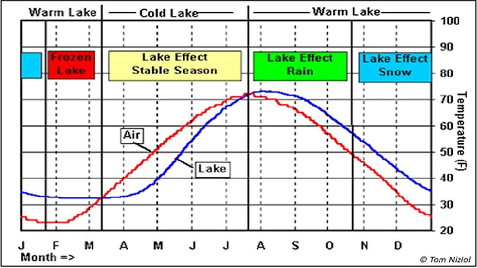
By late July and early August, the Great Lakes are at their warmest. Water temperatures can rise to 80 degrees in the rather shallow water of Lake Erie.

It’s also the time of the year when cooler air from Canada begins to make its first venture across the border and over the Great Lakes.

The average air temperature and Lake Erie water temperature at Buffalo, New York, defines the various lake-effect seasons. The waterspout season on the Great Lakes generally matches that time of the year when the water temperature is warmer than the air temperature. In the graph above, it roughly covers the months of August through October, which coincides with the period when lake-effect rain showers occur.

There is a waterspout season – a subset of the same lake-effect season that produces those epic snowstorms in the late fall and winter on the Great Lakes.

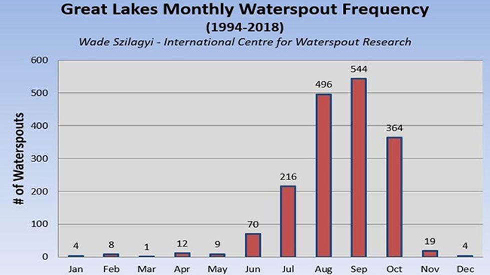
Waterspout season typically ramps up in the latter part of July and lasts into October. August and September are the most common months for Great Lakes waterspouts.

Monthly waterspout frequency on the Great Lakes from 1994 through 2010. The season typically begins in late July and extends through October.

So what does cold air moving across warm water have to do with waterspouts?

When that cool air moves across the warmer water, a steep drop in the air temperature develops from the warm lake surface upward a few thousand feet in altitude through the cooler air.

The drop in temperature with height is referred to as the "lapse rate." A steep lapse rate allows warm air near the lake surface to become very buoyant and rise rapidly like a hot air balloon into the colder air above.

Soon, rapidly developing cumulus clouds build, and below those clouds, the updrafts in that buoyant air strengthen.

If the winds near the surface are relatively weak, it allows for small, organized rotations to develop, which are lifted into a vertical column below those cumulus clouds. That rotating column of air gets stretched with the updraft, resulting in the spin-up of a waterspout.

The favorable conditions for waterspout formation (i.e. cold air outbreaks across warm waters of the Great Lakes) can be forecast to some degree.

The most common weather pattern to bring those colder temperatures aloft is a closed upper-level low that moves across the Great Lakes.

The ICWR issues daily forecasts for the potential for waterspout activity across the Great Lakes.

If you live near the Great Lakes, watch for those upper-level lows, head out to the lakeshore and if you’re lucky, you might just see one of these wonders of nature develop right before your eyes.

And, as alluded to earlier, it also marks a change of seasons when we begin to see lake-effect precipitation increasingly possible, as the air temperature trends cooler than Great Lakes water temperatures.

It’s time to get ready for the lake-effect season as it brings all sorts of interesting weather from now through winter.

The Weather Company’s primary journalistic mission is to report on breaking weather news, the environment and the importance of science to our lives. This story does not necessarily represent the position of our parent company, IBM.

The Weather Company’s primary journalistic mission is to report on breaking weather news, the environment and the importance of science to our lives. This story does not necessarily represent the position of our parent company, IBM.

Man missing at sea for nearly 2 weeks found alive in life raft off Washington coast

  One of two men missing at sea for nearly two weeks was found alive on Thursday by a Canadian fishing boat in a life raft in Canadian water...