Jonathan Erdman
Hurricane Laura will produce a dangerous, life-threatening storm surge along parts of the Louisiana and Texas coasts when it makes landfall. As recent past Gulf of Mexico storms have shown, storm surge is as much about a hurricane's size as its intensity, among other factors.
Hurricane Laura's storm surge could flood normally dry areas with over 10 feet of water along parts of the upper Texas and Louisiana coast, according to the National Hurricane Center.
 Hurricane Laura Storm Surge Forecast
First, let's explain the concept of storm surge.
Storm Surge Basics
A storm surge is a temporary rise of water above normal tide levels generated by a storm or hurricane.
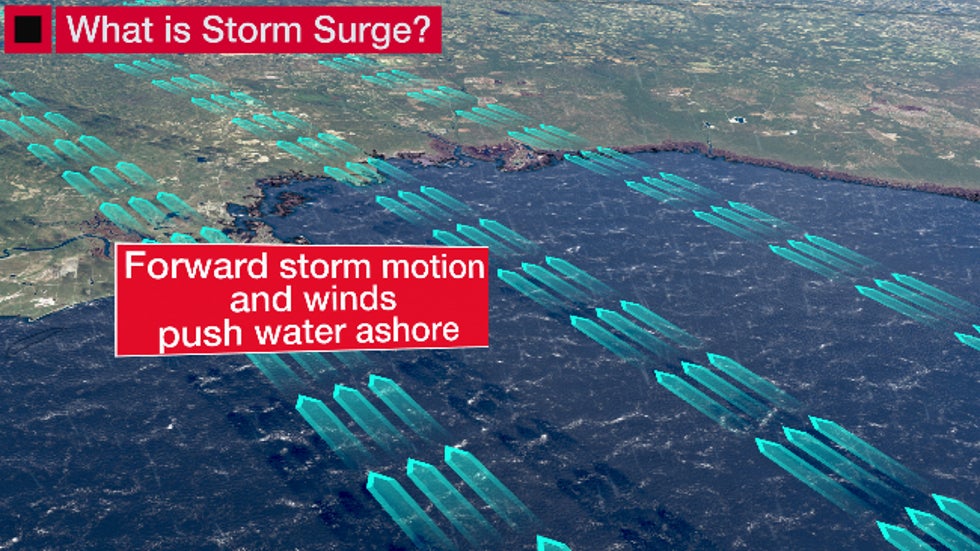
This happens because winds flowing around a storm push ocean water toward the coast, which eventually piles up and floods normally dry land near the shoreline.

This storm surge reaches a climax as the hurricane makes landfall typically along and to the right of the path of the hurricane's center, in the Northern Hemisphere.
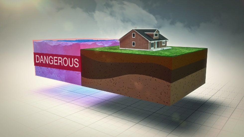
This inundation of dry land can be on the order of a few feet or can be 10 feet or more. Battering waves riding atop the storm surge can destroy well-built homes. In some cases, it can sweep buildings away, leaving only an empty slab of the foundation behind.
 The inundation above normally dry ground from storm surge.
According to a 2014 study from the NHC, almost half of all U.S. deaths from tropical cyclones were from storm surge.
In some cases, the destruction from storm surge can extend miles inland along bays, lakes and estuaries. It can even wipe out parts of coastlines, cutting new inlets in barrier islands and peninsulas.
The NHC issues storm surge watches and warnings when the threat of storm surge is either possible or expected. The NHC also publishes potential storm surge flooding maps indicating areas where flooding could occur in a given hurricane or tropical storm.
Size Matters, Too
A hurricane's intensity is far from the only factor determining the magnitude of its storm surge.
When you hear "Category 3," that refers to the hurricane's winds on the Saffir-Simpson Hurricane Wind Scale.
For instance, a slower-moving hurricane generates a longer-lasting storm surge than a fast-mover and can drive the surge deeper into bays and inlets.
A hurricane that directly approaches the coast at a right angle will produce a higher surge than one that moves parallel along a coastline.
A gentler slope of the ocean's shelf toward the shore will also lead to higher storm surge than those cases where the slope has a steep dropoff. Much of the U.S. Gulf Coast has this shallow shelf, making it prone to storm surge.
Finally, there's a hurricane's size, or, more precisely, how large its wind field is. In general, the larger the wind field, the more of the ocean a storm's strong winds cover and, therefore, the higher the surge generated.
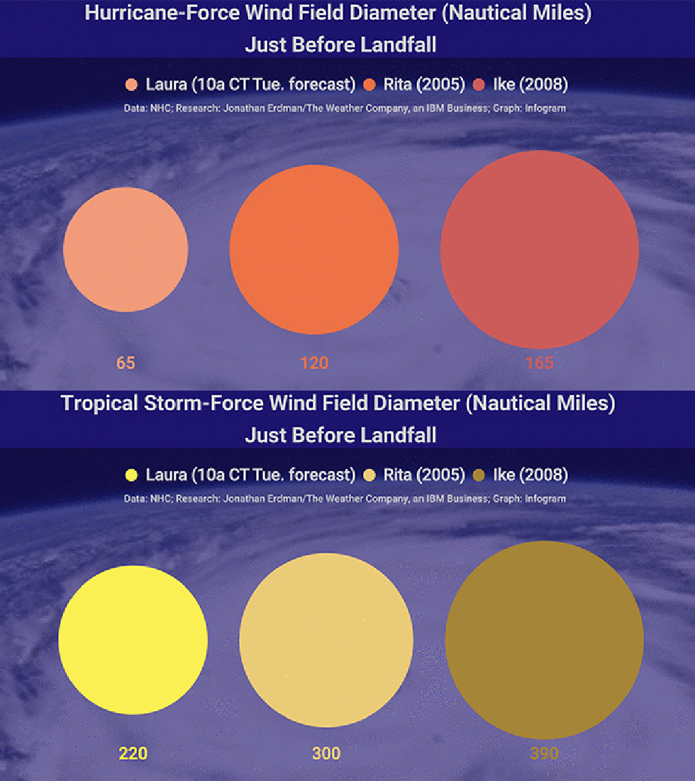
Below is a comparison of the tropical-storm-force (at least 39 mph winds) and hurricane-force wind field (at least 74 mph winds) forecast for Hurricane Laura just before landfall from the 10 a.m. CDT Tuesday NHC forecast, compared to the wind fields just before landfall in 2005's Hurricane Rita and 2008's Hurricane Ike.
 Tropical storm and hurricane-force wind field (peak wind diameter, in nautical miles) forecast for Hurricane Laura (from the 10 a.m. CDT, Tuesday NHC forecast) compared to the wind fields prior to landfall of both Hurricane Rita (2005) and Hurricane Ike (2008).
Ike was a Category 2 hurricane at landfall along the southeastern Texas coast in September 2008. By that wind scale, it was not a "major" hurricane (Category 3 or stronger). But you won't find many folks impacted by Ike's storm surge who wouldn't call it a major event.
Despite Ike's somewhat lower wind intensity, its giant wind field generated a 15- to 20-foot storm surge that wiped out most structures on the Bolivar Peninsula of Texas, southeast of Houston.
 An aerial photo shows damage by Hurricane Ike on Sept. 13, 2008, on the Bolivar Peninsula in Galveston County, Texas.
Hurricane Rita in 2005 topped out at Category 5 intensity over the southern Gulf of Mexico as one of the most intense Atlantic hurricanes on record.
While it "weakened" to a Category 3 at its landfall near the Texas-Louisiana border, its large wind field drove an up-to-15-foot storm surge into southwestern Louisiana, leveling Holly Beach, Cameron, Creole and Grand Cheniere.
Surge flooding from Rita extended as far north as Interstate 10 – about 25 miles inland – swamping Lake Charles, Louisiana, in up to 6 feet of water. An 8- to 12-foot storm surge was estimated in parts of Vermillion, Iberia and St. Mary parishes, while a 3- to 5-foot surge inundated Port Arthur, Texas.
The National Hurricane Center said late Tuesday afternoon storm surge from Hurricane Laura could penetrate up to 30 miles inland over southwest Louisiana and extreme southeast Texas.
 Cars traveling on flooded Route 82 in Cameron Parish, Louisiana, Oct. 1, 2005, pass structures destructed by Hurricane Rita.
Take storm surge as a serious danger, regardless of how strong a hurricane's wind intensity is.
Before a hurricane threatens, find out if you live in an evacuation zone. Knowing this – and heeding evacuation orders from local emergency managers – could save your life and those of your family members.
The Weather Company’s primary journalistic mission is to report on breaking weather news, the environment and the importance of science to our lives. This story does not necessarily represent the position of our parent company, IBM.
The Weather Company’s primary journalistic mission is to report on breaking weather news, the environment and the importance of science to our lives. This story does not necessarily represent the position of our parent company, IBM.

No comments:
Post a Comment