August weather typically showcases several weather changes, including an increase in hurricane activity and decreases in daylight and temperatures.
Here's what to expect:
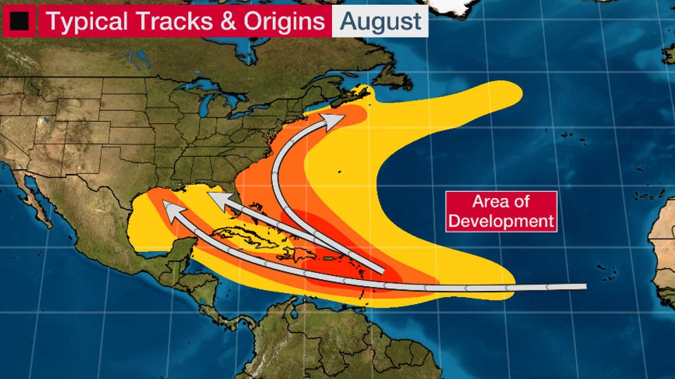
Atlantic Hurricane Season Ramps Up
The Atlantic hurricane season officially runs from June through November. In most years, the first two months of the season are usually benign.
Then comes August, and it's almost as if a switch is flipped.
The second named storm typically forms around Aug. 1. But this year is on a record storm pace.
(MORE: Why August Marks the Beginning of the Busiest Time of Hurricane Season)
August sees more than three times the number of named storms as July, on average, and almost double the number of June and July storms combined.
Several factors contribute to the seasonal ramp-up:
-African easterly waves or tropical waves are most developed and often serve as a seed for tropical development.
-Saharan air layers (surges of dry air into the central and eastern Atlantic Basin, which normally squelch tropical development in those areas) tend to give way by August, as the parade of African easterly waves gradually adds moisture. This effectively opens up more favorable real estate for tropical cyclone development.
-Wind shear (the change in wind speed and/or direction with height that can rip apart a tropical cyclone wannabe) tends to be lower.
-Sea-surface temperatures rise toward a peak in early fall.
-Instability, or the atmosphere's ability to generate convection (thunderstorms) to help initiate tropical cyclones, also rises toward an early-fall peak.
Keep in mind that averages and climatology are no guarantee of an outcome in any individual hurricane season.
 Typical origins and tracks of tropical cyclones in August in the Atlantic Basin. The orange and red contours show where named storms are more likely.
Tornado Risk Greatest in Parts of the Northern Tier
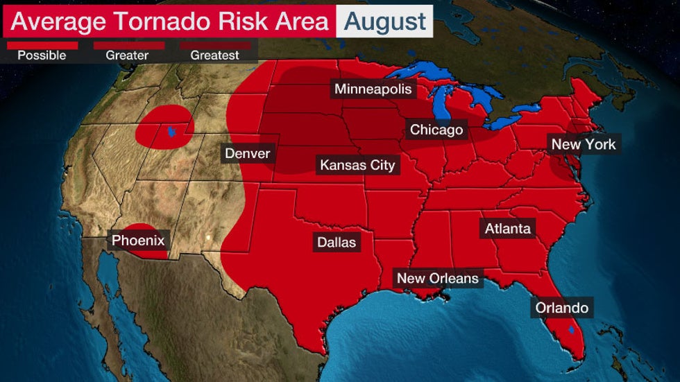
Tornadoes are a risk in August, particularly in the northern tier of the country, even though the average number of twisters decreases from July.
The greater risk extends from the Northern Plains to the Midwest and in parts of the Northeast and mid-Atlantic because the jet stream is located farther north toward the Canadian border.
Tropical cyclones can also produce tornadoes.
 Average tornado risk in August, based on data from 1991-2015.
August Is the Wettest Month in Parts of the South and Alaska
The Southwest monsoon usually ramps up in August and sometimes results in severe thunderstorms.
August is the wettest month on average for most of Arizona, New Mexico and southern Colorado because of monsoonal moisture.
Portions of the Southeast coast also experience their wettest month in August. Afternoon and evening thunderstorms are common there and rainfall from tropical cyclones sometimes occurs. August is also the wettest month in much of Alaska.
Average Temperatures and Daylight Begin Their Decline
Much of the country experiences the warmest time of the year in July. However, August is typically the warmest month for much of the Southern Plains, lower Mississippi Valley, parts of the northern tier from North Dakota to Washington state, as well as southward along the immediate Pacific coast through California.
 Various shadings indicated the warmest day of the year based on 1981-2010 climatological averages.
The rest of the U.S. begins to cool off. This translates to afternoon temperatures in the 80s and 90s for most.
The Desert Southwest remains the hot spot, with average highs above the century mark.
Meanwhile, areas from the upper Mississippi Valley into northern New England often cool into the 70s as more potent cold fronts begin to pass through the northern U.S. again.
 Average Highs in August
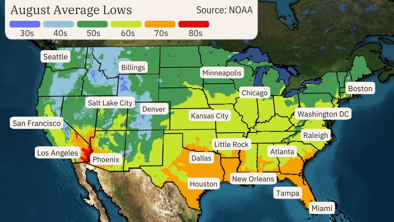
Overnight temperatures also begin to drop. Slightly lower humidity allows for cooler lows, in the 50s and 60s, for much of the East, while the Gulf Coast remains in the 70s with humidity still hanging on.
Low temperatures remain in the 70s and even the 80s in the Desert Southwest as monsoonal moisture continues flowing into the region.
The coolest air is typically found in parts of the higher elevations West, where lows being to drop into the 40s.
 Average Lows in August
The length of daylight also quickly declines through August as the autumnal equinox, 12 hours of day and night, approaches in September. Most cities in the northern half of the nation lose two to three minutes of daylight each day in August.
The sunset in New York City is at 8:10 p.m. on Aug. 1, but by Aug. 31, the sun dips below the horizon at 7:28 p.m. In Seattle, the sun sets at 8:42 p.m. on Aug. 1 but sets 52 minutes earlier at 7:50 p.m. on Aug. 31.
Snow Can Start to Fall in the Rockies
Snow becomes a fairly typical occurrence in late August in the highest peaks of the Rockies, especially the Canadian Rockies.
(MORE: It May Seem Too Soon, But August Snow Can Happen)
Last year, the first winter storm warning of the season was issued by the National Weather Service on Aug. 20 for parts of Alaska. A dusting of snow was captured by webcams in the Brooks Range.
America's northernmost town, Utqiaġvik, Alaska – formerly known as Barrow – typically sees its first measurable snow, at least 0.1 inches, on Aug. 23, based on the latest 30-year average from 1981 to 2010. Fairbanks typically experiences its first measurable snow in late September, but has recorded snow as early as Aug. 25 in 1995.
Early-August snow is more unusual but did occur on top of Pikes Peak and Mount Massive in the Colorado Rockies in 2017. Snow as also spotted last year around Aug. 20 in Colorado.
Snow isn't just confined to the highest elevations in August. Great Falls, Montana, saw its earliest snow on Aug. 22, 1992, the same year its only below-freezing temperatures were recorded in August.
In the East, Mount Washington, New Hampshire, has recorded snow in August, with an average of 0.1 inches falling during the month. The most snow measured there in August was 2.5 inches in 1965.
The Weather Company’s primary journalistic mission is to report on breaking weather news, the environment and the importance of science to our lives. This story does not necessarily represent the position of our parent company, IBM.
The Weather Company’s primary journalistic mission is to report on breaking weather news, the environment and the importance of science to our lives. This story does not necessarily represent the position of our parent company, IBM.

No comments:
Post a Comment