A weather pattern called an omega block will develop across the United States by early next week, and it will bring cooler conditions to the West, heat up the Midwest and trigger the development of storms in parts of the East.
Here's how it works: There will be two southward plunges of the jet stream forming this weekend, one in the West and another over the East Coast. In between will be a ridge of high pressure, or a northward bulge in the jet stream, from the Midwest into Canada.
Now, notice how the jet stream pattern – that ribbon of fast-flowing air some 30,000 feet above the ground - described above and depicted in the image below resembles the greek letter omega: Ω.
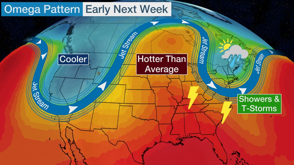
The term omega block is not new — it's often taught in basic meteorology courses. The jet stream's exaggerated north-to-south alignment will cause the weather pattern to move slowly for a time, which is where the term block comes into play. Essentially, the weather pattern is clogged up, and this prevents weather systems from progressing at a steady pace from west to east like they normally do.
This weather pattern will be in place early next week. Here's a closer look at what this means for the forecast.
Temperature Dichotomy
Temperatures will tumble from above average to below average across many parts of the West beginning this weekend.
Boise, Idaho, will be in the 90s late this week, but by Sunday and Monday, it will not get out of the 60s.
Highs in Salt Lake City could tumble about 25 degrees Sunday into Monday, from the lower 90s into the 60s.
Parts of western Montana, including Butte, might not get out of the 50s early next week.

This new weather pattern will also spread rain showers from the Pacific Northwest into Montana this weekend into early next week. Some of the highest peaks in the northern Rockies above 8,000 feet in elevation could even see summertime snowfall Sunday into Monday.
Meanwhile, the Midwest will heat up next week under the building ridge of high pressure.
By Monday, an area from the western Plains and Dakotas to the Great Lakes will have high temperatures 5 to 20 degrees above average.
Fargo, North Dakota, could see multiple days in the lower to mid-90s. Chicago and Minneapolis are forecast to see highs in the upper 80s and lower 90s early next week.
Showers and Storms in the East
The southward plunge of the jet stream in the East in this weather pattern will likely produce some areas of showers and storms.
New England is one location that could see rainfall through early next week. This is good news for that region since drought conditions have recently developed in some areas.

Another area that could see stormy weather early next week extends from the Southeast into the Ohio Valley. That's where disturbances will ripple through the southern periphery of the jet stream dip.
Other parts of the Northeast and mid-Atlantic could eventually see showers and storms as the week progresses, but that will depend on exactly how this weather pattern evolves.
The Weather Company’s primary journalistic mission is to report on breaking weather news, the environment and the importance of science to our lives. This story does not necessarily represent the position of our parent company, IBM.
The Weather Company’s primary journalistic mission is to report on breaking weather news, the environment and the importance of science to our lives. This story does not necessarily represent the position of our parent company, IBM.


No comments:
Post a Comment