Published: April 11, 2020

A dangerous severe weather outbreak is likely across a large part of the South over Easter weekend, including threats of tornadoes, widespread damaging winds, very large hail and flooding rain.
April is a notoriously volatile month for severe thunderstorms and tornadoes in the United States, and the overall setup this weekend has grabbed the attention of meteorologists.
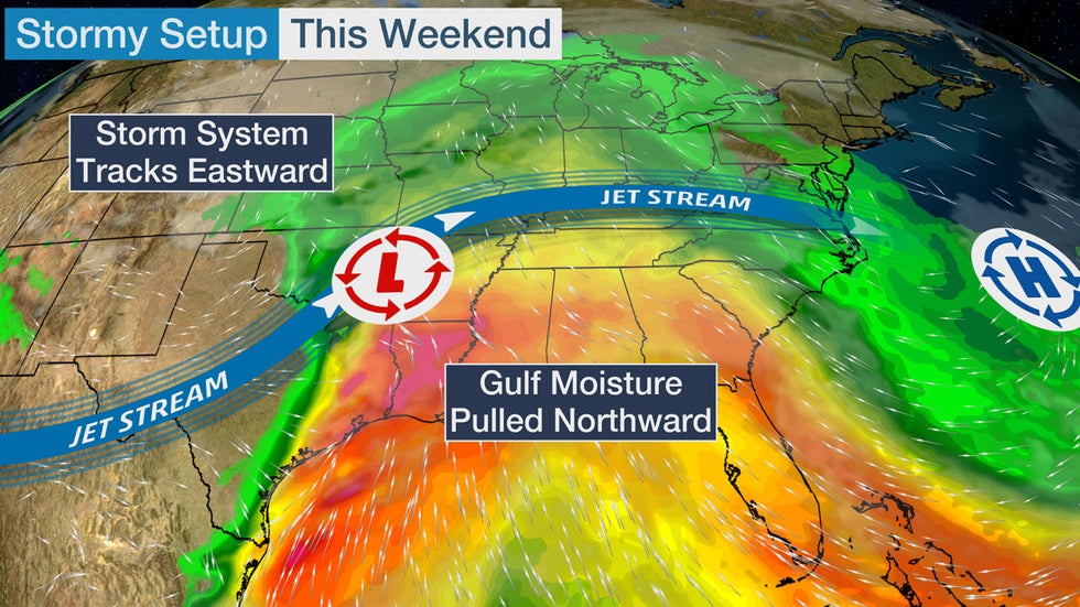
A slow-moving upper-level low-pressure system that brought rain to California and the Desert Southwest much of the week will finally accelerate eastward this weekend. This area of low pressure will rapidly strengthen as it tracks from the Plains into the Great Lakes.
Increasingly warm and humid air is expected to stream northward off a much-warmer-than-average Gulf of Mexico ahead of the upper-level low, providing fuel for thunderstorms. In fact, a strong atmospheric river from the Gulf of Mexico will be in place by Sunday night.
Increasing wind shear – the difference in wind speed and/or direction with height – will support severe thunderstorms.
This overall setup is fairly clear. But there remains some uncertainties in the details of this severe forecast.
(IN DEPTH: Bob Henson Breaks Down the Severe Threat)
First, these upper lows moving out of the Southwest are among the biggest stumbling blocks for computer models and weather forecasters. They often move slower than expected and make forecasts a challenge.
Secondly, a large area of heavy rain may develop over the South that would suppress the instability needed for severe thunderstorms in some areas for at least some period of time.
Despite these uncertainties, the setup is volatile enough that an outbreak is increasingly possible, including tornadoes that could be strong and have long tracks, along with widespread damaging thunderstorm winds and hail.
Keep in mind that storm shelters may not be an option in some cases due to COVID-19. More on that at the bottom of this article and here: Coronavirus and Shelters, What Do I Do?
Here is our latest thinking on the severe weather potential each day this weekend. This forecast will be updated as the details come into focus in the days ahead, so check back to weather.com.
Saturday
Severe thunderstorm coverage during the day Saturday in parts of Texas may be scattered. Large hail will be the primary threat with any storms that develop during the day.
Severe thunderstorms should become more numerous late Saturday night in Texas and possibly parts of Louisiana. A few strong to severe thunderstorms may also extend northward into parts of Oklahoma, Kansas and Arkansas.
Very large hail, damaging wind gusts and a couple of tornadoes are all concerns.
Thunderstorms with heavy rain may also spread into other parts of the Deep South, including Mississippi and Alabama, and perhaps Georgia Saturday night.
 Saturday-Saturday Night Severe Thunderstorm Forecast
Easter Sunday
A severe weather outbreak is increasingly likely, with widespread severe thunderstorms sweeping across the Deep South from the lower Mississippi Valley earlier in the day to parts of Alabama, Tennessee, Georgia, North Florida and the Carolinas Sunday night.
Thunderstorms are expected to be ongoing Sunday morning in eastern Texas and will move eastward into the lower Mississippi Valley by late Sunday morning. Long-track supercell thunderstorms may develop in parts of Mississippi and Alabama by Sunday afternoon.
Here's a look at the timing state by state. Locations within each state won't experience severe weather for the entire time windows, but this is general guidance on when each state as a whole may experience severe weather:
- Texas: Saturday - mid-morning Sunday
- Louisiana: Mid-morning Sunday - late afternoon Sunday
- Mississippi: Late morning Sunday - mid-evening Sunday
- Tennessee: Sunday evening - Monday morning
- Alabama: Mid-afternoon Sunday - very early Monday
- Georgia: Late evening Sunday - late morning Monday.
Tornadoes, widespread damaging thunderstorm winds and large hail are all threats. Some tornadoes may be strong with long tracks. In the eastern portions of the threat areas shown on the map below, the severe weather may occur at night.
There is the potential for at least some severe thunderstorms to spread farther north into the Ohio Valley.
 Sunday-Sunday Night Severe Thunderstorm Forecast
Monday
The chance for severe thunderstorms may extend into early Monday afternoon from northeastern Florida into parts of the mid-Atlantic, possibly as far north as southern New Jersey.
Damaging wind gusts and a few tornadoes are the primary concerns on Monday.
 Monday Severe Thunderstorm Forecast
Flash Flood Threat
In addition to the threat of severe thunderstorms and tornadoes, bands of heavy rain are expected across much of the South through Monday morning.
These heavy rainbands may trigger flash flooding, particularly if they stall out for a period of an hour or more. The heavy rain may occur hours ahead of the peak severe weather threat time.
Excessive rainfall may prompt flash flooding on Saturday in parts of northeastern Texas, northwestern Louisiana and southern Arkansas.
 Locally heavier rain amounts may occur where bands of rain stall for a period of an hour or more.
The chance for flash flooding increases on Sunday. NOAA's Weather Prediction Center has issued a moderate risk of excessive rainfall from southwestern Arkansas and northern Mississippi into northern Alabama, northern Georgia, Tennessee and parts of the western Carolinas.
As always, heed all flash flood warnings, and if you have to leave home and drive, never cross a flooded road.
 Excessive Rainfall Outlook
Severe Weather and Coronavirus: Do I Shelter?
The simple answer: yes.
However, sheltering may be more difficult over the next few months.
"Do not let the virus prevent you from seeking refuge from a tornado," the American Meteorological Society said in a statement issued Thursday. "If a public tornado shelter is your best available refuge from severe weather, take steps to ensure you follow CDC guidelines for physical distancing and disease prevention."
But you need to know where to go and IF you can go to a shelter BEFORE a storm threatens.
“Most government entities use schools … you can only get so many people in those schools," Steven Still, director of emergency management in New Hanover County, North Carolina, told weather.com.
Of course, many schools are closed during this pandemic, so your normal shelter may not be open. And those shelters that are open may not accept as many people.
In all cases, if you are in a mobile home, absolutely find a different shelter option.
While the Red Cross recently issued new guidelines for maintaining social distance in its shelters, local officials say it's not that easy.
The shelter question extends well beyond tornadic threats. As reported by weather.com’s Jan Wesner Childs, a team at the Union of Concerned Scientists has compared coronavirus projection models from Columbia University with NOAA's most recent spring flood forecast and came to some startling conclusions about which communities are most likely to be hit with both the global pandemic and spring flooding between now and May 31.
A few states have issued their own advice in recent weeks:
Alabama
The Alabama Department of Public Health and the National Weather Service in Birmingham issued a joint statement advising people to go to shelters, as did similar agencies in Mississippi.
"If a warning is issued for your area, you are more likely to be affected by the tornado than the virus," the statement from the Alabama officials said.
But they also noted it's up to county and city governments to decide how and when to open shelters.
"If you rely on public community shelters, now may be the time to explore other options that might keep you safer from severe weather and possibly limit your exposure to COVID-19," the statement said.
As we all do our part to lessen the impacts of COVID-19 on society at home & abroad, your NWS will continue to provide forecasts, warnings, & decision support to the public & our core partners to protect lives & property. Joint remark from AL NWS offices & ADPH on storm shelters:
33 people are talking about this
Mississippi
An agreed upon statement between NWS Jackson, the MS Emergency Management Agency and the MS Dept. of Health regarding sheltering due to hazardous weather during these unprecedented times, is shared for your viewership. We hope you find usefulness in this unified statement.
43 people are talking about this
The Weather Company’s primary journalistic mission is to report on breaking weather news, the environment and the importance of science to our lives. This story does not necessarily represent the position of our parent company, IBM.
The Weather Company’s primary journalistic mission is to report on breaking weather news, the environment and the importance of science to our lives. This story does not necessarily represent the position of our parent company, IBM.


No comments:
Post a Comment