Jonathan Belles
Published: April 5,2020
A slow-moving, but potent storm system will bring feet of Sierra Nevada snow and drenching rain to much of California through the first half of this week.
Colder-than-typical air is expected to accompany this system, which should allow for low snow levels and perhaps a few strong thunderstorms.
This system is already bringing rain to Northern and Central California and snow to the Sierra Nevada and Siskiyou Mountains.
 Current Radar, Satellite and Surface Pressure
The heaviest snow in the Sierra Nevada from this system is expected from now into Monday, when snow levels could drop to as low as 3,000 to 4,000 feet. Travel is highly discouraged, and winter storm warnings have been issued by the National Weather Service.
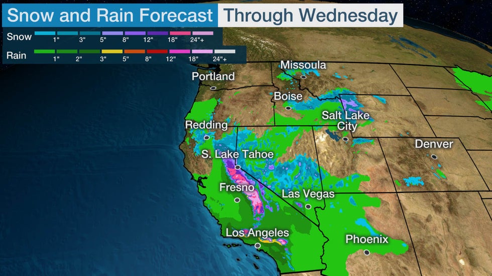
As much as 4 feet of snow is expected in the higher elevations of the Sierra, with 1 to 2 feet of snow in the Siskiyous and the Southern California mountains.
The Winter Storm Warning remains in effect for the Sierra and Southern Cascades through Monday Morning.
Travel is HIGHLY DISCOURAGED! Major travel delays, chain controls, road closures, & periods of whiteout conditions are expected! #cawx
See NWS Sacramento's other Tweets
Bands of moderate to heavy rain will sweep southeastward through the state into early Monday morning. Some hail and even an isolated tornado are possible in Central California.
Southern California could have heavier rain into Monday. Localized flash flooding and debris flows could occur, particularly in recent burn areas.
Showery weather should linger in Southern California through midweek, and snow levels may fall slightly as snowfall intensity drops some.
By late Wednesday, light rain and snow showers should spread eastward into the Four Corners region.
Generally, 1 to 2 inches of rain is likely across much of California, with higher totals possible in foothills.
 Snow and Rain Forecast
Overall, this system is good news for California's water resources.
California's snowpack is only roughly half of normal for early April. If this snowpack is not replenished before the wet season ends, reservoirs will lower and less water will be available for California's cities later in the year.
California is in a moderate drought after a drier-than-average fall and winter.
March 2020 and Water Year to date Precipitation update for San Luis Obispo, Santa Barbara, Ventura, and Los Angeles Counties in SW California. #LAweather #CAwx #CAwater #CAdrought #LArain #SoCal
17 people are talking about this
The recent wet pattern is good news for fire-weather concerns going into the dry season in California, so more precipitation is a welcome sight.
The Weather Company’s primary journalistic mission is to report on breaking weather news, the environment and the importance of science to our lives. This story does not necessarily represent the position of our parent company, IBM.
The Weather Company’s primary journalistic mission is to report on breaking weather news, the environment and the importance of science to our lives. This story does not necessarily represent the position of our parent company, IBM.


No comments:
Post a Comment