Published: April 9, 2020
 Preliminary storm reports from a severe weather outbreak on Jan. 10-11, 2020. (Note: Some initial reports of wind damage in the map above were later found to be from tornadoes after National Weather Service damage surveys.)
Severe weather outbreaks with hundreds of reports of wind damage, tornadoes and hail over multiple states are typically triggered by an extreme combination of atmospheric ingredients that set them apart from ordinary stormy days.
While there have been various proposals to define an outbreak, it's typically easy to spot an outbreak by looking at the density and number of reports of tornadoes, wind damage and hail after it happened. As the above example from January 2020 shows, if the map resembles a rash of reports, it's an outbreak.
In general, when at least several ingredients for thunderstorms are extreme in magnitude, numerous severe thunderstorms flare up.
Moisture
The fuel for thunderstorms is a supply of warm, moist air in the lowest levels of the atmosphere.
This should make sense, as most days with thunderstorms are at least somewhat warm and humid.
In general, the warmer and more humid the air is, the higher the potential for thunderstorms.
 Current U.S. Dew points
Instability
However, not every warm and humid day triggers thunderstorms in most parts of the world.
What's also important is how much colder and drier the air is above that warm, humid near-surface layer.
Meteorologists refer to this difference in temperature and moisture with height as instability.
The greater this difference, the more vigorous the thunderstorms, with air currents soaring tens of thousands of feet into the air.
There's a simple analogy you probably see almost every day in your kitchen.
When you first place water on the stove and turn on the burner, nothing immediately happens. The water (and pot) are both slowly warming, relative to the air above it. The instability is rising.
Once the water begins boiling, you notice steam rising. That's the process of convection – rising warm, moist air – that eventually condenses into clouds and forms thunderstorms.

Sources of Lift: Jet Streams, Fronts
Now, we need triggers, those atmospheric features that force a large number of thunderstorms to occur.
First, we need a sharp southward plunge of the jet stream, pivoting eastward out of the western United States.
This U-shaped jet stream plunge – known to meteorologists as a trough – forces a low-pressure system with cold and warm fronts to intensify to the east of it, drawing northward that increasingly warm and humid air we discussed earlier.
The instability comes into play because the air in the U-shaped jet stream trough is very cold, and winds aloft also transport dry air from the western U.S. or northern Mexico.
The strengthening frontal boundaries, and any zones of converging winds ahead of the cold front, such as a dryline, force this potentially unstable air to rise, resulting in an explosion of severe thunderstorms.
 A typical scenario for severe weather outbreaks, including a vigorous jet stream trough, its attendant low-pressure system and fronts.
Wind Shear
Thunderstorms have rising and sinking currents of air called updrafts and downdrafts. Downdrafts usually are laden with the thunderstorm's rain.
An ordinary midsummer thunderstorm along the U.S. Gulf Coast, for example, will develop but then rain itself out as its downdraft chokes off its updraft.
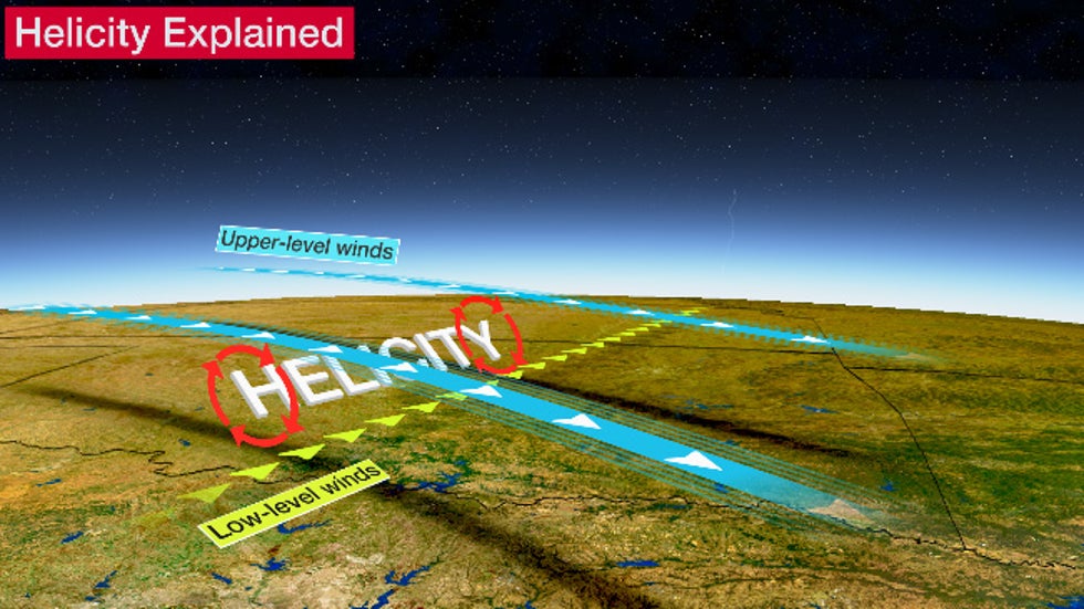
However, in a severe weather outbreak, the difference in wind speed and/or direction from closer to the ground to jet-stream-level can be massive.
This wind shear allows a thunderstorm to tilt so that its downdraft doesn't choke off its updraft, allowing it to last longer than the ordinary thunderstorm described above.
 Schematic of a supercell, showing the (forward flank) downdraft displaced downstream, allowing the rotating updraft to persist.
Wind shear produces a rotating supercell's updraft, which also helps maintain the supercell's longevity.
It does this by first producing a broad area of slowly rotating winds about a horizontal axis. You can demonstrate this by placing a pen in the palm of your hand, then placing your other hand over the pen and sliding one or both hands in opposite directions. The pen rotates.
A developing thunderstorm's updraft in this environment then tilts that horizontal tube of rotating air into the vertical and stretches it, causing the rotation to increase.

If this change in winds and instability is extreme in the lowest few thousand feet above the ground, as might occur near the warm front or low-pressure center in the map above, tornadoes – some strong – could develop within supercells.
While most strong tornadoes are spawned from supercell thunderstorms, some severe weather outbreaks aren't really about supercells.
For example, if a vigorous jet stream and cold front sweep quickly into warm and humid air without enough low-level shear for tornadic supercells, a long-lived squall line of severe thunderstorms may produce widespread straight-line thunderstorm wind damage over hundreds of miles and multiple states. This large-scale convective windstorm is known as a derecho.
The Weather Company’s primary journalistic mission is to report on breaking weather news, the environment and the importance of science to our lives. This story does not necessarily represent the position of our parent company, IBM.
The Weather Company’s primary journalistic mission is to report on breaking weather news, the environment and the importance of science to our lives. This story does not necessarily represent the position of our parent company, IBM.

No comments:
Post a Comment