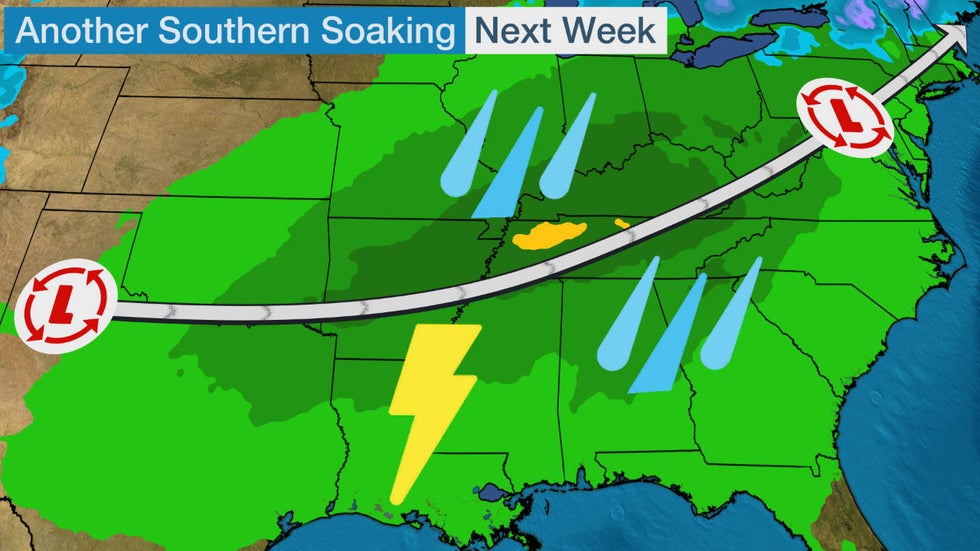
A new storm system could bring flooding rain and severe thunderstorms to parts of the South and Ohio Valley early next week.
This system will move into the Southern Plains and lower Mississippi Valley on Sunday, then sweep north and eastward across the South and Ohio Valley through the middle of next week. Moisture will begin to return to parts of the South on Sunday.
A few storms are possible from Arkansas and Missouri during the day Sunday before becoming more widespread Sunday night in the mid-South.
On Monday, rain will increase from eastern Texas and eastern Oklahoma into the lower and mid-Mississippi Valley, mid-South, Ohio Valley and parts of Pennsylvania and western New York. Thunderstorms are possible from eastern Texas to the lower Ohio Valley, but the chance for severe storms is low on Monday.
 Monday's Forecast
By Tuesday, the threat for rain will stretch from the Southern Plains to the Ohio Valley and parts of the East. The rain may be locally heavy at times, increasing the threat for flash flooding, particularly in the South because of an excessively wet February in much of the region.
Severe thunderstorms are possible Tuesday from eastern Texas into the lower Mississippi Valley, with damaging winds, large hail and a few tornadoes all potential threats.
 Tuesday's Forecast
The area of rain will slide across the South on Wednesday and at least a few severe storms can't be ruled out in portions of the South and East on Wednesday as well. Drier conditions are expected across the region by late Thursday.
It's too early to pinpoint where the heaviest rain might fall, but the map below provides an early look of where heavy rain is possible early to mid-next week. The highest rainfall totals are currently predicted to be in parts of the mid-South, Tennessee Valley and lower Ohio Valley, but check back for updates over the next several days.
 Rain and Snow Outlook
A February and Winter for the Record Books?
Over 90 river gauges are reporting flooding in the South. In some cases, river levels could take months to come down, and flooding could be prolonged in a few spots.
Rainfall has been nothing short of staggering in parts of the South.
Through Feb. 26, Tuscaloosa, Alabama, had picked up 15.49 inches of rain in February, ranking as the city's wettest winter month (December, January and February) on record. The previous record was 14.79 inches from February 1961. This month's rain is also more than Tuscaloosa measures in an average February and March combined (10.07 inches).
According to the Southeast Regional Climate Center (SERCC), February ranked as the wettest on record through Feb. 27 in Greensboro, North Carolina (7.23 inches); second wettest in Elizabeth City, North Carolina (6.77 inches); and third wettest in Knoxville, Tennessee (11.41 inches).
This may sound like déjà vu.
Knoxville was among a number of Southeastern cities that smashed February records last year.
For the first half of February, the majority of the NWS’s Southern Region has observed buckets full of rain. Parts of Mississippi and Alabama have had 10-14”, with more unfortunately on the way.


67 people are talking about this
It hasn't just been February either.
Again, according to the SERCC, winter 2019-20 – from Dec. 1 through Feb. 26 – has been the wettest to date in Columbia, South Carolina (20.63 inches), and Starkville, Mississippi (31.78 inches).
The only wetter winter to date in Jackson, Mississippi (29.17 inches so far), was 1982-83 (32.42 inches), also the last time the Pearl River was as high in the city.
Highlands, North Carolina (37.84 inches), and Haleyville, Alabama (34.25 inches), have each picked up over 30 inches of precipitation since Dec. 1.
A number of locations from Mississippi to the Smoky Mountains and Southeast have picked up 10 inches more precipitation than average this winter.
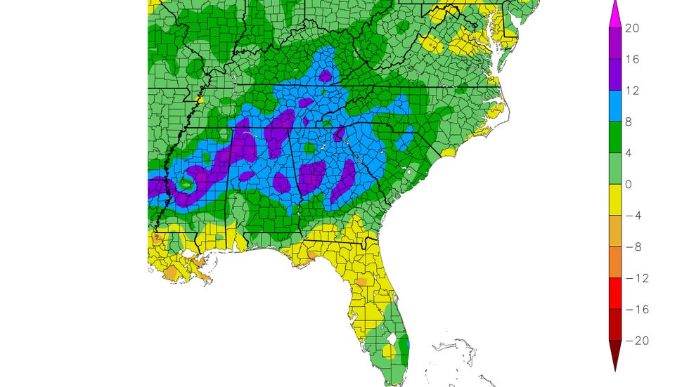 Departures from average precipitation over a 90-day period ending Feb. 25, 2020. Areas shown in the blue and purple contours have picked up at least 8 inches more precipitation than average during that time.
The Weather Company’s primary journalistic mission is to report on breaking weather news, the environment and the importance of science to our lives. This story does not necessarily represent the position of our parent company, IBM.
The Weather Company’s primary journalistic mission is to report on breaking weather news, the environment and the importance of science to our lives. This story does not necessarily represent the position of our parent company, IBM.


No comments:
Post a Comment