WINTER WEATHER Updated Feb. 27, 2020 10:03 AM
Snow has been limited across parts of central Europe this winter season, but a pair of quick-moving storms will work together to bring residents a taste of the season.
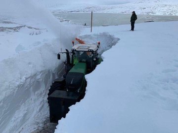
A storm charged through northwestern and central Europe Tuesday night and Wednesday and produced heavy snow in the Scottish Highlands as well as a quick round of snow in Sweden, which is recording its warmest winter since record-keeping began.
Chilly air that has been elusive this winter filtered into central and northwestern Europe in the wake of the storm.
A second storm raced through the southern United Kingdom and northern France Wednesday night.
The cold air lingering over these areas allowed rain to mix with and even change over to all snow for a period of time across parts of England, Wales, Northern Ireland and Scotland.
By Thursday morning, those across England awoke to a blanket of fresh snow on the ground.
The wintry conditions could cause slippery spots through much of the day Thursday before temperatures rise above freezing. Motorists should give themselves extra time to reach their destinations and leave enough distance between vehicles.
Through the end of the work-week, the storm impact the remainder of western and parts of central Europe where it will again run into the cold air left behind by the storm that moved through just days ago.
Precipitation across the region starts off as snow or a mix of rain and snow across much of the region, but as temperatures fall through Thursday night, any precipitation over the area will change over to all snow, especially across central and southern Germany.
The poor conditions on Thursday forced officials to cancel the women's World Cup Ski races in Germany that were scheduled to take place next week.
While the first storm kept snowfall mainly in higher elevations, the expansive cold air over the area will allow residents from extreme northern France, across Germany and into Poland to receive at least some snow.

However, accumulating snowfall will be largely limited to higher elevations.
The heaviest snowfall and greatest risk of travel delays will be across the Alps. Roads to ski resorts across the region may be closed, and the risk of avalanches could increase due to the fluctuating temperatures and heavy snowfall.
"Snowfall in the Alps will be 30-90 centimeters (1-3 feet) with an AccuWeather Local StormMax™ of 122 centimeters (4 feet) into the end of the week," Roys said.
These totals include the snowfall from Tuesday night into Wednesday, as well as additional snow from the late-week storm.
The snow will be a welcome sight for some. In France, which is having its mildest winter in 100 years, according to Reuters, one ski resort has had to close due to a lack of snow.
Le Mourtis, located in the Pyrenees, had to close its slopes to visitors in mid-February. Reuters reported that several other Pyrenees ski resorts in higher elevations have been able to say open.
RELATED:
Snow will continue to track farther east through Thursday night, spreading across Poland, the Czech Republic, Slovakia and eastern Hungary.
By Friday, temperatures will rise across these areas. Snow will change to rain except in the highest elevations.
Forecasters say another storm is set to move into central Europe this weekend and it could bring produce more wintry weather as precipitation arrives before temperatures increase.
Keep checking back on AccuWeather.com and stay tuned to the AccuWeather Network on DirecTV, Frontier and Verizon Fios.


No comments:
Post a Comment