Updated Jan. 10, 2020 10:03 PM
A severe weather outbreak is ripping across the southern United States with nearly 40 million Americans at risk for damaging thunderstorms and tornadoes.
Preparations began on Thursday night as Texas Gov. Greg Abbott announced in a press release that numerous state resources were being placed on standby in advance of the severe weather.
"As severe weather approaches the state of Texas, resources have been placed on standby to assist local officials in the event they are needed," said Gov. Abbott. "All residents should heed warnings from local officials and pay attention to weather alerts. I ask that all Texans keep those in the storm's path and all of Texas' first responders in their prayers as they deal with the effects of this storm."

The outbreak began to unfold on Friday morning in western Oklahoma as reports of golf ball-sized hail were reported in the town of Leedey, located about 130 miles northwest of Oklahoma City.
By Friday evening, dozens of tornado warnings had been issued across the region, including one for part of the Dallas-Fort Worth Metroplex. The tornado warning issued shortly after 6 p.m. CST Friday went into effect for 1.7 million people as well as the Dallas/Fort Worth International Airport.
Farther north, a confirmed tornado left behind damage to homes and buildings near Fair Grove, Missouri, and disrupted travel across the town.
The severe weather is expected to spread into Arkansas, east Texas and Louisiana through Friday night. The center of that region – in an area that includes major cities such as Little Rock, Arkansas, and Shreveport, Louisiana – is expected to be at the highest risk for tornadoes. Click here for a detailed forecast on the severe weather outbreak.
The severe weather, which is being triggered by a sweeping cold front, is expected to bring strong tornadoes and violent wind gusts with an AccuWeather Local StormMax™ of 80 mph, potentially leading to widespread structural damage and power outages.
"I think there's gonna be wind, hail and I think we're gonna see tornadoes on the ground," AccuWeather Chief Broadcast Meteorologist Bernie Rayno said on AccuWeather's Weather Insider podcast. "The question is: How many?"
8:50 p.m. CST Friday
Pieces of a hotel building's facade was torn from the wall in Irving, Texas, amid severe weather. Earlier, a UPS truck had reportedly flipped along I-635 in the area. The driver had cited strong winds as the cause of the accident and is okay.
Storms ripped off a piece of the facade at this Hilton Garden Inn hotel in Irving, Texas. Workers taped off part of the parking lot around the building. #TXWX


See Bill Wadell's other Tweets
8:20 p.m. CST Friday:
A UPS truck reportedly flipped along I-635 W in Irving, Texas. The driver told AccuWeather that the strong winds blew his truck over, but he was okay. Nearby, Love Field Airport reported a wind gust of 31 mph, and Dallas Fort-Worth recorded gusts in the high 20s.
The driver of this UPS truck tells @accuweather strong winds flipped his 18-wheeler over when he was driving on I-635 W in Irving, Texas. He’s doing okay. #txwx

See Bill Wadell's other Tweets
7:52 p.m. CST Friday:
The National Weather Service said that there was a "large and extremely dangerous tornado on the ground" at 7:52 p.m. CST. This is a particularly dangerous situation.
According to the National Weather Service, a "large and extremely dangerous tornado" is on the ground and near Scranton, Arkansas
This is a Particularly Dangerous Situation. People in the path of this tornado-warned storm need to seek shelter immediately: bit.ly/37TL2mt twitter.com/breakingweathe…


24 people are talking about this
6:15 p.m. CST Friday:
A new tornado warning was issued close to Dallas, spanning across an area that includes 1.7 million people, 350 schools and 21 hospitals. The Dallas-Fort Worth International Airport also lies within the tornado warning. As pf 6:15 p.m. CST, over 450 flights have been delayed and nearly 400 more have been canceled.
6 p.m. CST Friday:
As of 6 p.m. CST, there have been two tornadoes confirmed by the National Weather Service– one in Polk County, Missouri and the other in Cherokee County, Oklahoma. The Missouri State Emergency Management Agency has confirmed that the residents of the property in the photos they posted on their Facebook page were accounted for and there were no reports of injuries.

A confirmed tornado struck just north of Fair Play, Missouri, in Polk County on Friday, Jan. 10, 2020. (Facebook/@MissouriSEMA)
5:50 p.m. CST Friday:
A radar-confirmed tornado is just south of Fort Worth, Texas, and is heading northeast at 30 mph. The projected path will take the tornado over or very close to the Fort Worth/Spinks Airport.
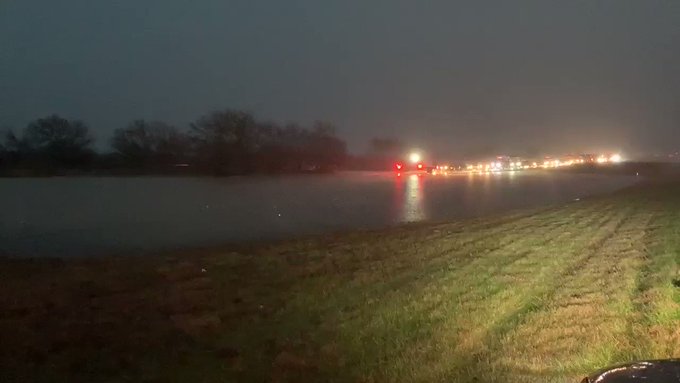
Farther north, hours of rain have left the northbound lanes of Highway 287 in Decatur, Texas, submerged. The flash flooding caught at least one car.
FLASH FLOODING near Decatur, TX has left the northbound lanes of Highway 287 submerged. At least one car is stuck in the flooding. @breakingweather @accuweather #TXWX
20 people are talking about this
5:30 p.m. CST Friday:
A new tornado watch has been issued from eastern Texas into southern Missouri that will continue into Friday night. This includes Shreveport, Louisiana, and Little Rock, Arkansas.
A tornado watch means that conditions are conducive for tornado development and that people in the area should closely monitor the weather. If a tornado warning is issued, this means that a tornado is imminent and people should seek shelter immediately.
4 p.m. CST Friday:
By 4 p.m. on Friday, just over 300 flights had already been canceled at Dallas-Fort Worth International Airport amid the severe weather, according to FlightAware. Another 344 flights at the airport were delayed.
2:53 p.m. CST Friday:
A radar-confirmed tornado is tracking toward Tahlequah, Oklahoma, moving to the northeast at 45 mph. People in the path of the this tornado need to seek shelter immediately.
The Tahlequah Daily Press reported that the tornado siren system was down at the time of the alert.
1 p.m. CST Friday:
A new tornado watch has been issued for part of eastern Texas, including the Dallas-Fort Worth Metroplex. Storms in this area could lead to significant disruptions to the Friday evening commute, especially for those flying into and out of airports being impacted by the storms.
10:43 a.m. CST Friday:
A Tornado Watch was released by the SPC for portions of central and eastern Oklahoma, northwest Arkansas, and southwest Missouri. As thunderstorms continue to intensify in central Oklahoma, the favorable tornadic conditions are expected to spread eastward.
According to AccuWeather Meteorologist Jesse Ferrell, this is just the third time since 1997 that a Tornado Watch has been issued by the SPC between Jan. 1 and Jan. 10.
7:42 a.m. CST Friday:
In the town of Leedey, Oklahoma, in the western portion of the state, golf ball-sized hail was reported. The 1.75-inch hail was the first reporting connected to the severe weather.
10 p.m. CST Thursday:
Texas Gov. Greg Abbott has announced in a press release that he has set numerous resources on standby to prepare for the impending severe weather. According to the Texas Division of Emergency Management, this includes "boats, helicopters, rescue teams, medical strike teams, additional law enforcement and volunteer organizations on standby across the region to ensure the state is ready to respond to any requests from local government officials."


No comments:
Post a Comment