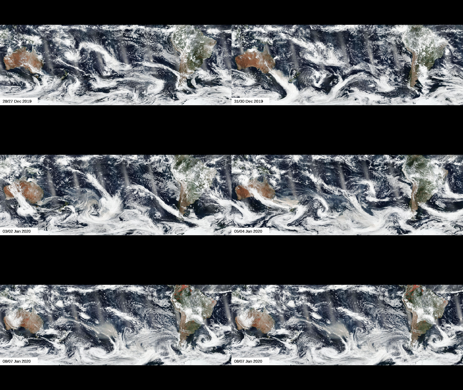
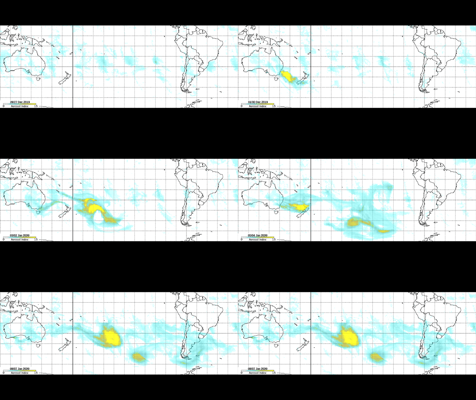
Wildfire smoke from the Australian bushfires has circumnavigated the Earth, according to data compiled by NASA satellites in orbit around our planet.
NASA scientists have been tracking the trajectory of the smoke and aerosols since late December using data from the NOAA/NASA Suomi NPP satellite, linking the devastation of the bushfires with "unprecedented" conditions such as searing heat and historic dryness.
These conditions have caused an abnormally large number of fire-generated thunderstorms known as pyrocumulonimbus events. Such thunderstorms have sent the bushfire smoke high into the atmosphere, helping to kickstart its journey around the world.
"Pyrocumulonimbus events provide a pathway for smoke to reach the stratosphere more than 10 miles in altitude," NASA wrote in a blog post last Thursday. "Once in the stratosphere, the smoke can travel thousands of miles from its source, affecting atmospheric conditions globally."

This smoke was lofted more than 9 miles high, NASA said. It drifted eastward across the South Pacific into New Zealand, where it caused severe air quality issues and visibly darkened mountaintop snow in the country about two weeks ago.
Andrew Mackintosh, head of the school of Earth, atmosphere and environment at Monash University and former director of the Antarctic Research Centre, estimated the dust could increase this season’s glacier melt in New Zealand by 20 to 30%.
“It is quite common for dust to be transported to New Zealand glaciers, but I would say that the amount of transport right now is pretty phenomenal – I don’t think I’ve ever seen anything like it,” Mackintosh told the Guardian on Jan. 1. “It is concerning to me to see so much material being deposited on the glaciers.”
By early last week, the smoke had traveled halfway around the world, detected in parts of South America, some 7,500 miles from its source in Australia. Skies turned hazy, causing colorful sunrises and sunsets.
Now, this week, that smoke has returned to Australia, completing its circumnavigation of the globe. The air quality in Australia was so poor Tuesday that professional tennis player Dalila Jakupovic collapsed during a qualifying match at the Australian Open.
NASA’s Goddard Space Flight Center in Greenbelt, Maryland, has been using all of the collected satellite data to create an ultraviolet (UV) aerosol index to track the smoke and aerosols that originated from the Australian bushfires.
"The UV index has a characteristic that is particularly well suited for identifying and tracking smoke from pyrocumulonimbus events: the higher the smoke plume, the larger the aerosol index value. Values over 10 are often associated with such events," said Colin Seftor, research scientist at Goddard. "The aerosol index values produced by some of the Australian pyrocumulonimbus events have rivaled the largest values ever recorded."

Astronauts aboard the International Space Station shared photos on Twitter showing their view of the smoke and ash as they orbited high above the Earth.
"An immense ash cloud covers Australia as we fly toward the sunset," Luca Parmitano, astronaut with the European Space Agency, tweeted on Monday.
More than two dozen people have been killed by the Australian bushfires, which have burned through more than 38,000 square miles and destroyed nearly 2,000 homes.
The Weather Company’s primary journalistic mission is to report on breaking weather news, the environment and the importance of science to our lives. This story does not necessarily represent the position of our parent company, IBM.
The Weather Company’s primary journalistic mission is to report on breaking weather news, the environment and the importance of science to our lives. This story does not necessarily represent the position of our parent company, IBM.

No comments:
Post a Comment