Updated Dec. 1, 2019 6:40 PM
Wintry weather created many hurdles for Thanksgiving travelers across the United States throughout the weekend as a dangerous storm moved eastward. It dumped heavy snow, freezing rain, sleet, ice and brought gusty winds.
The dangerous weather snarled travel and cut power to people across the central and northeastern United States throughout the weekend following Thanksgiving.
1/5
Thanksgiving travel in Minnesota, according to the Minnesota State Patrol. (Image via MnDPS_MSP)
Emergency personnel and officials warn travelers that even if roadways are open, that does not mean they are safe to travel on.
"If state and federal roads are passable does not mean county, township and municipal roads are going to be in the same condition," Minnesota Department of Transportation posted on Twitter.
Central United States
Nine people were killed and three others in critical condition after a plane crashed shortly after takeoff during a snowstorm in Chamberlain, South Dakota on Saturday afternoon.
Chamberlain, and much of South Dakota, was under a winter storm warning and experiencing near-blizzard conditions around the time of the crash on Saturday afternoon. Nearby in Pierre, South Dakota, wind gusts of 41 mph were observed around the time of the crash. Peter Knudson of the National Transportation Safety Board (NTSB) said that weather will be among several factors investigators will review, according to the Associated Press.
One of the highest wind gusts reported in South Dakota was observed in Edgemont, South Dakota, at 53 mph.
Nenderland, Colorado, was blasted with wind gusts as strong as a Category 1 hurricane on Saturday, measuring at 94 mph. Deep Creek BFA, Montana, measured wind gusts of 67 mph over the 36 hours preceding Sunday morning.

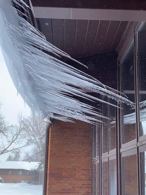
In Kimbell, Nebraska, icicles froze sideways amid high speed winds. The nearby city of Harrisburg, Nebraska, had recorded winds of 59 mph on Saturday. To the east of Kimbell, Sidney, Nebraska, recorded wind gusts of 67 mph Saturday.
Snow amounts continued to build for a few areas still within the tail end of the storm. A multitude of Minnesota’s roads were covered in snow as of Sunday afternoon, according to reports from the Minnesota Department of Transportation.
On Saturday, Duluth, Minnesota, set daily precipitation and snowfall records with 0.99 of an inch of precipitation and 14.5 inches of snow. By Sunday afternoon, a total of about 21.7 inches of snow had fallen in the city over the two days. With the snow still coming down, Duluth, Minnesota, has received 19.3 inches of snow as of early Sunday afternoon.
"As of early [Sunday], Duluth has seen near 20 inches of snow with wind gusts as high as 54 mph," AccuWeather Meteorologist David Samuhel said.
At the base of the Rocky Mountains, Lead, South Dakota, received 30 inches of snow with 3-5 foot drifts. Nearby, Central City also received 30 inches of snow.

Great Falls, Montana, finished the Meteorological Fall, which lasts from Sept. 1 to Nov. 30, with at least 60.4 inches of snow. That’s about twice the amount of the next highest years of 1985, which had 29.1 inches of snow and 1984 with 26.8 inches. Normal snowfall during the Meteorological Fall at Great Falls is 13.4 inches.
As the storm moves eastward, over 70,000 Michigan and Wisconsin residents were without power as of Sunday afternoon, according to PowerOutage.US.
Northeastern United States
The second part of the double-barreled storm unleashed heavy snow and caused difficult travel on Sunday for those traveling home from the Thanksgiving holiday over a large part of the northeastern United States, including some major cities.
A change from rain to snow during the day on Sunday made for slippery travel across the I-95 corridor as the storm traveled east from the Central U.S. into the Northeastern U.S.
A Delta Air Lines aircraft slid off a taxiway after landing at the Buffalo Niagara International Airport around 9 a.m. EST on Sunday morning, WKBW reported. The plane's wheel was stuck after it ran off of the taxiway; however, no injuries were reported.
"Freezing rain has caused icy roads and treacherous traveling conditions this morning across Pennsylvania and New York. Meanwhile, blizzard conditions continue to pound parts of Minnesota, Wisconsin, and Michigan," Samuhel said.
The Maryland State Highway Administration reported a 36-vehicle accident on I-68 W in Garrett County, Maryland at 3:30 p.m. EST on Sunday amid freezing rain. At least nine people have been injured.
511 Pennsylvania reported multiple crashes and multi-vehicle crashes on I-95 and US 1.
According to a National Weather Service report, icy conditions are to blame for numerous accidents on Interstate 84 in Pike County, Pennsylvania.
Part of Interstate 81 to the north of Binghamton, New York, near Castle Creek was closed because of icy conditions late Sunday morning.
Midland County dispatch, which is in the middle of the Lower Peninsula of Michigan, reported many large tree limbs and power lines down due to ice and severe weather. The Northeast shouldn't expect a break going into the workweek following the Thanksgiving holiday.
"As the snow winds down across the Great lakes, wintry weather will increase across the Northeast tonight and Monday," Samuhel said.
RELATED:
"Many places that are seeing ice and rain on Sunday, which will change to snow tonight and Monday. We have an AccuWeather Stormmax of 24 inches forecast in the Northeast by the time snow ends Tuesday morning," Samuhel said.
Download the free AccuWeather app to check the forecast in your area, as well as points along your travel route. Keep checking back on AccuWeather.com and stay tuned to the AccuWeather Network on DirecTV, Frontier and Verizon Fios.


No comments:
Post a Comment