The year 2019 had a dizzying array of tornadoes, floods, winter storms, cold outbreaks, heat waves and hurricanes, but some weather events this year have been downright bizarre.
After sifting through dozens of candidates, we narrowed our 2019 list of weirdest weather to a top 10 list, mainly for events that impacted the U.S. We do have a sizable list of honorable mentions below our top 10 list, simply because we love strange weather.
10. A Drought of Drought

Usually there's an area of drought in some part of the United States that is either already in place or growing by summer.
In 2019, however, there was a drought of drought.
By late April, drought covered only 2% of the area of the Lower 48 states, the least area of drought in the 19-year history of the weekly Drought Monitor analysis.
In mid-July, when searing heat is usually baking parched ground, the only significant areas of drought in the U.S. were in the Pacific Northwest and southeast Alaska, areas you typically think of as wet, not dry. It was one of the weirdest mid-summer drought maps we've seen.
This wasn't entirely good news. The first 11 months of 2019 was the wettest January-November period on record in the U.S., contributing to persistent flooding in the nation's heartland.
9. Strangest Wind Damage Report We've Seen
While monitoring the nation's weather, we often see National Weather Service reports of wind damage to trees, homes and power lines.
On the last day of April, we saw a report of strong winds unlike anything we had seen before.
The 45 mph estimated wind gust wasn't that notable. What made this stand out was the misfortune of someone in Tempe, Arizona, in the wrong place at the wrong time.
We can't imagine how awful that must have been. At the same time, we have to wonder if this is officially recorded as a weather-related injury.
8. One City, Twin Disasters at Once

One capital city suffered two separate weather disasters within hours.
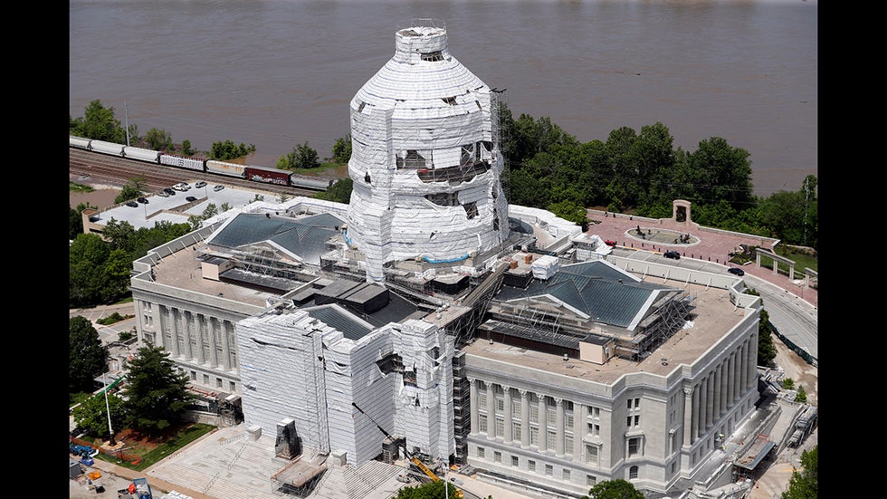
On May 22, Jefferson City, Missouri, Mayor Carrie Tergin issued a mandatory evacuation of all parts of the city north of the Missouri River. Torrential spring rain in northern Missouri and upstream in the Missouri River Basin was expected to swell the river to heights not seen since 1995.
Less than seven hours after the flood evacuation and state of emergency were declared, an EF3 tornado roared through just before midnight. Miraculously, nobody was killed, but damage was significant.
The Missouri River remained high and crested two weeks later at the highest level since the record Great Midwest Flood of 1993. It overtopped the levee at the airport and inundated the terminal with several feet of water.
7. Unharvested Corn and Snow Seen From Space

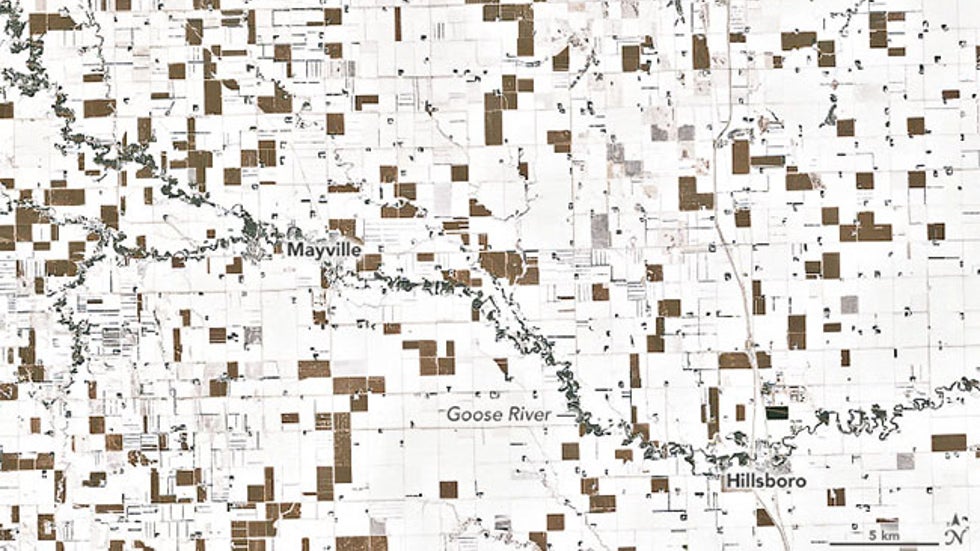
One early December image of snow cover in North Dakota was unlike most satellite images of snow on the ground.
Instead of a solid area of snow, the image above shows a patchwork quilt of snow and what appeared to be plots of land without snow cover.
According to Daryl Ritchison, director of the North Dakota Agricultural Weather Network, those brown parcels were unharvested corn. Ritchison, who tweeted a zoomed-out version of this satellite image, told NASA's Earth Observatory it doesn't mean there isn't snow on the ground in those fields, but instead the corn stalks are growing close enough to essentially shield the satellite from seeing snow cover in those unharvested fields.
North Dakota, Minnesota and Wisconsin each had their record wettest fall in 125 years, according to NOAA. The wet autumn left some farmers no choice but to leave corn and other crops standing much later than normal, either due to muddy or snowy fields or crops that hadn't dried sufficiently.
6. Dorian's Bizarre, Catastrophic Stall
Hurricane Dorian became the first Category 5 hurricane on record to make landfall on Grand Bahama Island, after it made multiple landfalls in the Abacos Islands of the northwestern Bahamas. Dorian tied the Florida Keys Labor Day 1935 hurricane for the highest wind speed of any Atlantic Basin landfall on record.
What truly made Dorian catastrophic was its bizarre stall. From Sept. 1 to 3, Dorian's eyewall lashed the northwest Bahamas for an unfathomable 52 straight hours. At the time, NOAA research meteorologist Patrick Marsh compared this to a strong tornado hammering one area for hours.
While over the northwestern Bahamas, Dorian was the slowest-moving major hurricane (Category 3 or stronger) on record in the Atlantic Basin, crawling at just 1 to 2 mph averaged over a 24-hour period, according to Robert Rohde, lead scientist at Berkeley Earth. The hashtag #1mph trended in Twitter, for a time.
It will take years for the northwest Bahamas to recover from Dorian, in part due to this terribly timed stall.
(FULL RECAP: Hurricane Dorian)
5. Tornado Survivor Doesn't Remember Being Tossed

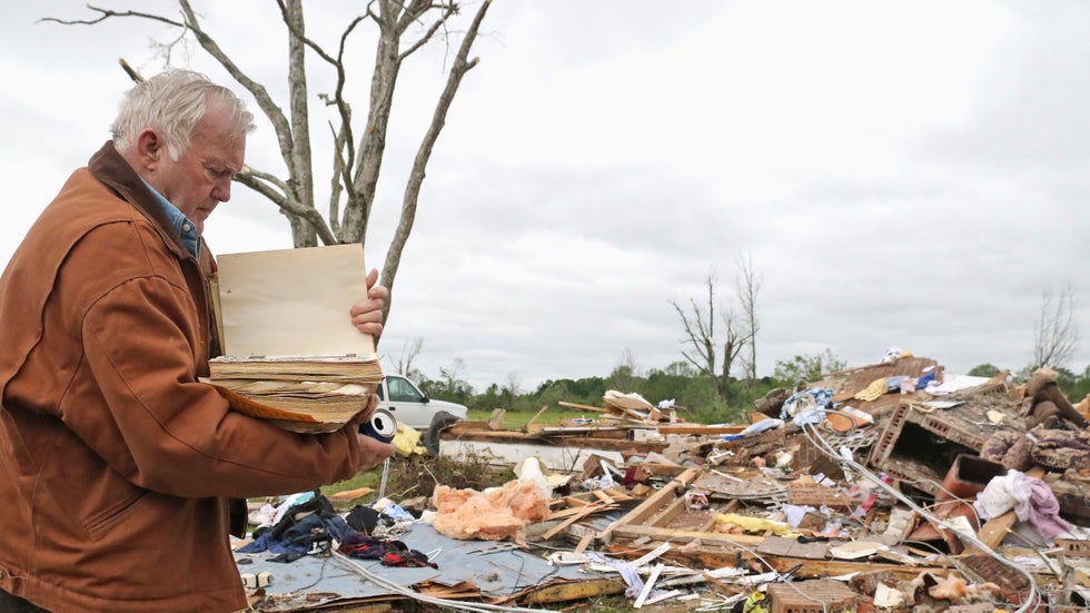
"I was asleep in my recliner...and next thing I knew I was in the yard."
This is what Robert Scott told The Weather Channel the morning after an EF2 tornado raked through Hamilton, Mississippi, before midnight on April 13, destroying the family's home.
Scott said he only remembers waking up after his wife, Linda, found him in the yard.
After neighbors helped him stand, he went to the hospital with scratches on his arms, hands and head.
The tornado claimed one life when a tree fell on a mobile home, according to the National Weather Service. Nineteen were injured.
"Just blessed to be alive," Scott later said, choking back tears.
(WATCH: Mississippi Man Survives Tornado)
4. A Deadly Hurricane That Never Made Landfall

Less than a month after Dorian's rampage, another hurricane rewrote the record books in a strange place.
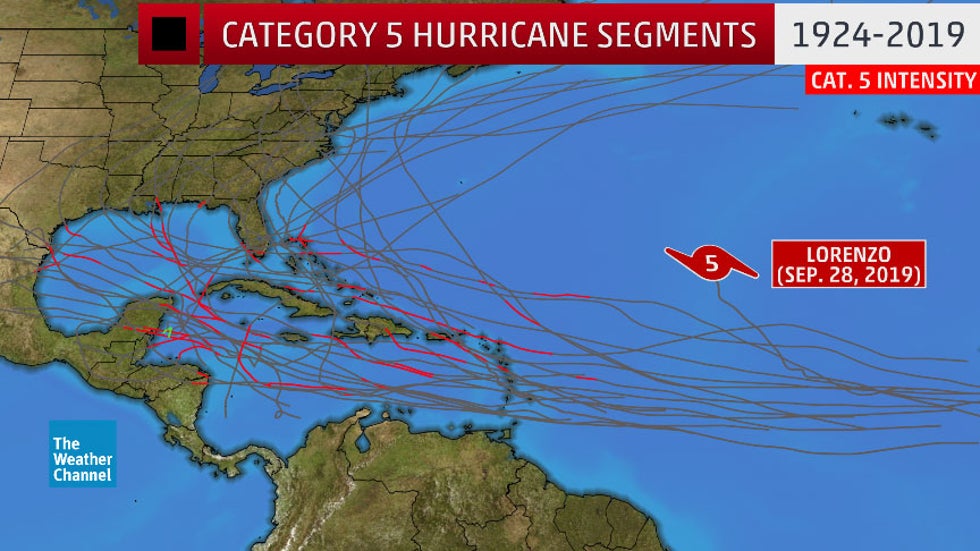
Hurricane Lorenzo became a Category 5 hurricane farther east than any other Atlantic hurricane in records dating to the 1920s. The plot of Lorenzo's position at Cat. 5 intensity relative to other Cat. 5 tracks is the textbook definition of an outlier.
But that wasn't Lorenzo's only oddity.
NOAA Hurricane Hunters, originally flying research missions into Lorenzo, flew two additional missions to support search and rescue efforts after a tugboat, the Bourbon Rhode, sank in the middle of Lorenzo as it was rapidly intensifying.
Eleven crew members of the tugboat died.
While Lorenzo remained at least 1,900 miles from the U.S. East Coast, rip currents and high surf generated by Lorenzo claimed eight lives along the East Coast.
As the National Hurricane Center's final report summed up, Lorenzo was the second deadliest hurricane of the 2019 Atlantic hurricane season, despite remaining far from the U.S. and Caribbean Sea and only brushing the Azores.
3. Lightning Near the North Pole
Location of lightning strikes detected by Vaisala's lightning detection network, denoted by the red circle near the top of the image above, on August 10, 2019.
In early August, the National Weather Service in Fairbanks posted an image in social media showing lightning strikes detected within 300 miles of the North Pole by a Vaisala lightning detection network.
It turned out there was another thunderstorm even closer to the North Pole earlier in the summer.
A later analysis by Vaisala reported in The Washington Post's Capital Weather Gang found a June 28 thunderstorm generated lightning 110 miles from the North Pole, the closest-known lightning flash to the pole in their dataset dating to 2012.
Arctic sea ice extent at the end of summer 2019 was the second-lowest in 40 years of satellite records, NOAA said in their 2019 Arctic Report Card.
Vaisala scientist Ryan Said speculated in the Washington Post that warm, humid air from areas with a lack of sea ice may have invaded areas near the North Pole, providing the instability for the thunderstorms.
You probably hadn't put the phrases "North Pole" and "thunderstorm" together in the same sentence until now.
2. Months-Long Flood Begins With Surge of Ice Boulders
A rare confluence of factors lead to an historic flood in the nation's heartland in March. In a few areas, the flood water never left.
Rapid snowmelt was followed immediately by heavy rain from a record-setting mid-March bomb cyclone. This unleashed rapid runoff into rivers previously frozen from exceptional February and early-March cold.
The ice-choked Niobrara River in northern Nebraska burst through and destroyed Spencer Dam and sent a wave of water and massive ice slabs into towns and fields.
The surge of ice slabs and water destroyed a restaurant in Niobrara and clogged bridges that weren't washed away along the river.
A dike failure along the Platte River even prompted the National Weather Service to evacuate its office west of Omaha, moving 100 miles away to Hastings, Nebraska.
But this wasn't nearly the end of the story.
A wet spring, summer and fall kept stretches of the Missouri River flooded much of the rest of the year, months longer than the most recent major flood in 2011.
It took until six days before Christmas for Nebraska to be 100% free of any National Weather Service flood warnings, watches or advisories, a streak that began just after Groundhog Day.
That said, some lowlands along the Missouri River in Iowa and Nebraska remain flooded due to a combination of damaged levees still unrepaired and upstream dam releases to make room for spring runoff.
Stretches of the Mississippi River also were in flood for months, setting flood longevity records from Louisiana to Iowa.
1. Abnormal Alaska
As of the time of this column, Alaska was on pace for its warmest year on record, dating to 1925, according to NOAA. That's attention-grabbing enough, but it masks some truly bizarre events throughout 2019.
One southeast Alaska town reached 70 degrees while it was still winter, a first such occurrence in state history. Spring ice breakup in mid-April was also record-early.
In late May, one of the wettest places in the U.S., southeast Alaska, was classified in extreme drought for the first time this century.
Summer records smashed in our 49th state included an all-time June record high in America's northernmost town, Anchorage's first-ever 90-degree high (on July 4th, no less) and the state's record warmest month in July.
Fall was no less strange.
Spring-like buds were seen on some plants in southern Alaska in early November. Anchorage set both daily record high temperature and snowfall records in one day in mid-November. Three weeks later, they soared above 50 degrees for the first time on record in December, a time of year in which the average high is only 25 degrees.
These bizarre events are a reminder Alaska is in the crosshairs of the planet's changing climate.
A decrease in Arctic sea ice extent is contributing to warmer Arctic air and raising the danger of coastal flooding from storms. Melting permafrost is wreaking havoc on some Alaskan towns, even prompting one town to relocate.
The Weird Honorable Mentions
There were many more strange things we saw in 2019. Here is just a sampling in chronological order.
-Houston rang in the new year with terrible air quality from holiday fireworks.
-Tucson, Arizona, kicked the year off with snow. Then it snowed again on the desert floor in late February.
-Thailand had its first January tropical storm landfall on record.
-Frozen methane bubbles were seen in a Canadian lake.
-Rare January tornadoes tore through parts of Ohio and Pennsylvania.
-Snow-covered Colorado farmland appeared 3D from above.
-Behold Maine's spectacular spinning ice disk.
-These ice formations looked like bats.
-Ever heard of sastrugi? These waves of snow were seen in New York state in January.
-Heavy snowpack + heavy rain = bales of hay in a Vermont river.
-While waiting for a multi-vehicle pileup to clear, these kids played hockey.
-If minus-56 degrees doesn't sound cold, how about a minus 82 degree wind chill?
-The "frozen pants trick" went viral during the record-setting late-January cold outbreak.
-Heavy lake-effect snow closed the Lake Effect Diner.
-A deadly Havana, Cuba, tornado was detected by a U.S. radar.
-Hawaii may have set a new all-time record low. Oh, and it snowed on Maui.
-Illinois, meanwhile, definitely did set a state cold record.
-A pair of lows off the East Coast were the eyes of a face.
-The hottest temperature so far south on Earth was recorded.
-Snow fell several times in Las Vegas.
-Siberia's snow was coal-contaminated, then green.
-A Category 5 formed in February.
-The South Pacific saw a "cracked" cyclone.
-Snowboarders made use of hail drifts in San Jose, California.
-A dust devil turned deadly.
-One Alaska town reached 70 degrees before winter ended.
-A Saudi desert was covered in hail.
-A frozen river was blown up to prevent flooding.
-A gustnado narrowly missed a school.
-Dust from over 1,000 miles away mixed with upper Midwest snow.
-A tornado narrowly missed an NWS Doppler radar.
-This is how some Texans protected their vehicles from hail.
-Chicago saw a Palm Sunday "near-blizzard", then a record late 2-inch-plus snow.
-A spectacular two-tone "dustnado" formed in Romania.
-Radar detected rain extinguishing a Florida wildfire.
-An airport cam captured lightning blowing a hole in an airport tarmac.
-It was Arizona's longest-ever ski season.
-Thundersnow shattered a May record in Duluth, Minnesota.
-Almost 300 tornadoes in two weeks in May was the most prolific U.S. tornado siege since the April 2011 Super Outbreak.
-A dam failure drained a Texas lake ahead of the Memorial Day weekend.
-One of the largest hailstones on record fell in Texas.
-Andrea's remnant was more fascinating in satellite imagery than it was as a subtropical storm.
-Four days from opening, this Colorado pool was a winter wonderland.
-Two tornadoes struck a Texas town within hours.
-A tornado was rated by damage to oil pump jacks.
-An EF3 El Reno, Oklahoma, tornado was very different from another infamous killer tornado six years ago.
-A tornado just missed Earth. Seriously.
-Tornado debris littered runways and taxiways at Kansas City International Airport, prompting a closure.
-Radar detected a ladybug swarm over Southern California and gulls near Duluth.
-A South Texas heat index broke a National Weather Service map.
-Pinky-toe size hail? Yep.
-One state's first tornado of 2019 rotated "backwards."
-Colorado cloud resembles fusilli pasta, or a drill bit.
-It was almost 80 degrees on Alaska's Arctic coast.
-Hurricane Barry's surge made a river flow backwards.
-Barry's weird loop was born from a July 4th Plains thunderstorm cluster.
-A tornado warning was issued for the "Frozen Tundra."
-Back-to-back derechos struck.
-West Virginia saw a "coal-nado."
-Kangaroos frolicked in Australian snow.
-A Montana hailstorm took a deadly toll on birds.
-Lightning vs. toilet: which one won?
-Colorado's tumbling mattresses were a sight on movie night.
-Hurricane Dorian created a floating forest.
-NOAA buoy served as a lifeboat.
-An incredibly wavy Alberta supercell impressed.
-Imelda's Flooded Interstate 10 brought déjà vu from Harvey.
-A record-smashing September snowstorm hit the northern Rockies.
-Heavy rain floated a Texas storm shelter.
-An October winter storm crumpled Manitoba transmission towers.
-Flames and smoke from a California wildfire emerged from sewers.
-The Red River of the North experienced a weird fall flood.
-Tree tumbling down a street in high winds were caught on video.
-Pablo became a hurricane between the Azores and Ireland.
-Thousands of apples floated down river after flooding wrecks an orchard.
-Two Arabian Sea tropical cyclones at once were a first in historical records.
-It hit minus 45 degrees in October.
-White Christmas? Try a white Halloween.
-Cows washed away in Hurricane Dorian were found alive.
-Fall cold snap left leaves on trees.
-Pennsylvania had severe thunderstorm warnings on December 1.
-A record dry streak ended with a record-wet November day.
-A Lake Superior sea stack was toppled by a storm.
-Three tropical cyclones lurked near Africa, and one intensified incredibly quickly.
-A beach turned black from wildfire ash.
-Earth saw its highest December temperature on record.
-Large hail fell in New England in December during an ice storm.
The Weather Company’s primary journalistic mission is to report on breaking weather news, the environment and the importance of science to our lives. This story does not necessarily represent the position of our parent company, IBM.
The Weather Company’s primary journalistic mission is to report on breaking weather news, the environment and the importance of science to our lives. This story does not necessarily represent the position of our parent company, IBM.

No comments:
Post a Comment