Weather conditions in the United States are turning calmer this weekend from coast to coast after what has been an active final week of October.
Consider the wide-ranging weather impacts we've seen in parts of the country during the past seven days:
- Three bouts of dangerous fire weather conditions in California since last Thursday.
- Two rounds of early season snow from the Rockies into the Plains and Midwest Sunday through Thursday.
- All-time October record cold in parts of the West and adjacent Plains.
- Severe thunderstorms and flooding rain in the East on Halloween.
- Wind damage from former Tropical Storm Olga in an area from southeastern Louisiana to the Ohio Valley.
The weather pattern across the nation won't have any of these kind of impacts through the weekend.
A broad southward plunge of the jet stream will be in place from the Northern Plains to the Great Lakes. Rippling through that band of strong upper-level winds will be a couple of weather disturbances.
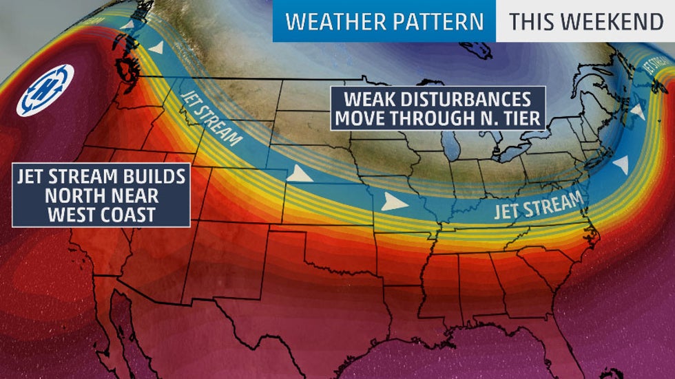
But those disturbances won't have much luck tapping into moisture from the Gulf of Mexico. That's because cool, dry air will cover much of the eastern two-thirds of the nation.
What that means is there will be little precipitation across the United States through the weekend. This kicked off Friday, when much of the nation was dry.
Saturday's forecast has just a few rain or snow showers in the Great Lakes, as well as scattered rain showers in parts of the Florida Peninsula. The rest of the country should remain dry and temperatures will generally be slightly below average.
On top of that, the bouts of strong winds in California will come to an end this weekend, providing relief to firefighters. Unfortunately, dry weather will continue because the jet stream will block any Pacific storms from providing rain.
The forecast on Sunday shows more widespread dry conditions. Only parts of the northern Rockies, Northern Plains and Great Lakes are forecast to see scattered rain and/or snow showers. A few thunderstorms may also rumble through South Florida.

It appears the general jet stream pattern expected this weekend may persist into at least the first half of November. That means colder than average temperatures are most likely to the east of the Rockies, according to the latest long-range temperature outlook from The Weather Company, an IBM Business.
For more details, click here.
A strong cold front will increase the chance for rain and snow across the central and eastern U.S. beginning midweek. There remains uncertainty in the details, but it looks like the quieter weather pattern will come to an end by mid-to-late week.
The Weather Company’s primary journalistic mission is to report on breaking weather news, the environment and the importance of science to our lives. This story does not necessarily represent the position of our parent company, IBM.
The Weather Company’s primary journalistic mission is to report on breaking weather news, the environment and the importance of science to our lives. This story does not necessarily represent the position of our parent company, IBM.


No comments:
Post a Comment