An impressive October snowstorm may bring dangerous blizzard conditions to the northern Plains through late this week while also blanketing locations such as the Denver metro with their first snow of the season.
The Weather Channel has named this system Winter Storm Aubrey.
Happening Now
Snow from this early season storm has spread into parts of the Dakotas and western Nebraska and continues to fall in some areas of Montana, Wyoming and Colorado. Snow will be heavy at times and snowfall rates will increase in the Dakotas into Thursday evening.

Around 2 feet of snow was reported in Pony, Montana and an observer just southwest of Helena, Montana, reported 18 inches of snow through mid-afternoon Wednesday. In south-central Montana, an observer at Lockwood reported 10 inches through Wednesday morning.
As of early Thursday, downtown Rapid City, South Dakota, measured just under 2 inches of snow and 7 inches was reported near Hill City, South Dakota.

The National Weather Service has posted winter storm warnings and watches in Wyoming, the Dakotas, northwestern Nebraska and northwestern Minnesota due to the threat of heavy snow in these areas.
Winter weather advisories are in place across the northern Colorado mountains and the adjacent Front Range, including Denver, for lighter snow amounts that could still cause travel problems.
Forecast Timing
Snowfall will spread on Thursday from the northern High Plains of the western Dakotas, Montana and Wyoming into Colorado, Nebraska and most of the rest of the Dakotas.
This includes Denver and Cheyenne, Wyoming, where temperatures will plunge from the lower 70s and lower 80s Wednesday into the 20s and 30s Thursday.

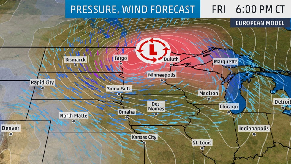
By Friday, strong low pressure will wrap up near the Canadian border in northern Minnesota, with wind-driven snow in the Dakotas and parts of Minnesota.

Crippling blizzard conditions are possible, according to the National Weather Service, in parts of central and eastern North Dakota and the Red River Valley Friday into early Saturday due to the combination of very heavy snow and strong winds, which will greatly limit visibility. Wind gusts over 50 mph are possible in some areas.

This combination of snow and wind could linger into Saturday or even Sunday from parts of Dakotas into Minnesota, northern Wisconsin and the Upper Peninsula of Michigan.
How Much Snow
Many areas of the northern Plains are likely to pick up at least 6 inches of additional snow.
More than a foot of heavy, wet snow is likely in parts of the Dakotas and far northwestern Minnesota. The exact placement and amounts of the heaviest snow in the northern Plains remain somewhat uncertain, dependent on the exact track of the strong surface low.
Denver and Cheyenne, Wyoming, could both receive a few inches of snow – their first of the season – but heavier totals are likely just west and northwest of those immediate metro areas.

Some lighter accumulations of wet snow, mainly on grassy areas, can't be ruled out as far south as northwestern Kansas, northern Iowa, southern Minnesota and northern Wisconsin, including the Twin Cities.
Typically, the season's first snow accumulates mainly on grassy areas, vehicle tops and roofs due to warm ground. However, these heavier accumulations will eventually lead to snow-covered roads and treacherous travel in the areas where heavy snow is forecast. There will also be reduced visibilities at times especially in rural, outlying areas.
The combination of strong winds, wet snow and trees still with leaves may lead to some downed trees or tree limbs and power outages in the northern Plains and along the Colorado Front Range corridor from Colorado Springs to Denver and northward.
As the National Weather Service in Grand Forks, North Dakota, noted, this northern Plains snowstorm will occur exactly one year after a somewhat similar storm dumped over a foot of snow in parts of eastern North Dakota in mid-October 2018.
This snowstorm has the potential to set October snowfall records in parts of the northern Plains. The following are the current three-day October snowstorm records that could be in jeopardy:
-Bismarck, North Dakota: 16 inches (Oct. 28-30, 1991)
-Fargo, North Dakota: 8.1 inches (Oct. 29-31, 1951)
-Grand Forks, North Dakota: 10.9 inches (Oct. 24-25, 2001)
-Jamestown, North Dakota: 4.9 inches (Oct. 29-31, 1951)
-Aberdeen, South Dakota: 16 inches (Oct. 21, 1906)
-Pierre, South Dakota: 7.2 inches (Oct. 30-31, 1943)
Snowstorm Recap So Far
Spokane, Washington, picked up 3.3 inches of snow late Tuesday. That tied as the city's second-snowiest October day in records dating to 1893.
Power outages and broken trees limbs were reported because of the heavy, wet snow in the Spokane area, as well as in adjacent parts of northern Idaho, according to the National Weather Service. More than 30,000 Avista Utilities customers in eastern Washington and northern Idaho were without power Wednesday morning.
Blowing and drifting snow was reported in parts of northern Idaho and western Montana. Whiteout conditions near Leadore, Idaho, Wednesday morning led to several vehicle slide-offs, according to a report received by the National Weather Service.
A 29-mile stretch of Interstate 15 in northeastern Idaho was closed in both directions midday Wednesday due to blowing snow, according to the Idaho Transportation Department.
The Weather Company’s primary journalistic mission is to report on breaking weather news, the environment and the importance of science to our lives. This story does not necessarily represent the position of our parent company, IBM.
The Weather Company’s primary journalistic mission is to report on breaking weather news, the environment and the importance of science to our lives. This story does not necessarily represent the position of our parent company, IBM.


No comments:
Post a Comment