Hurricane Dorian, a powerful Category 5 storm, roared over the Bahamas on Sunday afternoon making landfall on two different islands with punishing sustained winds of 185 mph and gusts that reached speeds of 225 mph.
Dorian proved to be a historic hurricane, the strongest ever during modern record-keeping to make landfall in the Bahamas and, with sustained 185-mph winds, it's now the second-strongest hurricane, by wind speed, ever recorded in the Atlantic basin. Dorian now stands behind only Hurricane Allen, the strongest storm ever recorded in the Atlantic basin. Allen thundered over the Gulf of Mexico in August 1980 and achieved sustained wind speeds of 190 mph before making landfall near the U.S.-Mexico border.
Hurricane Dorian made its initial landfall at Elbow Cay, Abacos, in the Bahamas. The eye of Dorian then made a second landfall on Great Abaco Island near Marsh Harbour in the Bahamas. Maximum sustained winds were 185-mph during each landfall. Gusts of 225, as AccuWeather Extreme Meteorologist Reed Timmer pointed out, were equivalent to the winds of an EF4 tornado.
Since 1851 the Treasure Cay area in the Abacos Bahamas has experienced three major hurricanes, all of which were Category 3 hurricanes, according to the NWS Charleston. Dorian, currently a Category 5, is the strongest by far to affect the area. Hurricane Andrew in 1992 is the only Category 5 hurricane to pass through the Bahamas.

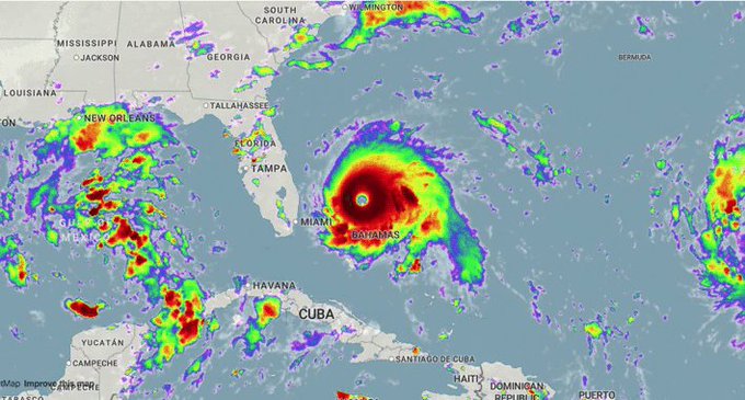
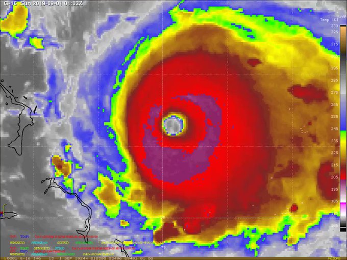
This satellite images shows Category 5 Hurricane Dorian making landfall across the northern Bahamas with maximum sustained winds of 185 mph on Sunday afternoon, Sep. 1, 2019. (NOAA/GOES-East)
In Freeport on Grand Bahama Island, residents hunkered down in a church that was being used for a shelter. Photos and videos surfacing on social media showed powerful winds whipping palm trees, flooding and some severe damage to residences. In addition to some places in the Bahamas seeing up to 24 inches of rain, severe storm surge could be devastating.
"With Dorian packing winds of 185 mph, life-threatening storm surge will also plague the northern Bahamas in the coming days. Storm surge across the northern Bahamas is expected to exceed 10 feet in some areas. This will pose a serious threat to both life and property across much of the northern Bahamas," AccuWeather meteorologist Brandon Buckingham said.
By late Sunday afternoon, Dorian had slowed to a crawl, swirling west at 5 mph, about 155 miles east of West Palm Beach, Florida. As the storm slowly drew nearer to Florida's Atlantic coast, the National Hurricane Center issued its first hurricane warnings and watches for parts of the Sunshine State.
John Raoux/AP
1/3
Matt Rohrer loads sandbags in the back of his vehicle for his home in preparation for Hurricane Dorian Friday, Aug. 30, 2019, in Flagler Beach, Fla. (AP Photo/John Raoux)
Meanwhile, the first mandatory evacuation orders were issued on Sunday for St. Johns County, St. Lucie County and Martin County and parts of Palm Beach County, including where President Donald Trump's Mar-a-Lago resort is located. The Miami Herald reported the Palm Beach evacuations are for those in low-lying areas and that the county began opening shelters on Sunday.
Florida Gov. Ron DeSantis suspended traffic tolls after the first evacuation orders went into effect at 1 p.m. "Hurricane Dorian is one of the strongest storms that's ever threatened Florida. If you live in a county with evacuation orders, please heed the call," DeSantis implored Floridians in a post on Twitter.
President Trump has also been issuing warnings about the power of Dorian. "It seems to be one of the biggest hurricanes we've ever seen, and that's a problem," Trump told reporters outside the White House on Sunday, discussing the changing forecast for where Dorian might make landfall in the U.S. "It seems to be going up toward South Carolina, toward North Carolina. Georgia's going to be hit. Alabama's gonna get a piece of it," Trump added. He posted a similar statement on Twitter as well.
The latest weather forecasts indicate that Alabama will not see any impacts from Dorian. The five-day forecast shows sunshine and temperatures in the 90s for Birmingham for the first week of September. But from Florida up through Georgia and the Carolinas, people were on edge. States of emergency have been in place for days.
While Dorian is a very powerful storm, AccuWeather meteorologists point out that it's small in size, something that could be critical depending on the track it takes as it approaches the southeastern coast of the U.S. Satellite images of Dorian still portray the hurricane as a relatively small feature. Hurricane-force winds only extend outward from the hurricane by about 30 miles, while tropical-storm-force winds extend outward from the center of the hurricane by about 105 miles -- a size that is roughly half of what is average for a hurricane, AccuWeather hurricane experts said.
Forecasters say Dorian could still deliver a glancing blow to the east coast of Florida, bringing hurricane conditions from Jupiter Inlet to the Volusia-Brevard County Line and tropical storm conditions up and down much of coast, even if its eye stays offshore and never makes landfall there. Beyond that, landfall is not out of the question for the Carolinas as Dorian slowly marches up the East Coast this week.
RELATED:
Hurricane Dorian may not make Florida landfall, but will eye Carolina coastState of emergency declared in 4 states; Dorian makes landfall in Bahamas as Category 5AccuWeather lowers its predicted total damage from Hurricane DorianCatastrophic Dorian unleashes record-setting wind gusts in northern Bahamas as storm slowly moves west
5:00 p.m. EDT Sunday:
Brevard County, Florida, is now under a hurricane warning, meaning hurricane conditions are expected within the next 36 hours.
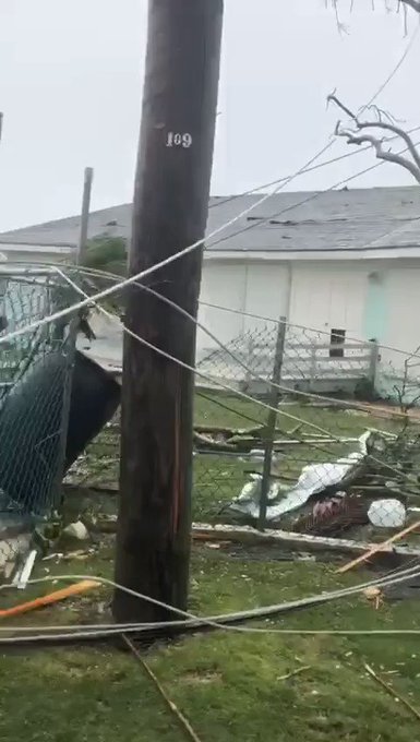
The full extent of the damage in the Bahamas is currently unknown, though there have been videos surfacing on social media of the insides of homes gutted, boats overturned in a sea of storm surge and houses with collapsed roofs after enduring one of the strongest storms of the Atlantic basin.
The National Hurricane Center estimated storm surge to be 18 to 23 feet above normal tide levels.
The damage looks akin to the wreckage left behind from a powerful tornado. Construction trucks are shown being employed in rescue operations. Photos from before the storm showed people hunkered down in churches, waiting for the worst to hit.
4:00 p.m. EDT Sunday:
Dorian continues to barrel across the northern Bahamas with maximum sustained winds holding at 185 mph. Storm sure is greater than 20 feet above normal tide levels in the hardest-hit areas, according the the National Hurricane Center.
Lightning has also continued in the eye of the hurricane, a signal that the storm may still be strengthening.
While the Bahamas are being battered by Dorian, people across eastern Florida are making their final preparations before the arrival of gusty winds and heavy rain from the storm. This includes placing sandbags and locking bridges and flood gates near the coast.
2:00 p.m. EDT Sunday:
The eye of Dorian made a second landfall on Great Abaco Island near Marsh Harbour in the Bahamas. Maximum sustained winds were 185-mph during landfall.
According to the National Hurricane Center, this is tied for the strongest Atlantic hurricane landfall on record with the 1935 Labor Day hurricane.
1:30 p.m. EDT Sunday:
Florida Gov. Ron DeSantis is suspending tolls ahead of Dorian.
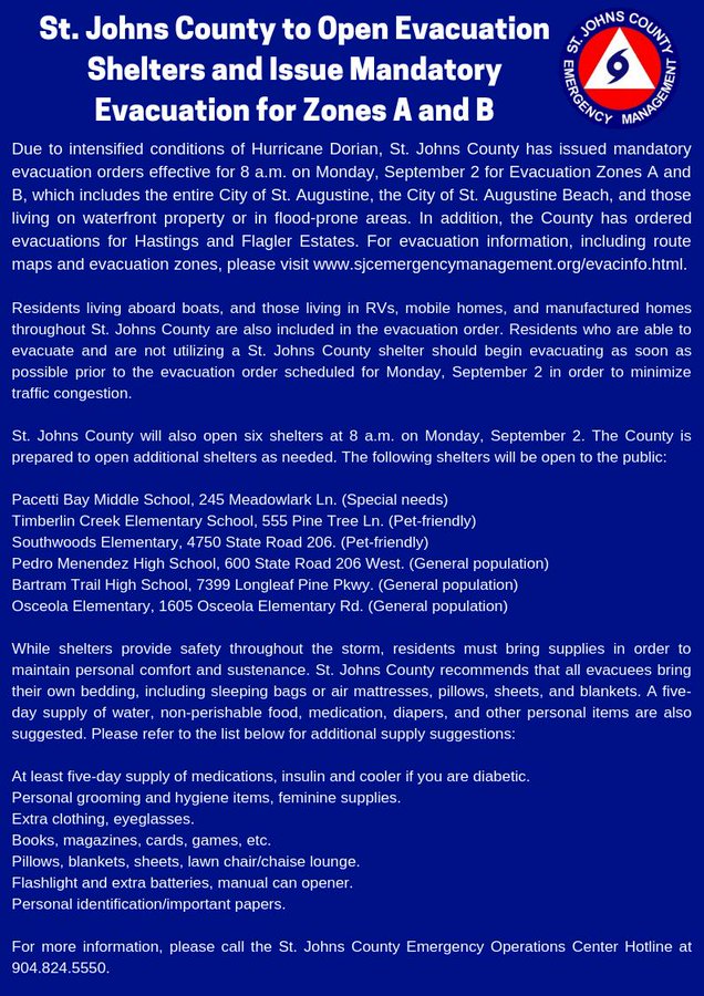
St. Johns County in St. Augustine, Florida has issued mandatory evacuation orders effective on 8 a.m. EDT Monday.
12:30 p.m. EDT Sunday:
Hurricane Dorian has made landfall with sustained surface winds of 185-mph at Elbow Cay, Abacos in the Bahamas.
Only one in the history of the Atlantic has achieved stronger top wind speeds than 185-mph, which was Hurricane Allen in 1980 packing 190-mph winds.


11:00 a.m. EDT Sunday:
Dorian is located about 205 miles east of West Palm Beach, Florida, and 20 miles east of Great Abaco island in the Bahamas. The hurricane has intensified and now has sustained winds of 180-mph, a dangerous Category 5.
Now at 180-mph, only four storms in the Atlantic have ever exceeded this wind speed, and only one since 2000, which was Wilma.
The outer rain bands of Dorian are moving over Great Abaco Island, and conditions will only get worse through the day Sunday and Monday.
Dorian is expected to slow its forward speed and turn north near or just offshore of Florida, Monday and Tuesday as a very damaging major Category 4 hurricane, with maximum sustained winds of at least 130 mph, if not higher.
10:00 a.m. EDT Sunday:
Dorian is closing in on Great Abaco Island, including Marsh Harbour and Hope Town. The Category 5 hurricane is still producing wind gusts well over 200-mph, similar to an EF4 tornado.
9:00 a.m. EDT Sunday:
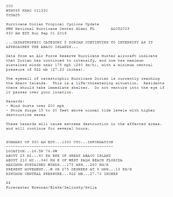
Dorian has sustained winds of 175-mph with wind gusts over 200-mph. According to the NHC, these extreme winds will continue for the next several hours. This puts Dorian in the top three Atlantic sustained winds storms. Since 2000 in the Atlantic, only Rita, Wilma, and Irma had higher sustained winds.
8:00 a.m. EDT Sunday:
Dorian is now a Category 5 hurricane, located about 225 miles east of West Palm Beach, Florida; 35 miles east of Great Abaco island in the Bahamas; was packing winds of 160 mph with higher gusts and was moving west at 8 mph.

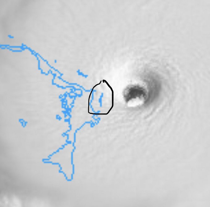
(Image via the Bahamas Department of Meteorology)
AccuWeather meteorologists pointed out satellite images of Dorian still portray the hurricane as a relatively small feature. Hurricane-force winds only extend outward from the hurricane by about 30 miles, while tropical storm-force winds extend outward from the center of the hurricane by about 105 miles. This is roughly half of what is average for a hurricane.
7:00 a.m. EDT Sunday:
Tropical storm warnings have now been issued for portions of Florida's east coast. A tropical storm warning is now in effect for north of Deerfield Beach to Sebastian Inlet, Florida, as well as north of Golden Beach to Deerfield Beach.
Dorian maintained Category 4 intensity overnight with maximum sustained winds of 150 mph.
6:00 a.m. EDT Sunday:
Dorian is located about 70 miles east of Great Abaco Island in the Bahamas.
Conditions will be deteriorating over the Abaco Islands during the next several hours, and then Grand Bahama Island later today, the National Hurricane Center said in a twitter post.
The storm's path has triggered Florida, Georgia, South Carolina and North Carolina to declare a state of emergency ahead of landfall.
5:00 a.m. EDT Sunday:
Dorian is about 255 miles east of West Palm Beach, Florida, and crawling closer at the sluggish pace of 8 mph. The storm maintains its Category 4 status with maximum sustained winds of 150 mph.








No comments:
Post a Comment