As tropical moisture continues to stream into the Deep South from the Gulf of Mexico, residents in portions of Louisiana, Mississippi and Alabama, will face the risk for flooding into Monday.

The persistently wet pattern observed across the portions of the South this past week came courtesy of a tropical wave that slowly tracked out of the Caribbean Sea and into the Gulf of Mexico. This system was unrelated to Invest 98L off the coast of Florida and Tropical Storm Dorian in the open Atlantic.
As the slug of moisture tracked near the Gulf Coast, a stalled out frontal boundary in place over the Deep South acted as a focal point for daily shower and thunderstorm activity.
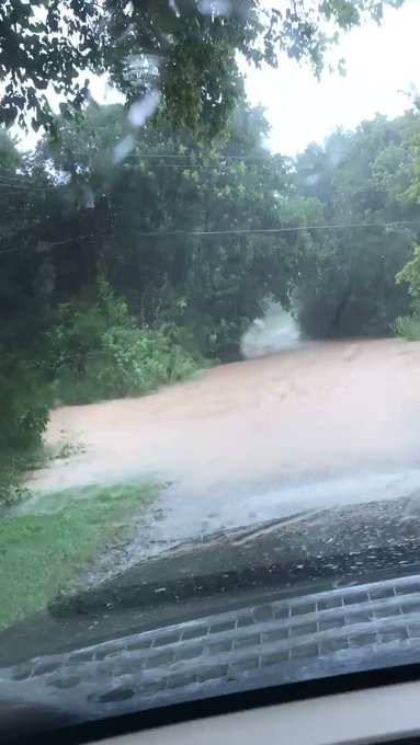
On Sunday around 5 p.m. CDT, the National Weather Service issued a flash flood emergency for the Shoals Metro area as floodwaters rose in northern Alabama. A social media user captured a video in Florence, Alabama, of cars attempting to cross flooded roads and floodwater at the doorsteps of houses.
According to the flash flood statement, the flooding is "an extremely dangerous and life-threatening situation." The flash flood warning will remain in effect for Florence and Muscle Shoals until 7 p.m. CDT.
Around 5:30 p.m., four to six inches of rain had already fallen, according to data from the statement.

The National Weather Service issued a flash flood emergency for Muscle Shoals and Florence, Alabama, on Saturday afternoon. About four to six inches had fallen over the area by 5:30 p.m. CDT, after the flooding had already started. (Twitter/@coachcos)
This surge of tropical moisture will continue to track northward early this week. As it does so, the risk for flooding will expand across a wider swath of the Deep South and into portions of the Tennessee River Valley.
Places such as Baton Rouge, Lafayette and Alexandria, Louisiana; Jackson and Tupelo, Mississippi; as well as Birmingham and Montgomery, Alabama, will all face the threat of tropical downpours capable of producing localized flooding through Tuesday.
"Motorists on interstates 10, 20, 22, 55 and 59 should exercise caution while driving through Monday as tropical downpours impact the area," AccuWeather Meteorologist Brett Rathbun stated.
RELATED:
The wet pattern will continue as a non-tropical storm system will impact the region Tuesday into Wednesday.
A storm system that will be responsible for triggering severe thunderstorms across the Plains and Midwest into Monday is expected to continue a track into portions of the lower Mississippi Valley by Tuesday. An associated cold front will act as a focal point for showers and thunderstorms as it tracks through, possibly producing localized severe weather as well as flooding downpours.
Better news is on the horizon for folks who want drier weather in the forecast. In the wake of the frontal boundary, many areas in the middle and Deep South can expect dry weather and decreased humidity Wednesday through Friday.
Places such as Nashville and Memphis, Tennessee, will have the arrival of drier and less humid weather by Wednesday. Dry and settled conditions are expected to extend right down to the Gulf Coast by Thursday, as much of the Deep South will dry out.
Friday may continue the stretch of largely dry weather across the Deep South once again.
As residents of the Deep South look ahead to Labor Day weekend, all eyes will switch to monitoring the tropics, more specifically the exact path of Tropical Storm Dorian.
Download the free AccuWeather app to stay alert of tropical and severe weather threats. Keep checking back for updates on AccuWeather.com and stay tuned to the AccuWeather Network on DirecTV, Frontier and Verizon Fios.


No comments:
Post a Comment