Barry is moving inland, producing a significant flood threat across the lower Mississippi Valley.
The storm made landfall on Saturday morning as a Category 1 hurricane, near Intracoastal City, Louisiana, but quickly weakened to a tropical storm several hours later.
There have been multiple reports of water overtopping levees, prompting additional mandatory evacuations in St Mary and Terrebonne parishes.
Scroll down to read real-time updates from July 12-13. For continued live updates of Barry's impacts across the Gulf Coast, click here.

The flood wall near the Long-Allen Bridge in Morgan City, La., continues to protect residents and area businesses as the waters rose in the Atchafalaya River, Friday, July 12, 2019. (AP Photo/Rogelio V. Solis)
RELATED:
Barry weakening does not diminish risk for up to 2 feet of rain in lower Mississippi Valley
What the ‘big, big lessons’ learned from Hurricane Katrina mean now for New Orleans as Barry moves inland
Barry designated level 2 on AccuWeather RealImpact Scale
Barry weakening does not diminish risk for up to 2 feet of rain in lower Mississippi Valley
What the ‘big, big lessons’ learned from Hurricane Katrina mean now for New Orleans as Barry moves inland
Barry designated level 2 on AccuWeather RealImpact Scale
10 a.m. CDT Saturday: Barry is now a Category 1 hurricane as it approaches the Gulf Coast. The main threats are flash flooding, damaging wind gusts, and a few possible tornadoes.
9:40 a.m. CDT Saturday: There have been multiple water rescues this morning. The United States Coast Guard rescued at least a dozen people along Island Road in Terrebone Parish.
Four people and a cat were rescued by a MH-65 Dolphin helicopter and transported from Island Road to Houma, Louisiana, according to WKRG.
#USCG crews rescued multiple people from flooded areas this morning. Our ability to conduct rescues diminishes as the storm approaches and may be non-existent at times. Evacuate flood prone areas if safe to do so. #Barry #BarryResponse #USCGBarryResponse

See USCG Heartland's other Tweets
8:50 a.m. CDT Saturday: Barry is set to make landfall in the next few hours, close to Marsh Island, Louisiana. Enhanced storm surge is possible just east of center south of the Baldwin area.
The Lafourche Parish Sheriff's Office shared a video on twitter near the Lafourche levee showing Louisiana Highway 1 underwater.
VIDEO: View of LA 1 from the South Lafourche Levee. Video provided by Golden Meadow Police Chief Reggie Pitre. #TropicalStormBarry

278 people are talking about this
7:40 a.m. CDT Saturday: All inbound and outbound flights to Louis Armstrong New Orleans International Airport have been canceled as as of 7 a.m. CDT. Travelers are urged to check with their airlines for updates on the status of their flights.
7:00 a.m. CDT Saturday: More than 63,000 customers are without power, which is more than double the amount of outages from Friday night.
A moderate to high risk of excessive rainfall exists across a large portion of the New Orleans region today and tonight. Rainfall totals of 10 to 20 inches will be possible.
At 6 a.m. CDT, the curfew was lifted for the City of Thibodaux, Louisiana; however, officials are encouraging residents to stay off of the roads. Curfew continues for all other areas of Lafourche Parish until 8 a.m. CDT.
“Overnight deputies cleared several trees from the roads and there is much debris on the highways. Over 5,000 residents are without power this morning. We expect strong winds to continue today and torrential rainfall will begin to fall through Monday,” the Lafourche Parish Sheriff's Office said on Twitter.

NEW: river flooding in The Atchafalaya River in Morgan City, LA as Tropical Storm Barry looms offshore! Stay tuned to @accuweather for live updates

92 people are talking about this
6:00 a.m. CDT Saturday: WWL-TV reports that the US Coast Guard is working to rescue 12 people from a remote island in the Terrebonne Parish area in Louisiana.
Louis Armstrong New Orleans International Airport announced on Twitter that all Delta flights have been canceled on Saturday due to Barry. Frontier, JetBlue and Southwest Airlines have also canceled all Saturday flights to and from the airport.
According to NWS Mobile, waves heights of more than 10 feet have been observed by a buoy located 44 nautical miles southeast of Mobile, Alabama.
5:25 a.m. CDT Saturday: The rainbands of Barry are moving onshore in Louisiana. Landfall is expected to occur later today, according to the National Hurricane Center.
Power outages continue to rise across Louisiana, according to PowerOutage.us. More than 58,233 customers are without power, which is roughly 12,000 more than one hour ago.
A 3-foot storm surge was reported in the past hour by a National Data Buoy Center Coastal-Marine Automated Network 14 miles southeast of Burns Point, Louisiana.
"As storm bands increase throughout the morning, we remind residents to report any street flooding to 911," New Orleans Mayor LaToya Cantrell said.
Mayor Cantrell urges residents to stay safe, stay inside, do not move any barricades and stay ready.
4:00 a.m. CDT Saturday: The outer reaches of Barry are being felt across southeastern Louisiana and coastal Mississippi and Alabama at this hour.
A special marine warning is in effect for the coastal waters from Pensacola, Florida, to Pascagoula, Mississippi. The NWS said strong thunderstorms moving onshore could produce waterspouts and wind gusts to 46 mph.

This radar image from early Saturday morning shows Barry's outer rain bands moving into southeastern Louisiana and coastal Mississippi and Alabama.
The National Hurricane Center stated that Tropical Storm Barry is moving west-northwest at 5 mph in their 4:00 a.m. CDT
2:50 a.m. CDT Saturday: The number of customers without power is rising across Louisiana, according to PowerOutage.us. Over 46,000 customers are without power, which is up from 28,000 earlier Friday night.
Bands of heavy rain and thunderstorms are moving onshore across southeastern Louisiana and coastal Mississippi and Alabama. These bands can contain very heavy downpours, gusty winds and also the risk of waterspouts and tornadoes.
1:20 a.m. CDT Saturday: As Barry's rainbands begin to move onshore, the risk of spin-up tornadoes is increasing. A tornado warning has been issued for southwestern St. Bernard Parish and northwestern Plaquemines Parish in southeastern Louisiana until 1:30 a.m. CDT.

Tornado Warning including Port Sulphur LA, Pointe à la Hache LA, Hopedale LA until 1:30 AM CDT

18 people are talking about this
12:50 a.m. CDT Saturday: The National Weather Service office in New Orleans told residents to not let their guard down even though the worst impacts from Barry are slow to move onshore.
"We are sensing a great deal of impatience with the onset of impacts from Tropical Storm Barry," they said on Twitter. "Plenty of very heavy rainfall parked off the coast [is expected] to move through the area throughout the day Saturday into Sunday. Be patient and DO NOT drop your guard."

While the radar imagery is fairly quiet with the worst of Barry's rain offshore as of 12:50 a.m. CDT Saturday, conditions are expected to deteriorate across Louisiana throughout the day on Saturday.
11:20 p.m. CDT Friday: AccuWeather Extreme Meteorologist Reed Timmer reports that water is rising rapidly off Island Road in Terrebonne Parish, Louisiana, as Barry's storm surge begins to move in. Timmer estimates the water is 3-4 feet along part of the road.
"AccuWeather meteorologists expect a maximum storm surge of 3-6 feet mostly along and just to the right of the storm's path," Kottlowski said.
The greatest storm surge will impact most of the central and southeastern coastal areas of Louisiana.

Storm surge much higher now on Island Road in TerreBONNE Parish as the tide is now working in concert with wind. Water likely 3-4 feet deep just south down this road. Time is 10:00 pm @breakingweather @accuweather
130 people are talking about this
10 p.m. CDT Friday: Curfews will be going into effect now for Terrebonne Parish, the City of Thibodaux, Lafourche Parish and other communities. Please stay off the roads and take shelter for your safety and the safety of emergency personnel. In Louisiana alone there have been over 20,000 customers without power according to PowerOutage.US.
Barry continues to crawl at 3 mph for the Louisiana coastline as a tropical storm, hindered by dry air. When maximum sustained winds of 74 mph or greater are detected, the storm will be classified as a hurricane. But for now, the maximum sustained winds sit at 65 mph.

We are closely monitoring #TSBarry Resident safety is our top priority. @NOLAready reports gusty winds and light rains moving through the city now. Heavy rain will fall later tonight and tomorrow. Remember do not drive through flooded waters or move barricades for your safety.

67 people are talking about this
8 p.m. CDT Friday: New Orleans is now under a shelter-in-place orderand the Regional Transit Authority services are suspended in preparation for Tropical Storm Barry.
Curfews will be going into effect soon for Terrebonne Parish, the City of Thibodaux, Lafourche Parish and other communities at 10 p.m. CDT.
7 p.m. CDT Friday: Southwest Airlines has joined the list of airlines that has canceled flights in and out of New Orleans for Saturday, July 13. Cancellations and delays at the airport could continue through the weekend and into the start of next week due to Barry. The complete list of travel advisories at the New Orleans airport can be found here.
The FAA has also issued a NOTAM for drone pilots across much of southern Louisiana and Mississippi through Sunday, July 14. "Avoid flying in the area unless conducting an active disaster response or recovery mission," the FAA said on their website.
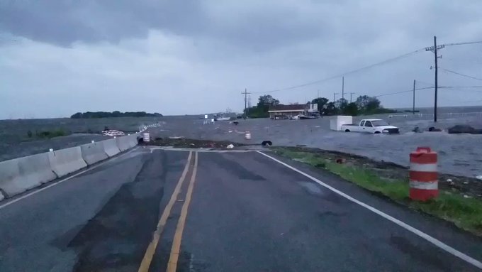
3:20 p.m. CDT Friday: Although the center of Barry and the storm’s heaviest rain is still over the Gulf of Mexico, some roads near the coast of Louisiana are already impassible due to flooding storm surge.
The City of New Orleans has called for voluntary evacuations for people living outside of areas protected by the levees. Those that plan on evacuating should do so in the next few hours. Once the heavy, flooding rain starts, it will be too late to evacuate.

UPDATE: storm surge now making many roads south of Hwy 665 impassable including Island Rd in Terrebonne Parish, LA well ahead of Tropical Storm #Barry @breakingweather @accuweather
401 people are talking about this
The Rolling Stones have officially postponed this weekend’s concert in New Orleans' Mercedes-Benz Superdome from Sunday to Monday due to Barry. There is the potential for the date to get moved again due to the lingering effects of Barry.
1 p.m. CDT Friday: Residents and visitors in New Orleans only have a few more hours to make their final preparations ahead of Barry's arrival. Officials have announced that everyone in the city needs to start sheltering in place by 8 p.m. CDT Friday.
Grocery stores in New Orleans are sold out of items such as food and bread as people flock to the stores to stock up ahead of Barry and the flooding that will linger in the wake of the storm.
Some flights scheduled at New Orleans Airport this weekend are already being canceled. Airlines are issuing travel advisories due to Barry. People planning to fly this weekend in and hour of the region should check with their airline before heading to the airport.
Airlines have begun issuing travel advisories for #TSBarry. Travelers may be able to change flights if travel is planned during this weather event. Links to airline travel advisories can be found at flymsy.com/traveladvisori….

See New Orleans Airport's other Tweets


No comments:
Post a Comment