By Brett Rathbun, AccuWeather meteorologist
Following multiple rounds of severe thunderstorms and flooding already this week, more heavy rain and thunderstorms are in store for the south-central United States into this weekend.
"Portions of the south-central U.S. have been inundated with flooding rain, large hail and continuous lightning this week, and the threat is not yet over," AccuWeather Meteorologist Brandon Buckingham said.
The fire hose of moisture from the Gulf of Mexico will trigger additional rounds of flooding rainfall from eastern Texas into the Tennessee Valley this weekend.
Louisiana Gov. John Bel Edwards has declared a state of emergencydue to the severe weather that impacted the state earlier this past week and the flooding rainfall that has followed.

"Copious amounts of Gulf moisture will be drawn northward into an already waterlogged Deep South," Buckingham said.
Houston and Beaumont, Texas; Lake Charles, Alexandria and Baton Rouge, Louisiana; and Jackson, Mississippi; could face widespread flooding problems by the end of the weekend.
Leftover moisture and a lingering frontal boundary will aid in the redevelopment of multiple rounds of showers and thunderstorms from eastern Texas to the lower Mississippi Valley, central Gulf Coast and Tennessee Valley this weekend.
A few severe thunderstorms may erupt around Louisiana on Saturday.
"There could be a couple of waterspouts near the Gulf Coast each day through this weekend," AccuWeather Senior Meteorologist Alex Sosnowski said.. "So, marine and coastal interests should exercise caution."
RELATED:
Severe thunderstorms batter Houston, southeastern Texas with baseball-sized hail and flooding rainfall
Tornadoes, damaging wind and deadly floods leave trail of destruction across south-central US
Real-time severe weather reports from May 7-8
Who will get rain and who will have sunshine this Mother's Day weekend?
It may only take 1 or 2 inches of new rainfall to trigger flooding across the region.
An AccuWeather Local StormMax™ of 8 inches will be possible across southeastern Texas and portions of Louisiana this weekend.
River flooding is expected to occur by this weekend and may continue into June as floodwaters in rivers farther north travel southward along the Mississippi River. Never drive through a flooded roadway. Turn around and find an alternate route.
Drier weather will attempt to squeeze into the region Sunday and early next week; however, the threat for more rain and thunderstorms will return for a few days next week.
Unfortunately, AccuWeather predicts more flooding events to occur into the upcoming summer.
Recap of severe weather events across the south-central United States this week
This was a busy week of severe weather that marched across the south-central U.S.
Monday, May 6
Severe thunderstorms focused across Kansas, bringing primarily large hail and damaging winds. Hail up to baseball size was reported near McPherson, Kansas.
Tuesday, May 7
Tuesday featured severe weather from western Texas into south-central Kansas.
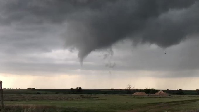
There were numerous reports of tornadoes across the northern Texas Panhandle. As of early Friday morning, the National Weather Service in Amarillo, Texas, has confirmed six tornadoes across their coverage area, all rated EF0 on the Enhanced Fujita Scale.

The heavy rainfall from these storms forced a large portion of Interstate 35 in south-central Kansas to close due to flooding.
Outside of the severe weather area, a round of thunderstorms produced between 3 and 10 inches of rain across southeastern Texas. Sugar Land, Texas, a suburb of Houston, picked up nearly 10 inches of rain.
Wednesday, May 8
The ongoing severe event continued to produce heavy rain and flooding across central Oklahoma, including Oklahoma City.
Just before midnight local time, The National Weather Service in Norman, Oklahoma, confirmed a couple of tornadoes across the region. An EF2 tornado tracked from north of Hobart to Rocky, Oklahoma. An EF1 tornado moved through Newkirk, Oklahoma.
An additional four tornadoes were reported: two in Brazos County, Texas, and the other two across Louisiana.


Bad damage in Longview, TX with large trees down and some minor structural damage from line of storms with embedded tornadic circulations passed through. Shared with my by a friend who reports the hospital there is still on generator power @accuweather @breakingweather
57 people are talking about this
The flooding turned deadly in Austin, Texas, after a man believed to be in his 50s was swept away by raging floodwaters.
Thursday, May 9
A thunderstorm complex developed across southeastern Texas early Thursday evening, producing hail as large as baseballs, gusty winds and flooding rainfall. Houston was hit very hard.

Roads were flooded in Houston on Thursday evening. This photo was taken on Texas Avenue under the 59 underpass in downtown Houston. Residents were attempting to make it home following the Houston Astros baseball game at Minute Maid Park. (Twitter/Morgan H)
Rainfall totals of 3 to 6 inches fell across southeastern Texas and southwestern Louisiana during Thursday night.
Several roads remain closed in and around Houston and may not be reopened until later in the weekend. Rivers and streams are already near or over their banks.
Earlier on this day, torrential rain inundated the Greenville, Mississippi, area, which caused significant flooding of businesses and prompted water rescues.
During Thursday midday, a flash flood emergency was declared in Jackson, Mississippi, where up to 3 inches of rain fell in only a few hours.
Download the free AccuWeather app to see the temperature forecast and the prospect for rain in your area. Keep checking back for updates on AccuWeather.com and stay tuned to the AccuWeather Network on DirecTV, Frontier and Verizon Fios.


No comments:
Post a Comment