By Amanda Schmidt, AccuWeather staff writer
The Great Lakes are one of the world’s largest surface freshwater ecosystems, which encompasses 84 percent of North America's surface fresh water. Their shorelines stretch around 10,000 miles along their borders in Canada and the United States. These five enormous lakes have significant cultural, economic and environmental impacts throughout North America.
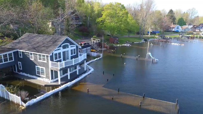
These marvelous lakes change with the seasons and are largely affected by current weather patterns, rapidly freezing during the polar vortex invasion this January into February and then undergoing a dramatic transition later as the weather warmed and the ice melted. The latest weather patterns, including the higher-than-average precipitation, put these lakefront communities in a precarious situation, as lake water levels are expected to reach historic highs.
Communities surrounding the Great Lakes are preparing for the worst, as the bulging lakes are forecast to set water level records over the next six months. Both state and local government officials have addressed the flood threat. New York Gov. Andrew Cuomo traveled to a lakefront community in western New York earlier this week to survey the flood risk.
The Great Lakes basin has received about 20 percent above-normal precipitation so far this month, according to the latest forecast from the U.S. Army Corps of Engineers last week. By mid-May, precipitation totals were up to twice as much as normal for this time of year in some areas.
The latest forecast said that the persistent wet conditions and high stream flows this spring have resulted in a rapid rise in lake levels. The daily levels of lakes Superior, St. Clair and Erie were all above record high monthly mean levels for May as of the middle of the month and, the Army Corps of Engineers warned in a statement earlier this month, could break records set in the 1980s and 1950s.

"Be careful around the lake today, wave heights are creeping up as wind gusts approach 45-50 mph," the National Weather Service (NWS) office in Duluth, Minnesota, said on Twitter on Sunday, May 19, 2019. Lake Superior water levels are currently above average. (Twitter photo/@NWSDuluth)
Over the last month, lakes Superior, Michigan, Huron, St. Clair (which is part of the Great Lakes system, but not itself on of the Great Lakes) and Erie have risen 7 to 10 inches, while Lake Ontario has risen 23 inches. Lakes Superior, Michigan and Huron are 10 and 9 inches higher than they were at this time last year.
Lakes St. Clair and Erie are both 6 inches higher than last year, and Lake Ontario is 17 inches higher than its level of one year ago, according to the forecast. Lakes Superior, Michigan and Huron are forecast to be 3 inches higher, while Lake St. Clair and Erie are forecast to be within an inch of current levels. Lake Ontario is forecast to be 5 inches higher than it is currently.
"These are a measure of the average surface of the entire lake," said Keith Kompoltowicz, chief of watershed hydrology at the U.S. Army Corps of Engineers, Detroit District. "We use a network of gauges around each lake."
At Lake Superior, for example, the U.S. Army Corps of Engineers use five water-level gauges around the perimeter of the body of water to come up with a lake-wide elevation.
RELATED:
Great Lakes undergo incredible transformation in less than 1 month
AccuWeather predicts smaller corn and soybean yields in 2019 as wet weather persists
Memorial Day outlook: Storms to threaten central, western US; Record heat to grip South
Great Lakes undergo incredible transformation in less than 1 month
AccuWeather predicts smaller corn and soybean yields in 2019 as wet weather persists
Memorial Day outlook: Storms to threaten central, western US; Record heat to grip South
"The coastal flooding will occur when wind or storm systems cause very localized water level rises at a specific location," Kompoltowicz said. For example, in western Lake Superior near Duluth, Minnesota, any sort of an easterly wind will push more water toward that side of the lake and may cause of coastal flooding.

A satellite image captured by NASA showing the Great Lakes in mid-May 2019, at which time the lakes were facing potential historic water levels. (NASA / MODIS)
This is "a Great Lakes-wide problem," Kompoltowicz said. When spring storm systems come through or very strong onshore winds kick up, significant erosion and/or flooding at those specific locations will be likely.
"This is a situation where it's impacting all of the shoreline regions of the Great Lakes, but not at the same time," Kompoltowicz said.
There may be an instance of coastal flooding in the western basin of Lake Erie one day, then the wind shifts and there is coastal flooding in the eastern basin of Lake Erie, depending on the current conditions.

Mounds of ice collect along the Lake Erie shore at Hoover Beach, in Hamburg, N.Y., Monday, Feb. 25, 2019. High winds howled through much of the nation's eastern half for a second day Monday, cutting power to hundreds of thousands of homes and businesses, closing schools, and pushing dramatic mountains of ice onto the shores of Lake Erie.(AP Photo/Carolyn Thompson)
Typically, lake levels are at their highest in the spring due to melting snow and numerous rain storms. By the fall, the levels are usually much lower due to less uniform rainfall and high evaporation, according to AccuWeather Senior Meteorologist Brett Anderson.
"Due to the high to record high water levels this year, we are mostly concerned about a significant increase in erosion along the lakeshores, especially during storms," Anderson said. "There may also be an increase in property damage and losses due to the high water. Insurance rates may trend higher due to this."
Over the past 50 years or so, there has been fairly high variability from year to year and decade to decade over most of the lakes. One year can be well below normal, while the next year can be well above normal.
"However, I did notice a distinct upward trend in lake water levels on Lake Erie over the past several decades," Anderson said.
RELATED:
Memorial Day outlook: Storms to threaten central, western US; Record heat to grip South
AccuWeather predicts smaller corn and soybean yields in 2019 as wet weather persists
Great Lakes undergo incredible transformation in less than 1 month
Memorial Day outlook: Storms to threaten central, western US; Record heat to grip South
AccuWeather predicts smaller corn and soybean yields in 2019 as wet weather persists
Great Lakes undergo incredible transformation in less than 1 month
Cuomo traveled to Olcott, located in Niagara County in western New York, on Monday to meet with local officials about potential historic flooding. Cuomo declared a state of emergency for the eight counties impacted by potential Lake Ontario flooding. The counties included in the state of emergency are Niagara, Cayuga, Jefferson, Monroe, Orleans, Oswego, St. Lawrence and Wayne.
Cuomo did not order the evacuation of residents, but he warned that widespread flooding could hit lakefront communities like it did two years ago.
"We are preparing now for the reoccurrence of the 2017 flooding situation, which as people remember was devastating and caused a lot of damage and a lot of hardship for thousands of New Yorkers. We're talking about the entire shoreline of Lake Ontario, so it's hundreds of miles of New York State property," Cuomo said.
Lake Ontario is approaching a record high set in 2017. Cuomo said waves could lead to flooding and damage in the same places that suffered two years ago.
"If you are a homeowner or a business that was damaged in 2017, prepare for a redux of the same situation," Cuomo said, speaking Monday in Olcott. "The flooding will come where the flooding came."

New York Gov. Andrew Cuomo declared a State of Emergency for the eight counties impacted by potential Lake Ontario flooding. Cuomo traveled to Olcott, located in western New York, to speak with local officials about potential flooding on Monday, May 20. (Twitter photo/@NYGovCuomo)
The emergency order directs state agencies to assist local governments and individuals affected by flooding and allows state resources to be used on private property, including erecting flood prevention barriers.
“If your home is in the path of damage, contact your local government officials. Have them contact the State, we will get you what you need,” Cuomo said in a tweet.
Earlier this spring, the state deployed hundreds of thousands of sandbags along with crews to help fill them. State officials say nearly 7,000 feet of AquaDam, a system of water-filled tubes that can used to form a barrier around a home, are also being prepared.
In the town of Greece, located in Monroe County, a two-year-old flood prevention plan is engaged. Leaders have the capacity to deliver 30,000 sandbags now and can escalate its response to have 250,000 sandbags available. The town has already built a berm, another type of flood barrier meant to surround a structure, along Round Pond and upgraded its sewer system to shut off flow from the town's ponds to prevent flooding, Spectrum Local News reported.
The National Guard assisted the Monroe County Sheriff's Office, Marine Unit, lay sandbags along the lake in preparation for the rising water levels on May 16. The National Guard laid 3,000-5,000 sandbags creating a 2.5- to- 3-foot wall, according to a tweet from the Monroe County Sheriff's Office.

The National Guard, New York, assisted the Monroe County Sheriff's Office, Marine Unit, lay sandbags along the lake in preparation for the rising water levels on May 16. (Twitter photo/Monroe County Sheriff's Office)
Monroe County local officials are also enforcing boating restrictions and boat speed limits along rivers and in Lake Ontario.
In response to the rising water levels on Lake Erie, the U.S. Army Corps of Engineers, Buffalo District, stands ready to use its authority to supplement local and state efforts during and following flood conditions along Lake Erie.
“The District has not received any formal requests for assistance, but we stand ready to supplement local and state flood fight efforts, and look forward to working with our community partners,” Lt. Col. Jason Toth, U.S. Army Corps of Engineers, Buffalo District Commander said in the press release.
“We are committed to doing our part to ensure public safety by providing vital public and military engineering services,” Toth said.
Rising Waters: Lake Ontario continues to near record levels of 2017 despite outflow increase. Lakeshore Flood Watch in effect late tonight (Port Bay/Huron, NY). @News_8 @spann @JimCantore @StormHour @StephanieAbrams @wnywxguy @wxbywilliams @JimTeskeNC9 #NexstarNation

54 people are talking about this

Daybreak at Olcott Beach. Beach is closed for the summer due to Lake Ontario water levels but the community wants people to know their businesses are still open for visitors @WGRZ

See Lauren Hall's other Tweets


See Meteorologist Will Haenni WWMT's other Tweets


50 people are talking about this
Correction: An earlier version of this story misidentified Lake Michigan as Lake Michigan-Huron. The two lakes are Michigan and Huron.


No comments:
Post a Comment