By Alex Sosnowski, AccuWeather senior meteorologist
A late-April storm will put down accumulating snow along a 1,200-mile swath of the north-central United States this weekend with slippery travel possible in cities such as Chicago, Milwaukee and Detroit.
Old Man Winter still has a few tricks up his sleeve and will continue to cause rain to change to snow along a narrow swath from southern Minnesota, northern Iowa, southern Wisconsin, far northern Illinois and southern Michigan as the weekend progresses.
Madison, Wisconsin; Rochester, Minnesota; Dubuque, Iowa, as well as Chicago and Detroit are in the path of the snow.
The impending snow in Chicago has led to more than 400 flights being canceled at the city's O'Hare International and Midway International airports on Saturday, according to FlightAware.
The baseball game scheduled for today between the Chicago White Sox and the Detroit Tigers was postponed due to inclement weather.
It is not uncommon for this portion of the northern tier of the U.S. to receive snow during late April.
In order for snow to accumulate in late April outside of high-elevation areas, it must come down at a fast pace.
Typically snow of this nature falls in a narrow swath as this storm is expected to produce.
In a narrow swath within this zone, an AccuWeather Local StormMax™ of 10 inches of snow can fall, mainly on non-paved surfaces. Snowfall of 1-6 inches will be more common in this narrow zone.

In this setup, a north-south distance of 25 miles may mean the difference between a small slushy accumulation on the grass and 6 inches of snow with slippery roads.
The snow swath will overlap portions the Interstate 90 and 94 corridors.
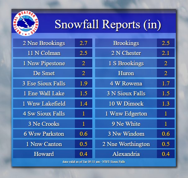
Accumulating snow began across the Black Hills of South Dakota on Friday night before spreading eastward and whitening Sioux Falls, South Dakota, with 1.5 inches on Saturday morning.
Milwaukee is forecast to pick up several inches of wet snow from the storm during Saturday evening.
It is during the late afternoon and at night when Chicago can receive snow and experience a period of slippery travel.
Gusty winds can whip the snow and dramatically reduce visibility for motorists. There can also be a few rumbles of thunder amid the snow during the height of the storm.
The snow event would primarily be from Saturday night to Sunday morning in Michigan.
Meanwhile, Detroit is forecast to pick up a coating to an inch or two of snow during Saturday night as well.
RELATED:
4 things to inspect on your vehicle during spring
Body of renowned climber recovered from avalanche field on forbidding Canadian mountain
These 2 EMTs drove their ambulance into an EF3 tornado and survived -- and they have the video to prove it
4 things to inspect on your vehicle during spring
Body of renowned climber recovered from avalanche field on forbidding Canadian mountain
These 2 EMTs drove their ambulance into an EF3 tornado and survived -- and they have the video to prove it
The potential for snow may not be limited to the North Central states.
There is the potential for not only wet snow, but perhaps a couple of inches of the white stuff over parts of northern Pennsylvania, New York state and some mountains in New England from Saturday night to Sunday evening.
South of the swath of snow, showers and thunderstorms are in store from the middle Mississippi Valley to northern Texas. Some of the storms can be quite heavy and gusty during the afternoon and evening hours with localized severe weather possible.
Download the free AccuWeather app for the latest forecast in your community. Keep checking back for updates on AccuWeather.com and stay tuned to the AccuWeather Network on DirecTV, Frontier and Verizon Fios.


No comments:
Post a Comment