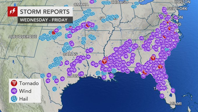
Calmer weather settling in over the southern and eastern United States early this week will continue to assist cleanup efforts in the wake of the three-day severe weather outbreak.
The outbreak left a trail of damage from the southern Plains to the Atlantic coast spanning this past Wednesday to Friday.
The violent storms targeted many of the same areas that were struck with severe weather on April 13-14.
A much quieter stretch of weather is unfolding as home and property owners continue the process of cleaning up debris.
RELATED:
At least 5 dead after 3-day severe weather outbreak slams southern, eastern US
Where has the tornado threat been greatest in the US?
Severe weather, flood risks to ramp back up across south-central US this week
What to do immediately after a tornado strikes your area
At least 5 dead after 3-day severe weather outbreak slams southern, eastern US
Where has the tornado threat been greatest in the US?
Severe weather, flood risks to ramp back up across south-central US this week
What to do immediately after a tornado strikes your area
Mainly dry weather is expected to last into at least Tuesday across portions of the Southeast and lower mid-Atlantic that were hit hard with severe weather, according to AccuWeather Meteorologist Brett Edwards.
After ending Easter Sunday with spotty showers, most of the mid-Atlantic will dry out on Monday.

"Conditions will trend warmer into Tuesday," Edwards said.
Widespread highs in the 80s are expected from Mississippi to southern South Carolina on Monday underneath bright sunshine and low humidity.
The 80-degree-Fahrenheit temperatures will spread through the rest of the Carolinas, much of Virginia and into Washington, D.C., Baltimore and Philadelphia on Tuesday.

Ripped tree branches litter a Learned, Miss., home, following severe weather that hit the small community, Thursday, April 18, 2019. (AP Photo/Rogelio V. Solis)
The dry stretch will allow rivers in the southern Appalachians that took on a surge of water from Friday's heavy storms to recede below flood stage.
Even with no rain forecast, motorists should continue to use caution as some roads may remain blocked by trees, power lines and other debris.
The next opportunity for wet weather may not arrive until later week as a new storm rumbles across the South.

The storm will first return the dangers of flooding and severe weather to the southern Plains later Monday into Wednesday before targeting the lower Mississippi Valley on Thursday.
Showers and thunderstorms will shift to the Southeast on Friday.
Download the free AccuWeather app to keep up to date with the forecast for your area. Keep checking back for updates on AccuWeather.com and stay tuned to the AccuWeather Network on DirecTV, Frontier and Verizon Fios.


No comments:
Post a Comment