Pacific storms will sweep into the northwestern United States on occasion into next week, keeping temperatures from returning to record high levels.
Western Washington basked in warmth that made it feel more like the beginning of summer than the start of spring this week.
Seattle set a new mark for its highest March temperature on record as the mercury soared to 79 degrees Fahrenheit on both Tuesday and Wednesday.
The city also recorded three consecutive days with temperatures above 75, which is the first time this has ever happened in March since records began in 1894.
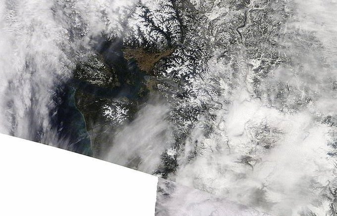
Considering we had snow in the area less than two weeks ago, one might wonder how the current warmth affects snow cover. Here's a composite view from NASA's MODIS satellite looking at the area at the same time over the past 5 days. #wawx

See NWS Seattle's other Tweets
"The recent stretch of dry weather and record warmth has come to an end in the Pacific Northwest," said AccuWeather Meteorologist Ryan Adamson.
The good news for warm-weather fans is that even though the peak warmth has passed, conditions have not plummeted to chilly levels by any means.
Temperatures will remain a few degrees above normal through the weekend, according to Adamson.
In Seattle, highs in the lower to middle 60s are forecast each day through Sunday, when average highs are in the middle 50s.
RELATED:
Stunning satellite photo shows what the vernal equinox looked like from 22,300 miles away
Why weather keeps throwing MLB curveballs and how it impacted 6 memorable games
Poll: Which of these extreme photos best captures this winter's wrath?
Stunning satellite photo shows what the vernal equinox looked like from 22,300 miles away
Why weather keeps throwing MLB curveballs and how it impacted 6 memorable games
Poll: Which of these extreme photos best captures this winter's wrath?
Those out and about enjoying the mild weather will have to dodge rain showers on occasion.
After one round of wet weather moves through to end the week, "another opportunity for light precipitation will arrive on Saturday afternoon," Adamson said.

There is the potential for isolated thunderstorms with small hail to rumble along and just west of the Interstate 5 corridor. If you are outside and hear thunder, head into a building or hard-top vehicle immediately.
The recent spell of dry weather will mean that roadways can be extra slippery at the onset of rain due to oil buildup. Motorists are advised to slow down to lessen the risk of hydroplaning while traveling at highway speeds.
Sunday is shaping up to be the best day of the weekend for outdoor plans before a potentially more potent storm arrives on Monday, according to Adamson.

If this storm contains enough moisture, the combination of a moderate amount of rainfall and snowmelt at the intermediate elevations may cause minor flooding of rivers flowing out of the Cascades.
Northern California will also get hit with a brief burst of rain and mountain snow from the early-week storm.

Cooler air can accompany this storm's push onshore with temperatures falling closer to seasonable levels.
AccuWeather meteorologists will be keeping a close eye on another storm that will be targeting the West Coast, perhaps mainly Northern California, around the middle of next week.
Download the free AccuWeather app to see the exact forecast for your location.


No comments:
Post a Comment