By Renee Duff, AccuWeather meteorologist
May 28, 2018, 11:44:34 PM EDT
Record heat will continue to bake the central United States and fuel severe thunderstorms across the High Plains to close out Memorial Day holiday weekend.
“Temperatures across the north-central Plains to the Midwest will run 16-20 degrees Fahrenheit above normal [through Memorial Day],” AccuWeather Lead Long-Range Meteorologist Paul Pastelok said.
Memorial Day brought another day of record-challenging heat in the cities of Minneapolis; Green Bay, Wisconsin; Des Moines, Iowa; and St. Louis and Kansas City, Missouri.
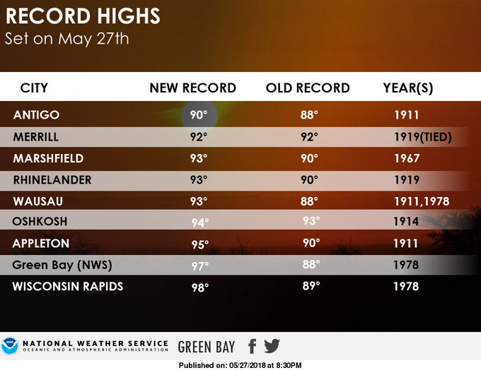
On Sunday, the temperature in Green Bay soared to 97 degrees, which not only smashed their previous record high for the day but also beat out Phoenix's high by 4 degrees.
Even areas farther south that are accustomed to extreme heat will be baking in abnormally high temperatures for this time of year.
People are reminded never to leave pets or children in a vehicle, even if the windows are cracked. Use caution when touching doorknobs, hand railings or other metal objects that have been in the sun.
RELATED:
How to avoid grilling mishaps this Memorial Day weekend
Triple-digit heat to expand across south-central US, challenge records by late week
Reports: Flood risk to continue in wake of Alberto's landfall
How to avoid grilling mishaps this Memorial Day weekend
Triple-digit heat to expand across south-central US, challenge records by late week
Reports: Flood risk to continue in wake of Alberto's landfall
Make sure to walk dogs during the evening hours to avoid burning their paws on hot pavement. This is also the best time to do outdoor projects or exercise.
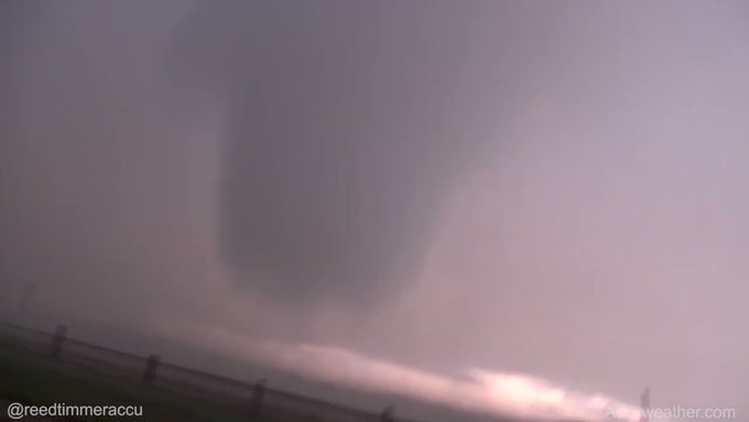
The intense heat fueled severe thunderstorms from Wyoming to Kansas on Sunday. One storm spawned an intense tornado near Cheyenne, Wyoming.
Another round of severe weather is unfolding on Memorial Day.
Into Monday evening, severe storms will again threaten the corridor that was struck on Sunday, as well as expand slightly farther east across the Dakotas, Nebraska and Kansas.
The severe storms are expected to erupt just east of Denver, but the communities of Limon, Colorado; Rapid City, South Dakota; North Platte and Alliance, Nebraska; and Goodland and Dodge City, Kansas; are expected to lie right in the heart of the threat zone.

Damaging winds in excess of 60 mph, hail large enough to inflict damage and injure anyone caught outside and excessive downpours will be the main threats from the storms. However, tornadoes will again be possible.
Several landspout tornadoes touched down in eastern Colorado just north of Interstate 70 on Monday evening. At one point, several landspouts were spinning at the same time right next to each other.
Given that the region was soaked by storms on Sunday, the threat for flash flooding will also be elevated.
Motorists on stretches of interstates 70, 80 and 90 should be prepared to face downpours heavy enough to reduce visibility to near zero. Some roadways may be covered with hail.
People preoccupied with holiday cookouts, parades and memorial services should keep close eye to the sky and be prepared to seek shelter if storms approach.
A new round of severe weather will take aim at the northern and central Plains on Tuesday as heat intensifies to the south.


No comments:
Post a Comment