Tuesday, May 29, 2018

Torrential downpours from Alberto to drench Chicago, midwestern US at midweek

By Alex Sosnowski, AccuWeather senior meteorologist
May 29, 2018, 2:35:23 PM EDT


As Alberto moves northward, downpours, isolated flash flooding and locally severe thunderstorms will affect part of the Midwest, including the Chicago area, at midweek.
Alberto, currently dubbed a subtropical depression by the National Hurricane Center, has both tropical and non-tropical characteristics.
Static Alberto Track 2 pm

Alberto contains moisture similar to a tropical storm but also has pockets of dry air and is much more spread out, which is more typical of large storms that occur during the fall, winter and spring.
Showers and thunderstorms from Alberto will spread from the Tennessee Valley into Tuesday night to the Ohio Valley and Great Lakes from Wednesday to Thursday.
Static Alberto Impact Wednesday
Showers and thunderstorms are forecast to occur outside of the shaded area. However, these downpours will be more spotty in nature and only a result of indirect effects from Alberto.

The air will be noticeably more humid as the storm moves across the region. This high level of moisture in the air will fuel locally torrential downpours.
The storm still contains enough of a circulation to cause a stiff breeze for a time and locally gusty thunderstorms.
Motorists should be prepared for sudden downpours that may flood streets and low-lying portions of highways.
Where thunderstorms gather and strengthen and approach major metro areas, such as Chicago, Milwaukee and Indianapolis, the potential for airline delays will increase significantly.
The greatest impact from Alberto in these major cities, as well as Detroit, Cincinnati and St. Louis, and other towns and rural areas in the region will be from Wednesday to Wednesday night.
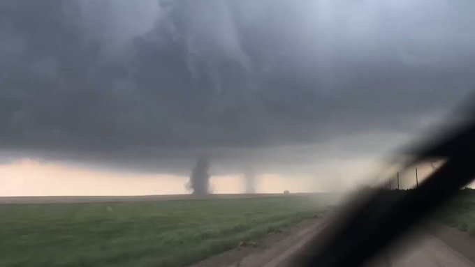
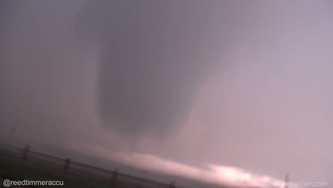
Alberto may spawn severe thunderstorms
One area that may experience locally severe thunderstorms is forecast to extend from southeastern Michigan through much of Ohio to central West Virginia and southwestern Pennsylvania.
Static Wednesday Severe

"While Alberto has not produced any tornadoes through mid-afternoon on Tuesday, there is a chance of a couple of tornadoes being spawned over part of the Midwest on Wednesday afternoon and evening," according to AccuWeather Senior Storm Warning Meteorologist Rich Putnam.
The greatest threats from the storms on Wednesday will be from flash flooding and damaging wind gusts.
Indirect effects from Alberto, by way of tropical downpours, will extend into the northeastern United States as well.
Cooler, less humid air to slowly advance in Alberto's wake
During the latter part of the week, Alberto will travel northeastward across Canada and its direct impact will diminish. However, non-tropical impact from non-tropical weather systems will remain and increase.
Humid air will linger in the wake of Alberto over the Ohio Valley and eastern Great Lakes on Thursday. This humid air may continue to allow showers and thunderstorms to pop up.
Dry and cooler air is forecast to build southward from central Canada and across the Great Lakes and upper Mississippi Valley for a time late this week and this weekend.
Static Saturday NE

Much of the area from the Mississippi River to the Ohio Valley and Great Lakes may be free of rain on Saturday.

2018 French Open: Showers, storms to threaten further delays this week

By Eric Leister, AccuWeather senior meteorologist
May 29, 2018, 1:18:25 PM EDT


As the opening rounds of the French Open continue this week, there will be a risk for further delays and suspension of matches.
Rain forced the suspension of matches on Monday and caused delays on Tuesday.
The threat for daily showers and thunderstorms will continue at Roland Garros through at least Friday.
French Open2 5/29

With all of the courts being uncovered, including the center court, Court Philippe Chatrier, even a few showers could bring about a string of delays. An expansion project, expected to be completed by 2020, will add a roof and more seats to Court Philippe Chatrier.
While all-day washouts are not expected, showers and thunderstorms can quickly pop up anytime throughout the day, causing delays and drenching spectators.
The recent unseasonable warmth will continue into Friday with daily high temperatures expected to range between 21 and 26 Celsius (70 and 79 Fahrenheit). The normal high temperature in Paris in late May is 20.6 C (79 F).
Anyone attending matches over the next several days will want to be prepared with light-colored clothing, sunglasses and sunscreen, while also being ready for sudden rainfall with a poncho or umbrella.
Largely dry weather is expected to return to Roland Garros from Saturday into Monday, reducing the risk for delays but allowing temperatures to climb a few degrees higher. Highs on Sunday and Monday are expected to be around 27 C (80 F).
Another slow-moving storm system is expected to arrive next week, bringing several days of unsettled weather with an elevated risk for thunderstorms.

Risk of downpours, flash flooding to increase in northeastern US by late week

By Alex Sosnowski, AccuWeather senior meteorologist
May 29, 2018, 2:33:06 PM EDT


A surge of tropical air will cause downpours to spread and the risk of flash flooding to increase over the northeastern United States late this week and into this weekend.
The vast majority of locations will not experience a repeat of the tragic and devastating flash flooding that occurred in Ellicott City, Maryland, from this past Sunday. However, there is the likelihood of isolated flash flooding incidents in the upcoming weather pattern.
From late this week through this weekend, a general 1-3 inches of rain is likely with highly localized amounts up to 6 inches possible.
As the pattern evolves, motorists should be prepared for localized torrential downpours that may quickly flood streets and low-lying portions of highways.
Static Thursday Friday Downpours NE

Thunderstorms may gather and strengthen, which may cause airline delays as they converge on the airport hubs.
"The main impact from the downpours will be to deter outdoor activities," according to AccuWeather Senior Meteorologist Brett Anderson.
Rainfall to be indirectly associated with Alberto
While Alberto is forecast to trek northward over the central U.S. and then across interior Canada, more humid air to flow into the Northeast from Wednesday to Saturday.
Alberto formed near Mexico's Yucatan Peninsula late last week and rolled ashore along the upper Gulf Coast on Monday afternoon as a storm containing both tropical and non-tropical characteristics.
Static Alberto Track 2 pm

The counterclockwise circulation around Alberto will draw moisture northward from both the Gulf of Mexico and the Atlantic Ocean.
Timetable of rainfall
The best bet for outdoor plans and travel will into the middle of this week, even though the weather pattern supports spotty showers and thunderstorms, mainly during the afternoon and evening hours.
Static NE Wednesday

Much of central and northern New England is likely to be free of rain through Wednesday night.
"On Thursday, a more liberal spread of showers and thunderstorms are likely across the mid-Atlantic, central Appalachians, the eastern Great Lakes and western New England," Anderson said. "By Friday, showers and thunderstorms may occur at any time in all but the immediate New England coast."
As the weekend progresses, a push of cooler and less humid air is forecast to advance southeastward from Ontario and Quebec.
Static Saturday NE

While this push may eventually mark an end to showers and thunderstorms over part of the Northeast's interior, it may also enhance the rainfall in some areas for a time this weekend.
For portions of the mid-Atlantic and New England coasts, where humid air may linger, Saturday and Sunday could be the wettest days with an area of drenching rain instead of showers and thunderstorms.

2018 Atlantic hurricane season: Is Puerto Rico at risk for another devastating blow?

By Jillian MacMath, AccuWeather staff writer
May 29, 2018, 1:22:32 PM EDT


Following a devastating blow to Puerto Rico during the 2017 Atlantic hurricane season, forecasters are keeping their eyes on the U.S. territory in case of another life-threatening impact this year.
Atlantic hurricane season officially begins on June 1, though the most likely time for the island to experience tropical impacts spans from the last week of August to the first week of September.
In 2017, Hurricane Maria struck within this time frame, resulting in the second-biggest blackout in the history of power on Earth and a huge number of fatalities.
Official figures suggested fewer than 100 people died as a result of the hurricane; however, estimates factoring in indirect deaths climbed to over 1,000 by other agencies in the following months.
A new study published on May 29 by researchers from Harvard University's T.H. Chan School of Public Health puts the death toll estimate even higher. According to the study, as many as 4,645 "excess deaths" may have occurred as a result of the storm between Sept. 20 and Dec. 31, 2017. 
Trump Fema
President Donald Trump walks with FEMA administrator Brock Long, second from right, and Lt. Gen. Jeff Buchanan, right as he tours an area affected by Hurricane Maria in Guaynabo, Puerto Rico, Tuesday, Oct. 3, 2017. (AP Photo/Evan Vucci)

While Puerto Rico continues to pick up the pieces and rebuild its outdated power grid, many fear another impact could have catastrophic consequences.
While it is impossible to say for certain what will transpire this season, forecasters say a direct hit is unlikely.
AccuWeather Atlantic Hurricane Expert Dan Kottlowski said, “Statistically it would be unusual for Puerto Rico or the Virgin Islands to have direct impacts from a tropical storm or hurricane in back-to-back years.“
The last time this happened was in 1931 and 1932.
Before Maria, the last direct hit to Puerto Rico was back in 2011, when an intensifying Hurricane Irene crossed the northeastern part of the Island inflicting heavy rainfall and hurricane-force wind gusts.
This year, the more likely scenario would be for Puerto Rico to experience impacts from a tropical storm or hurricane, rather than sustain a direct hit.
According to data, this occurs every three to four years.
AccuWeather’s official 2018 hurricane forecast calls for 12-15 storms in the Atlantic basin overall, six to eight of which are forecast to be hurricanes and three to five of which may be major hurricanes.
“This hasn’t changed since our official release in early April,” Kottlowski said. 
2018 atlantic hurricane season forecast

According to the outlook, sea surface temperatures are cooler than normal across the main developmental region where around 85 percent of all tropical storms and hurricanes originate.
He added, “If these cooler sea surface temperatures last into and through the summer, tropical development would favor the lower number values.”
Last year, the area was cooler than normal initially, before warming to above normal by Sept. 1.
Kottlowski said, “Preseason and early-season sea surface temperatures often don’t stay cool unless trade winds remain higher than normal,” as strong trade winds tend to result in cooler sea surface temperatures.
“Last year, the trade winds died down and ocean waters warmed up,” he said.
maria puerto rico
(Photo/NASA Earth Observatory Joshua Stevens)

Current computer models, which forecasters use to predict these changes, are mixed on the strength of the trades for August, September and October.
“We hope to see some trend by early July which should help give us more confidence,” Kottlowski said.
Despite this uncertainty, a direct hit remains statistically unlikely.
Kottlowski said, “This far out it is impossible to know how future tropical storms and hurricanes are going to track.”
“We may see some signal by early July, but it would be rare for the Virgin Islands and Puerto Rico to experience another high impact storm this year.”

Central US to face another round of severe weather into Tuesday evening

By Renee Duff, AccuWeather meteorologist
May 29, 2018, 8:53:55 PM EDT


The severe thunderstorms that hammered the High Plains over the holiday weekend will shift eastward across the central United States into Tuesday night.
One of the stronger thunderstorms on Tuesday afternoon produced a tornado near Ensign, Kansas, located southeast of Dodge City. 
Ensign, KS tornado
A tornado near Ensign, Kansas, on Tuesday May 29, 2018. (Photo/Garrison Hendricks)

Over one dozen tornadoes were spawned over Wyoming, Colorado and Kansas, from Sunday through Monday, with high winds and large hail reported with storms from South Dakota to the Texas Panhandle.

Heavy storms late on Memorial Day unleashed over 7 inches of rain across western Kansas, which prompted flash flood warnings and triggered street flooding.
The slow-moving system that triggered the multiple days of violent weather will sweep into the northern and central Plains.
"Tuesday evening may be one of the most extensive evenings for severe weather so far this season," according to AccuWeather Senior Meteorologist Alex Sosnowski..
This will result in a slight eastward shift in the area at risk for severe weather, which will span from Minnesota to Oklahoma through Tuesday evening.
The storms will feed off continued record-challenging heat and high humidity.
All modes of severe weather will be possible in thunderstorm activity, including large hail and a couple of tornadoes, according to AccuWeather Lead Long-Range Meteorologist Paul Pastelok.
Damaging winds and flash flooding will also be possible.
As evidenced on Monday, flash flooding can occur despite an ongoing drought over the central Plains.
Static Tuesday Evening Severe 3 pm

Residents from Fargo, North Dakota, to Sioux Falls, South Dakota; St. Cloud and Minneapolis, Minnesota; Sioux City, Iowa; Lincoln and Omaha, Nebraska; Salina, Wichita and Dodge City, Kansas; and Oklahoma City, should monitor the weather throughout the day and be prepared to seek sturdier shelter if necessary.
People may want to consider moving their vehicle under a carport or in a garage to prevent costly hail damage. Cellphones should be kept fully charged in case the power goes out.
The storms will cross stretches of interstates 29, 35, 70, 80, 90 and 94, causing times of poor visibility and slow travel.
Secondary roads may be closed due to flooding.
While storms over the central U.S. will tend to be more heavy and gusty as opposed to severe at midweek, Pastelok anticipates that more organized severe weather will return late in the week.
"Severe weather will start Thursday in the northern Rockies and northern Plains and move eastward into the Upper Midwest by Saturday," he said.

Record heat to fuel severe storms across central US to end Memorial Day

By Renee Duff, AccuWeather meteorologist
May 28, 2018, 11:44:34 PM EDT


Record heat will continue to bake the central United States and fuel severe thunderstorms across the High Plains to close out Memorial Day holiday weekend.
“Temperatures across the north-central Plains to the Midwest will run 16-20 degrees Fahrenheit above normal [through Memorial Day],” AccuWeather Lead Long-Range Meteorologist Paul Pastelok said.
Memorial Day brought another day of record-challenging heat in the cities of Minneapolis; Green Bay, Wisconsin; Des Moines, Iowa; and St. Louis and Kansas City, Missouri.
On Sunday, the temperature in Green Bay soared to 97 degrees, which not only smashed their previous record high for the day but also beat out Phoenix's high by 4 degrees.

Even areas farther south that are accustomed to extreme heat will be baking in abnormally high temperatures for this time of year.
People are reminded never to leave pets or children in a vehicle, even if the windows are cracked. Use caution when touching doorknobs, hand railings or other metal objects that have been in the sun.
Make sure to walk dogs during the evening hours to avoid burning their paws on hot pavement. This is also the best time to do outdoor projects or exercise.
The intense heat fueled severe thunderstorms from Wyoming to Kansas on Sunday. One storm spawned an intense tornado near Cheyenne, Wyoming.

Another round of severe weather is unfolding on Memorial Day.
Into Monday evening, severe storms will again threaten the corridor that was struck on Sunday, as well as expand slightly farther east across the Dakotas, Nebraska and Kansas.
The severe storms are expected to erupt just east of Denver, but the communities of Limon, Colorado; Rapid City, South Dakota; North Platte and Alliance, Nebraska; and Goodland and Dodge City, Kansas; are expected to lie right in the heart of the threat zone.
Monday severe May 28

Damaging winds in excess of 60 mph, hail large enough to inflict damage and injure anyone caught outside and excessive downpours will be the main threats from the storms. However, tornadoes will again be possible.
Several landspout tornadoes touched down in eastern Colorado just north of Interstate 70 on Monday evening. At one point, several landspouts were spinning at the same time right next to each other. 

Given that the region was soaked by storms on Sunday, the threat for flash flooding will also be elevated.
Motorists on stretches of interstates 70, 80 and 90 should be prepared to face downpours heavy enough to reduce visibility to near zero. Some roadways may be covered with hail.
People preoccupied with holiday cookouts, parades and memorial services should keep close eye to the sky and be prepared to seek shelter if storms approach.
A new round of severe weather will take aim at the northern and central Plains on Tuesday as heat intensifies to the south.

Man missing at sea for nearly 2 weeks found alive in life raft off Washington coast

  One of two men missing at sea for nearly two weeks was found alive on Thursday by a Canadian fishing boat in a life raft in Canadian water...