Tuesday, March 31, 2020

Severe Thunderstorms Spawn Tornadoes in the Deep South Tuesday

weather.com meteorologists
Published: March 31, 2020


Strong to severe thunderstorms, including tornadoes, hammered parts of the Southeast Tuesday as a low-pressure system tracked across the region.
An apparent tornado in Madison, Florida, late Tuesday afternoon took down trees along Interstate 10, blocking portions of the highway.
Around midday Tuesday, a tornado damaged at least a dozen homes just south of Eufaula, Alabama, along the border with southwestern Georgia, according to the city's mayor.
The same line of severe thunderstorms earlier spawned a tornado near the Troy Municipal Airport in Alabama Tuesday morning. Numerous trees were blown down in central Alabama near Tennant, where a barn was destroyed.
And earlier Tuesday morning, an apparent tornado destroyed at least one mobile home in George County, Mississippi. A waterspout was later sighted over Mobile Bay.
The Weather Company’s primary journalistic mission is to report on breaking weather news, the environment and the importance of science to our lives. This story does not necessarily represent the position of our parent company, IBM.

Are Freezing Temperatures Over? When the Last Freeze of the Season Typically Occurs

Linda Lam and Brian Donegan
Published: March 31, 2020
Based on 1981-2010 averages.
Although many may be looking forward to prolonged warmth when spring arrives, the average date of the last freeze varies greatly across the United States.
The last freeze of the season is used not only by gardeners, but also by anyone looking to finally pack away their winter coat for the season.
The map above illustrates when the last freeze of the season typically occurs, based on averages from 1981-2010 . Keep in mind that the last freeze can vary greatly from year to year depending on the country's weather pattern during the spring months.
Much of the South usually has its last freeze of the season before the end of March, while the higher elevations of the West may not see the last 32-degree temperature until late May or even June.
This year, most of the East and South have had well above-average temperatures in March, and many locations will likely end up with a top-five-warmest March, according to data from the Southeast Regional Climate Center. This trend of warmer temperatures in the South and East with cooler-than-average temperatures in the North and West will likely continue into April. This suggests that many areas of the Lower 48 may not have a late last freeze, but a spring cold blast can occur even in an overall warm spring.
Let's dig deeper into when specific regions and cities can expect the season's average final freeze.

Before March 10

Cities along the Gulf Coast and in the Deep South have their average last freeze before March 10. This can occur much earlier or much later depending on the weather conditions each year.
Since 1950, Miami has only recorded five winter seasons with a freeze: 1976-77, 1979-80, 1980-81, 1984-85 and 1989-90.
The map at the top of this article also shows an area in the Desert Southwest and Southern California that has its average last freeze before March 10. This includes Los Angeles and San Diego, but these cities don't typically have freezing temperatures.
Since 1950, San Diego has only dropped to 32 degrees or colder one time (Jan. 13, 1963) at Lindbergh Field. Los Angeles International Airport dropped to the freezing mark or colder the same date as San Diego and also on Dec. 21, 1968.

March 10-30

A large part of the South, along with parts of the Interstate 95 corridor, Desert Southwest and West Coast, typically experience their last freeze between March 10 and March 30.
Chilly spring conditions have pushed the last freeze of the season to as late as April or even early May. Atlanta has experienced its last freeze of the season as late as April. However, freezing temperatures in late April last occured in 1986.

March 30-April 10

A broad area from southern New Mexico to the Northeast urban heat islands typically experiences its last freeze of the season in late March or early April.
It is interesting to note Boston's latest last freeze is earlier than Raleigh, North Carolina's, by a week and a half, likely due to Boston's proximity to the relatively warmer Atlantic Ocean.

April 10-30

Many cities from the Plains and Midwest to the East Coast have their average last freeze in mid to late April in an average year.
If you live in any of these cities, despite your average final freeze in mid- to late April, it may be best to wait until closer to Memorial Day to plant your garden. In Chicago, the last freeze occurred as late as May 25 in 1992, which was Memorial Day that year.

April 30-May 20

Average last freeze dates in early to mid-May are basically confined to the nation's northern tier and Mountain West.
Despite these cities having their last freeze in early to mid-May in an average year, sometimes it doesn't occur until around or after the summer solstice (June 20 this year), such as in Fargo, North Dakota; Concord, New Hampshire; and Reno, Nevada.

After May 20

Any freezes after May 20 typically occur in areas near the Canadian border or in the highest elevations of the Rocky Mountains.
The Weather Company’s primary journalistic mission is to report on breaking weather news, the environment and the importance of science to our lives. This story does not necessarily represent the position of our parent company, IBM.

The Weather Company’s primary journalistic mission is to report on breaking weather news, the environment and the importance of science to our lives. This story does not necessarily represent the position of our parent company, IBM.

April Weather Brings Everything: Severe Storms, Warmer Temperatures, Snow and Even Tropical Storms

Linda Lam
Published: March 31, 2020


April can bring a variety of weather conditions as winter tries to hang on and temperatures warm up. That collision can result in severe storms and flooding. Tropical storms have even formed in the Atlantic in April.
For those hoping not to experience a repeat of a cold April 2018, the news is good: Persistent cold and snow are not expected this year.
Here's a closer look at what to expect this month.

Warmer Temperatures Finally Emerge

From the beginning to the end of the month, many locations experience a noticeable jump in average temperatures. New York City sees its average high rise from 56 degrees on April 1 to 66 degrees on April 30. The average high in Minneapolis increases from 50 degrees to start the month to 65 degrees to close out April. Average lows here also rise from the lower 30s to the mid-40s during April.
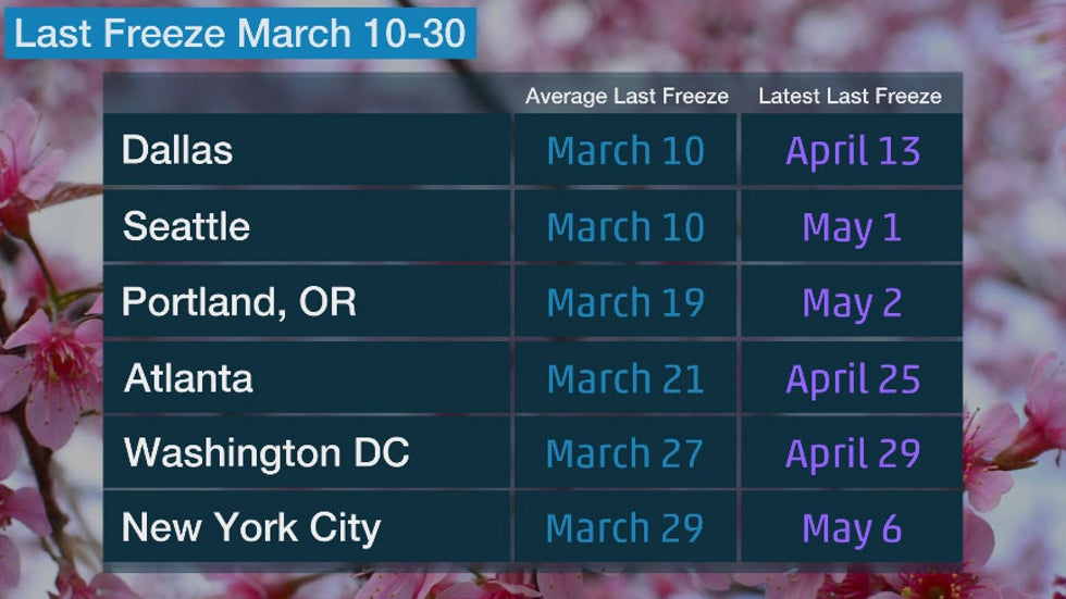
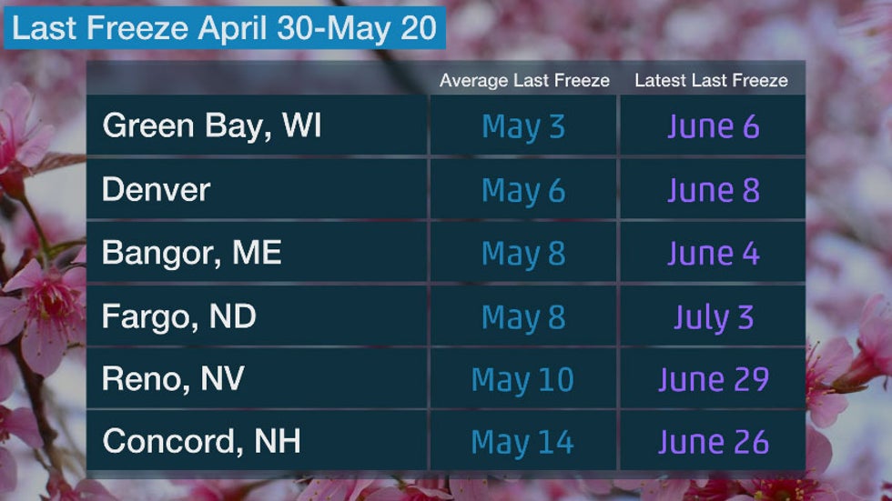
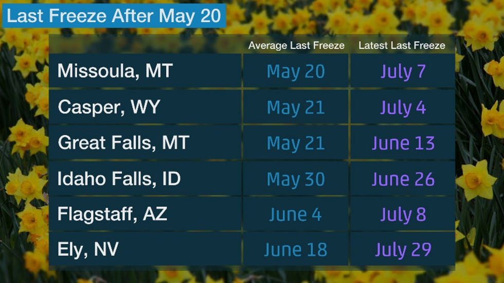
By the end of April, the South, mid-Atlantic, Ohio Valley and central Plains have generally experienced their last freeze of the season. Much of the Northeast, upper Midwest and Intermountain West wait until mid-May to see the last freeze.
But not every April is dominated by spring warmth. April 2018 was stubbornly cold east of the Rockies, the 13th-coldest April on record in the contiguous U.S. Iowa and Wisconsin both shivered through their coldest April on record.
This April, most of the country is expected to see near- or above-average temperatures.
April 2020 Temperature Outlook

Tornado Risk Increases

As temperatures rise, moisture increases and thunderstorms become more common. The risk of tornadoes also increases as the ingredients for severe weather are more often in place.
Tornado outbreaks often occur when a low-pressure system accompanied by a strong, southward dip in the jet stream punches into the Plains, Midwest or South. In addition, warm and humid air flows northward out of the Gulf of Mexico.
Typical tornado risk in April.
In April, the tornado threat is greatest from southeastern Kansas, Oklahoma and northern Texas eastward into parts of Alabama.
April is typically the third-busiest month for tornadoes, with May and June coming in first and second, respectively. April 2011 set a record for most tornadoes in any month with 758, due in large part to the April 26-28 outbreak.

More Rain Can Lead to Flooding

April can be an active month with low-pressure systems tracking across the U.S.
These can bring rounds of rain, which, when combined with snowmelt due to the warming temperatures, can result in river flooding.
NOAA noted in its spring flood outlook that more widespread flooding is expected in the central and southern U.S.
A separate April precipitation outlook from NOAA indicates that the chance for above-average precipitation is greatest in parts of the Southeast and central U.S.
April 2020 precipitation outlook.

It Can Still Snow

Although temperatures increase in April, snow is still possible, especially in the higher elevations of the West.
There are a few spots where April is the snowiest month. These include Breckenridge, Colorado; Casper, Wyoming; and Mount Rushmore, South Dakota. Denver can also experience some of its heavier snowfalls in April.
The average snowiest month in areas that typically pick up over 3 inches of snow each year, based on 1981-2010 average snowfall data.
In 2018, the record-breaking cold in April helped to set new snow records. In mid-April, Winter Storm Xanto brought 15.8 inches to Minneapolis/St. Paul, making it the heaviest April snowstorm on record there. Xanto was also the heaviest April snowstorm in Green Bay, Wisconsin, where 24.2 inches accumulated and blizzard conditions were observed.

Tropical Storms Can Develop in the Atlantic

Although the Atlantic hurricane season officially begins on June 1, tropical cyclones sometimes develop before then.
Two tropical storms have developed in the Atlantic in April. The first was Ana in 2003, and most recently, Arlene in 2017. A subtropical storm also developed in April 1992.
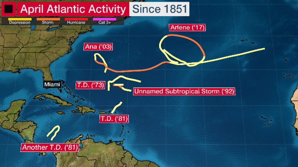
Tracks of April Atlantic Basin tropical cyclones in records dating to 1851.
Conditions are often not favorable for tropical development in April, but sometimes an area with the right environmental conditions emerges and can result in the formation of a tropical cyclone.
Pre-season tropical systems are frequently lopsided and fairly shallow in height.
There are no Atlantic hurricanes on record during April.
The Weather Company’s primary journalistic mission is to report on breaking weather news, the environment and the importance of science to our lives. This story does not necessarily represent the position of our parent company, IBM.


Three Tornadoes From Saturday Were Rated EFU; Here's What That Means


Chris Dolce
Published: March 31, 2020


The red icons show the approximate locations of Saturday's three EFU tornadoes.
Three tornadoes from Saturday's severe weather outbreak in the Midwest were not assigned a rating by the National Weather Service (NWS) because they briefly touched down in rural locations and there was no evidence of damage.
Tornadoes are typically rated from EF0 (light damage) to EF5 (catastrophic damage) on the Enhanced Fujita Scale based on the damage that they cause, not by their appearance or any other real-time metric. But when a tornado strikes a mostly rural area with few structures or trees, the damage may be so sparse it can be difficult for the NWS to estimate the strength of the winds.
When there is no tornado damage but there is evidence a tornado existed, the NWS can give an EFU rating for "unknown" to be used in official records. Two tornadoes in Iowa and one in Illinois from Saturday matched the criteria to be rated EFU.
The tornado in Illinois was located southeast of the Quad Cities and was confirmed based on storm spotter and photo evidence. It was on the ground for about one minute and 1.1 mile.
Iowa's two EFU tornadoes were located between Des Moines and Waterloo. They both lasted a minute and tracked for 0.8 miles and 1 mile, respectively.
There were nearly 200 tornadoes rated EFU in 2019, according to NOAA's Storm Events Database. Many of them were in Plains or Midwest states where there are fewer structures and trees for tornadoes to hit and cause damage that can be rated by an NWS survey team.
The Weather Company’s primary journalistic mission is to report on breaking weather news, the environment and the importance of science to our lives. This story does not necessarily represent the position of our parent company, IBM.

Damage Reported in Northeastern Arkansas as EF3 Tornado Strikes Jonesboro; Flash Flooding Swamps Cleveland


Sean Breslin
Published: March 30, 2020


A severe weather outbreak hit the mid-South and Midwest on Saturday as at least two tornadoes struck northeastern Arkansas.
A large tornado was captured on a highway camera moving into the east side of Jonesboro, Arkansas, during a live broadcast on The Weather Channel at about 5 p.m. CDT Saturday evening. The footage showed debris being lofted into the air, and minutes later, KAIT-TV reported search and rescue operations were underway and vehicles were overturned in the area of the Mall at Turtle Creek.
Most stores at the mall were closed because of the coronavirus pandemic, according to the Associated Press.
The National Weather Service assigned an EF3 rating to the Jonesboro tornado, noting the estimated maximum winds were 140 mph. Hangars were damaged at Jonesboro Municipal Airport, located just northeast of the mall, the NWS said.
A second tornado was also confirmed by the NWS to the northeast of Jonesboro in southeastern Greene County, Arkansas, and was rated EF1.
Twenty-two people were injured by the tornado, but there were no deaths, the Associated Press reported.
After surveying the damage, Jonesboro Mayor Harold Perrin issued a citywide curfew starting at 7 p.m. CDT Saturday, according to KAIT-TV.
Before the supercell reached Jonesboro, a confirmed tornado struck near the town of Amagon, some 30 miles to the southwest.
The storm system that spawned Saturday's severe weather also caused flash flooding in the Cleveland metro area early Sunday morning.
The flooding prompted water rescues and evacuations in several parts of Cuyahoga County, according to a flash flood warning from the NWS. A portion of eastbound Interstate 90 in northeastern Cuyahoga County had to be closed because of the flooding.
The Weather Company’s primary journalistic mission is to report on breaking weather news, the environment and the importance of science to our lives. This story does not necessarily represent the position of our parent company, IBM.

Man missing at sea for nearly 2 weeks found alive in life raft off Washington coast

  One of two men missing at sea for nearly two weeks was found alive on Thursday by a Canadian fishing boat in a life raft in Canadian water...