NORTHERN WESTCHESTER:
...HEAT ADVISORY IN EFFECT FROM NOON TO 9 PM EDT SATURDAY...
The National Weather Service in Upton has issued a Heat Advisory,
which is in effect from noon to 9 PM EDT Saturday.
* HEAT INDEX VALUES...In the upper 90s. Heat index values will be
at least a few degrees higher on Sunday.
* TIMING...Highest heat indices in the mid to late afternoon.
* IMPACTS...Extreme heat can cause illness and death among at-
risk population who cannot stay cool. The heat and humidity
may cause heat stress during outdoor exertion or extended
exposure.
PRECAUTIONARY/PREPAREDNESS ACTIONS...
A Heat Advisory is issued when the combination of heat and
humidity is expected to make it feel like it is 95 to 99 degrees
for two or more consecutive days, or 100 to 104 degrees for any
length of time.
To reduce risk during outdoor work, the Occupational Safety and
Health Administration recommends scheduling frequent rest breaks
in shaded or air conditioned environments. Anyone overcome by
heat should be moved to a cool and shaded location. Heat stroke
is an emergency! In cases of heat stroke call 9 1 1.
&&
===================
SOUTHERN WESTCHESTER:
...HEAT ADVISORY IN EFFECT FROM NOON TO 9 PM EDT SATURDAY...
The National Weather Service in Upton has issued a Heat Advisory,
which is in effect from noon to 9 PM EDT Saturday.
* HEAT INDEX VALUES...In the upper 90s. Heat index values will be
at least a few degrees higher on Sunday.
* TIMING...Highest heat indices in the mid to late afternoon.
* IMPACTS...Extreme heat can cause illness and death among at-
risk population who cannot stay cool. The heat and humidity
may cause heat stress during outdoor exertion or extended
exposure.
PRECAUTIONARY/PREPAREDNESS ACTIONS...
A Heat Advisory is issued when the combination of heat and
humidity is expected to make it feel like it is 95 to 99 degrees
for two or more consecutive days, or 100 to 104 degrees for any
length of time.
To reduce risk during outdoor work, the Occupational Safety and
Health Administration recommends scheduling frequent rest breaks
in shaded or air conditioned environments. Anyone overcome by
heat should be moved to a cool and shaded location. Heat stroke
is an emergency! In cases of heat stroke call 9 1 1.
Friday, June 29, 2018
Thursday, June 28, 2018
New York City metro-area forecast for June 28-July 17,2018
Here's the 20-day weather forecast for the New York City metro-area for the period of June 28-July 17 2018 from accuweather.com
Tonight,June 28-29: Remaining partly cloudy,warm and muggy with a low temperature dropping to the upper 60's to lower 70's,overnight.As of 11PM,EDT,it's 74 degrees with some clouds and 90% humidity,making it feel like it's 80 degrees,in White Plains,NY and it's also 74 degrees and clear, with 93% humidity,making it feel like it's 84 degrees,in New York City.
Tomorrow,June 29: Becoming sunny to partly cloudy and hot with a near record high temperature of 90-95 degrees.
Tomorrow night,June 29-30: Remaining partly cloudy,warm and muggy,with a low temperature dropping to the upper 60's to lower 70's,once again,overnight.
Saturday,June 30: June of 2018 ends turning mostly sunny and very hot with a record high temperature in the middle and upper 90's,the very light,sultry,southwesterly winds and high humidity levels making it feel brutally hot,like it's in the upper 90's to lower 100's,at times.Remaining clear, very warm and sticky with a low temperature dropping to the middle and upper 70's,overnight.
Sunday,July 1: July of 2018 begins turning brutally hot with blazing,sizzling,hazy sunshine and a record high temperature in the upper 90's to lower 100's,the very light,southwesterly winds and high humidity levels making it feel dangerously hot,like it's 110-115 degrees,at times.Remaining clear very warm and steamy,with a low temperature dropping to the middle and upper 70's,once again, overnight.
Monday,July 2: Remaining very hot and steamy with hazy,sizzling sunshine and a near record high temperature in the lower and middle 90's,the light,sultry,southwesterly winds and high humidity levels making it feel quite hot,like it's 100-105 degrees,at times.Remaining clear to partly cloudy, warm and sticky with a low temperature dropping to the lower and middle 70's,overnight.
Tuesday,July 3: Becoming partly sunny,but remaining very hot as the first heatwave of 2018 continues with a high temperature in the lower and middle 90's,once again,the light,steamy, southeasterly winds and high humidity levels making it feel brutally hot,like it's in the lower and middle 100's,at times.Remaining partly cloudy,very warm and sticky,with a chance for late-night thunderstorms,which could be strong to severe,and a low temperature dropping to 70-75 degrees, overnight.
Wednesday,July 4: Independence Day (the Fourth of July),2018 will be remaining very hot and sticky with times of clouds and sun and a chance for a couple of morning thunderstorms possible and a high temperature,for the third straight day,in the lower and middle 90's,the light,steamy,southerly winds and high humidity levels making it feel very hot,like it's 100-105 degrees,at times.Remaining partly cloudy,very warm and sticky,with a low temperature dropping to the middle 70's,overnight.
Thursday,July 5: Becoming partly sunny,but remaining hot with a high temperature of 90-95 degrees.Remaining partly cloudy and warm with a low temperature dropping to the lower and middle 70's,overnight.
Friday,July 6: Becoming mostly cloudy and less humid,but remaining hot,with a high temperature of 90-95 degrees,once again,the very light,southwesterly winds and high humidity levels making it feel much hotter,like it's 100-105 degrees,at times.Becoming partly cloudy,but remaining warm and humid with a low temperature dropping to 70-75 degrees,overnight.
Saturday,July 7: Remaining partly sunny,hot and humid with a chance for a thunderstorm possible and a high temperature,for the third straight day,of 90-95 degrees,the very light,sultry,northwesterly winds and high humidity levels making it feel quite hot,like it's 100-105 degrees,at times.Remaining partly cloudy,warm and humid,with a low temperature dropping to the upper 60's to lower 70's, overnight.
Sunday,July 8: Remaining hot and humid with increasing cloudiness and a high temperature in the upper 80's to lower 90's,the very light,nearly calm,easterly winds and high humidity levels making it feel much hotter,like it's in the upper 90's to lower 100's,at times.Becoming partly cloudy and not as warm,but remaining humid with a low temperature dropping to 65-70 degrees,overnight.
Monday,July 9: Remaining partly sunny and hot with a high temperature of around 90 degrees,the light,sultry,southwesterly winds and high humidity levels making it feel even hotter,like it's in the middle 90's,at times.Remaining warm and humid with increasing cloudiness and a low temperature dropping to around 70 degrees,overnight.
Tuesday,July 10: Not as warm,with mostly cloudy skies and a chance for a shower or thunderstorm possible and a high temperature in the middle 80's,officially ending the first prolonged heatwave of 2018.Remaining mostly cloudy and warm with a low temperature dropping to the upper 60's to lower 70's,overnight.
Wednesday,July 11: Becoming mainly cloudy and seasonably warm for early July and early summer, with a high temperature of 80-85 degrees.Remaining mainly cloudy and seasonably warm with a low temperature dropping to the middle 60's,overnight.
Thursday,July 12: Turning hot,once again,with a mix of sunshine and some clouds and a high temperature in the upper 80's to lower 90's,the very light,sultry,southeasterly winds and high humidity levels making it feel very hot,like it's in the upper 90's to lower 100's,at times.Remaining very warm and humid with considerable cloudiness and a chance for some late-night thunderstorms,which could be strong to severe and a low temperature dropping to the upper 60's to lower 70's,overnight.
Friday,July 13: Remaining very warm and humid with times of clouds and sun and a chance for a scattered afternoon shower or thunderstorm possible and a high temperature in the middle and upper 80's,the very light,sultry,southwesterly winds and high humidity levels making it feel very hot,like it's in the middle 90's,at times.Becoming mainly clear and warm with a low temperature dropping to 65-70 degrees,overnight.
Saturday,July 14: Remaining partly sunny,very warm and sticky with a scattered shower or thunderstorm possible and a high temperature in the middle 80's.Becoming clear,but remaining seasonably warm for mid-July,with a low temperature dropping to the middle 60's,overnight.
Sunday,July 15: Remaining partly sunny and very warm with a high temperature in the middle 80's,once again.Remaining partly cloudy and seasonably warm for mid-July,with a low temperature dropping to the middle 60's,once again,overnight.
Monday,July 16: Remaining seasonably warm for mid-July,with a mix of sun and clouds and a high temperature,for the third straight day,in the middle 80's.Remaining partly cloudy and seasonably warm with a low temperature dropping to the lower and middle 60's,overnight.
Tuesday,July 17: Remaining partly sunny and seasonably very warm with a high temperature,for the fourth straight day,in the middle 80's.Becoming mainly clear and seasonably warm for mid-July and early summer,with a low temperature dropping to the middle 60's,overnight.
Tonight,June 28-29: Remaining partly cloudy,warm and muggy with a low temperature dropping to the upper 60's to lower 70's,overnight.As of 11PM,EDT,it's 74 degrees with some clouds and 90% humidity,making it feel like it's 80 degrees,in White Plains,NY and it's also 74 degrees and clear, with 93% humidity,making it feel like it's 84 degrees,in New York City.
Tomorrow,June 29: Becoming sunny to partly cloudy and hot with a near record high temperature of 90-95 degrees.
Tomorrow night,June 29-30: Remaining partly cloudy,warm and muggy,with a low temperature dropping to the upper 60's to lower 70's,once again,overnight.
Saturday,June 30: June of 2018 ends turning mostly sunny and very hot with a record high temperature in the middle and upper 90's,the very light,sultry,southwesterly winds and high humidity levels making it feel brutally hot,like it's in the upper 90's to lower 100's,at times.Remaining clear, very warm and sticky with a low temperature dropping to the middle and upper 70's,overnight.
Sunday,July 1: July of 2018 begins turning brutally hot with blazing,sizzling,hazy sunshine and a record high temperature in the upper 90's to lower 100's,the very light,southwesterly winds and high humidity levels making it feel dangerously hot,like it's 110-115 degrees,at times.Remaining clear very warm and steamy,with a low temperature dropping to the middle and upper 70's,once again, overnight.
Monday,July 2: Remaining very hot and steamy with hazy,sizzling sunshine and a near record high temperature in the lower and middle 90's,the light,sultry,southwesterly winds and high humidity levels making it feel quite hot,like it's 100-105 degrees,at times.Remaining clear to partly cloudy, warm and sticky with a low temperature dropping to the lower and middle 70's,overnight.
Tuesday,July 3: Becoming partly sunny,but remaining very hot as the first heatwave of 2018 continues with a high temperature in the lower and middle 90's,once again,the light,steamy, southeasterly winds and high humidity levels making it feel brutally hot,like it's in the lower and middle 100's,at times.Remaining partly cloudy,very warm and sticky,with a chance for late-night thunderstorms,which could be strong to severe,and a low temperature dropping to 70-75 degrees, overnight.
Wednesday,July 4: Independence Day (the Fourth of July),2018 will be remaining very hot and sticky with times of clouds and sun and a chance for a couple of morning thunderstorms possible and a high temperature,for the third straight day,in the lower and middle 90's,the light,steamy,southerly winds and high humidity levels making it feel very hot,like it's 100-105 degrees,at times.Remaining partly cloudy,very warm and sticky,with a low temperature dropping to the middle 70's,overnight.
Thursday,July 5: Becoming partly sunny,but remaining hot with a high temperature of 90-95 degrees.Remaining partly cloudy and warm with a low temperature dropping to the lower and middle 70's,overnight.
Friday,July 6: Becoming mostly cloudy and less humid,but remaining hot,with a high temperature of 90-95 degrees,once again,the very light,southwesterly winds and high humidity levels making it feel much hotter,like it's 100-105 degrees,at times.Becoming partly cloudy,but remaining warm and humid with a low temperature dropping to 70-75 degrees,overnight.
Saturday,July 7: Remaining partly sunny,hot and humid with a chance for a thunderstorm possible and a high temperature,for the third straight day,of 90-95 degrees,the very light,sultry,northwesterly winds and high humidity levels making it feel quite hot,like it's 100-105 degrees,at times.Remaining partly cloudy,warm and humid,with a low temperature dropping to the upper 60's to lower 70's, overnight.
Sunday,July 8: Remaining hot and humid with increasing cloudiness and a high temperature in the upper 80's to lower 90's,the very light,nearly calm,easterly winds and high humidity levels making it feel much hotter,like it's in the upper 90's to lower 100's,at times.Becoming partly cloudy and not as warm,but remaining humid with a low temperature dropping to 65-70 degrees,overnight.
Monday,July 9: Remaining partly sunny and hot with a high temperature of around 90 degrees,the light,sultry,southwesterly winds and high humidity levels making it feel even hotter,like it's in the middle 90's,at times.Remaining warm and humid with increasing cloudiness and a low temperature dropping to around 70 degrees,overnight.
Tuesday,July 10: Not as warm,with mostly cloudy skies and a chance for a shower or thunderstorm possible and a high temperature in the middle 80's,officially ending the first prolonged heatwave of 2018.Remaining mostly cloudy and warm with a low temperature dropping to the upper 60's to lower 70's,overnight.
Wednesday,July 11: Becoming mainly cloudy and seasonably warm for early July and early summer, with a high temperature of 80-85 degrees.Remaining mainly cloudy and seasonably warm with a low temperature dropping to the middle 60's,overnight.
Thursday,July 12: Turning hot,once again,with a mix of sunshine and some clouds and a high temperature in the upper 80's to lower 90's,the very light,sultry,southeasterly winds and high humidity levels making it feel very hot,like it's in the upper 90's to lower 100's,at times.Remaining very warm and humid with considerable cloudiness and a chance for some late-night thunderstorms,which could be strong to severe and a low temperature dropping to the upper 60's to lower 70's,overnight.
Friday,July 13: Remaining very warm and humid with times of clouds and sun and a chance for a scattered afternoon shower or thunderstorm possible and a high temperature in the middle and upper 80's,the very light,sultry,southwesterly winds and high humidity levels making it feel very hot,like it's in the middle 90's,at times.Becoming mainly clear and warm with a low temperature dropping to 65-70 degrees,overnight.
Saturday,July 14: Remaining partly sunny,very warm and sticky with a scattered shower or thunderstorm possible and a high temperature in the middle 80's.Becoming clear,but remaining seasonably warm for mid-July,with a low temperature dropping to the middle 60's,overnight.
Sunday,July 15: Remaining partly sunny and very warm with a high temperature in the middle 80's,once again.Remaining partly cloudy and seasonably warm for mid-July,with a low temperature dropping to the middle 60's,once again,overnight.
Monday,July 16: Remaining seasonably warm for mid-July,with a mix of sun and clouds and a high temperature,for the third straight day,in the middle 80's.Remaining partly cloudy and seasonably warm with a low temperature dropping to the lower and middle 60's,overnight.
Tuesday,July 17: Remaining partly sunny and seasonably very warm with a high temperature,for the fourth straight day,in the middle 80's.Becoming mainly clear and seasonably warm for mid-July and early summer,with a low temperature dropping to the middle 60's,overnight.
Thursday becomes UK hottest day of the year; Heat wave set to last into this weekend
By Eric Leister, AccuWeather senior meteorologist
June 28, 2018, 1:53:58 PM EDT
A heat wave will continue to affect millions of people across the United Kingdom through at least this weekend as temperatures continue to soar well above normal.
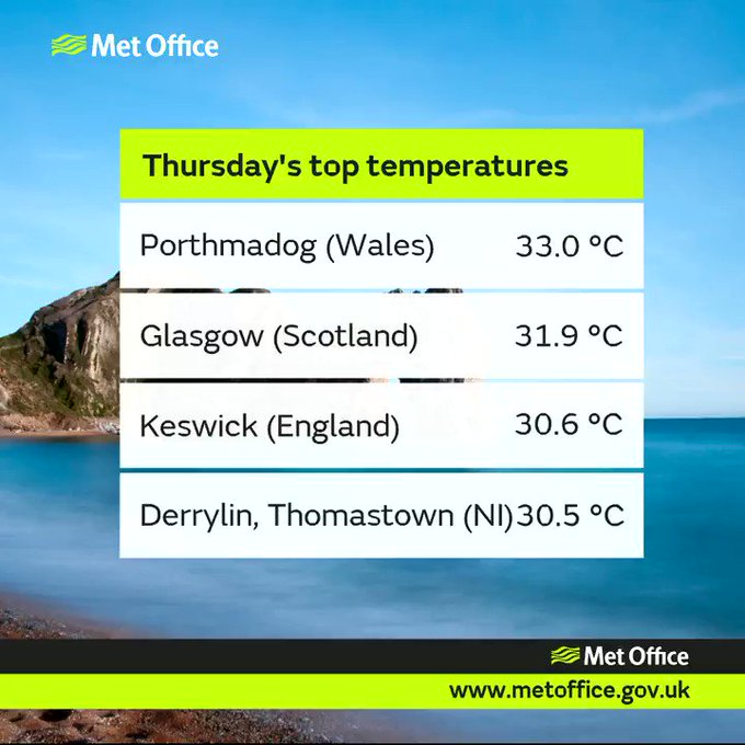
The U.K. recorded its hottest day of the year for a fourth straight day on Thursday. Temperatures soared to 33.0 C (91.4 F) in Portmadog, Wales.
This topped temperatures of 31.9 C (89.4 F) on Wednesday and 30.6 C (87.2 F) in Porthmadog on Tuesday and 30.1 C (86.2 F) in the London suburb of Hampton on Monday.
All 4 UK home nations have topped 30 Celsius today, with some local temperature records being broken #heatwave
Whilst Friday may fall short of being declared the hottest day of the year, it will not mean an end to the heat wave.
The official criteria of a heat wave, which is defined as five consecutive days with the daily maximum temperature exceeding the average high by 5 C (9 F), will occur in many locations across the country this week.
High temperatures across Greater London are forecast to reach or surpass 27 C (80 F) each day into at least Sunday. A typical high in the city during the final days of June is 21 C (69 F).
Temperatures across much of England, as well as Wales and northward through Scotland and Northern Ireland, are likely to soar to between 4 and 8 C (7 and 14 F) above average for late June.
Factoring in plenty of sunny spells, light wind and an increase in humidity levels, AccuWeather RealFeel® Temperatures will be several degrees above the actual temperature.

Residents will have to continue to use extreme care with barbeques, cigarette butts and sparks to avoid igniting fires amid the tinder dry vegetation.
Greater Manchester Fire and Rescue Service reported that more than 100 firefighters were joined by troops from the Royal Regiment of Scotland to battle the moorland blazes on the hills in Tameside on Thursday.
BBC News reports that the Saddleworth Moor blaze is currently under control. However, the firefighters are also dealing with other serious fires, including one in Rochdale.
Temperatures are expected to climb between 25 and 27 C (upper 70s F) in Manchester into the weekend.
RELATED:
United Kingdom Weather Center
MinuteCast® for your location
Interactive United Kingdom weather radar
United Kingdom Weather Center
MinuteCast® for your location
Interactive United Kingdom weather radar
Regardless of whether or not the upcoming pattern will meet the official criteria of a heat wave in your area, people will need to take precautions to avoid straining themselves in the heat.
Due to this being a long-duration heat event, there will be an elevated risk for heat-related illnesses, especially for the youth and elderly.
Anyone going outside to enjoy the warm, dry and sunny weather will need to wear plenty of sun cream and light-colored, loose-fitted clothing. People should also drink plenty of water in order to stay hydrated.
Remember never to leave a child or pet in a sealed vehicle without air conditioning even for a short period of time.
People looking to avoid the heat will want to travel east this week. “The coolest locations this week will be across the eastern coasts of the U.K. as a cooling wind from the North Sea limits the heat,” according to AccuWeather Meteorologist Tyler Roys. Cloudy spells will accompany the push of cooler air.
A slow-moving storm system will bring the risk for showers and thunderstorms from Sunday into early next week. This will knock back the heat; however, temperatures are expected to remain near to above normal during the first week of July.
Potent storm to bring heavy rain, snow to Chile and Argentina this weekend
By Eric Leister, AccuWeather senior meteorologist
June 28, 2018, 12:51:55 PM EDT
As winter continues across Chile and Argentina, a storm will unleash heavy rain and mountain snow this weekend.
Rain will spread into the central coast of Chile Saturday night before increasing in intensity on Sunday.
The heaviest rain is expected across central Chile from La Serena southward to near Concepcion.

This includes Valparaiso and Santiago, where flooding is possible. Areas of rugged terrain will be at risk for mudslides.
"This will be the heaviest rainfall of the season so far for Santiago," said AccuWeather Senior Meteorologist Rob Miller.
Rainfall may amount to around 25 mm (1 inch) in Santiago with 50-75 mm (2-3 inches) in the foothills where localized flooding and mudslides can occur.
"Motorists may face slick road conditions as the rain initially arrives and mixes with oil residue left behind during the recent dry spell," AccuWeather Senior Meteorologist Kristina Pydynowski said.
The rain will be beneficial for areas that do not experience flooding, as much of the region has received 50 percent or less of their normal rainfall so far this year.
Cool air accompanying the storm can hold temperatures on Sunday to the lower teens C (50s F).
Heavy snow will fall in the higher elevations, including many popular ski resorts, across central Chile. Travel to these resorts will be impaired Saturday night into Monday; however, the fresh snow will be welcomed by skiers in the region.
Farther east, this storm system will also impact parts of northern Argentina and Uruguay.
Rain and thunderstorms will become widespread from Rosario to Buenos Aires and Montevideo late Saturday night into Sunday.
The heaviest rainfall is expected during the day on Sunday and could result in some localized flooding and travel delays.
Much cooler weather will follow this storm across Argentina and Uruguay, as well.
High temperatures on from Tuesday through Thursday will range from 13-15 C (56-59 F) in both Buenos Aires and Montevideo.
Most intense heat to peak ahead of July 4th in northeastern US
By Alex Sosnowski, AccuWeather senior meteorologist
June 28, 2018, 3:09:43 PM EDT
Surging heat and humidity combined with light winds will create a dangerous heat wave in the northeastern United States, which is forecast to be at its peak this weekend into early next week.
However, even during and after Independence Day, hot and humid weather will roll on.

People who live for hot weather will be pleased, while some senior citizens, young children, folks with respiratory ailments and those who must do manual labor may be especially at risk.
How hot will it get?
Daytime temperatures will surge into the 90s F and AccuWeather RealFeel® Temperatures are projected to top 100 in the northeastern United States during the afternoon hours from Saturday through Monday.

While record temperatures are in the upper 90s to near 100 this time of the year, a few locations may still flirt with record highs, such as across New York state, Pennsylvania and New Jersey.

Neighborhoods will be abuzz with the sound of air conditioners and fans, while people will flock to area beaches, pools and water parks by the hundreds of thousands.
Why is this heat wave a concern?
Late June and early July are well within the realm of solar summer, which is the three months of the year with the highest sun angle. The summer solstice was on June 21.
People who plan on spending time outdoors, such as at the beach, pool or ballpark, should remember to use sunscreen.
People of all ages, regardless of their health and physical activity, indoors and out, will need to stay hydrated. Intake of alcoholic beverages should be limited, especially when there is no means to keep cool, such as in air conditioning.

Heat will build to dangerous levels in the urban areas of the major cities. The vast expanse of concrete, pavement and brick will give off heat through the night. Cooling stations, where people can escape from the heat for several hours, are warranted.
While late-model vehicles have much lower emissions than automobiles from back in the 1960s and 70s, air stagnation and poor air quality are a concern with this heat wave.
"Extended periods of sunny, hot, humid and calm weather are the perfect breeding ground for poor air quality conditions," according to AccuWeather Meteorologist Faith Eherts.
Ozone will be the main air quality threat, which peaks during the afternoon hours when sunlight is the strongest.
RELATED:
Heat exhaustion vs. heatstroke: What are the warning signs and how should you react?
4 ways medications make you more vulnerable to heat and sun
5 foods to help you beat the heat
5 ways people stayed cool before air conditioning was invented
Sweltering summer heat wave to take aim at Midwest into Sunday
Heat exhaustion vs. heatstroke: What are the warning signs and how should you react?
4 ways medications make you more vulnerable to heat and sun
5 foods to help you beat the heat
5 ways people stayed cool before air conditioning was invented
Sweltering summer heat wave to take aim at Midwest into Sunday
"The highest ozone concentrations are likely to be found in the vicinity of major highways, such as Interstate 95, and large metropolitan areas," Eherts said.
"Residents and visitors are encouraged to use public transportation, limit the use of grills, lawnmowers and other combustion engine power equipment and avoid prolonged periods of exertion outdoors."
Little to no rain in the offing
In terms of rainfall, most of the time from Saturday through the Fourth of July will be free of rain.
Exceptions may be a shower or thunderstorm that affects parts of northern New York state and northern New England on Saturday.
Spotty afternoon thunderstorms may develop from northern New England to the eastern Great Lakes and western slopes of the Appalachians on Monday.
Widely separated afternoon and evening storms may dot the region on Tuesday and Wednesday.
Dog days of summer are here
Temperatures are expected to trend downpours slightly on Tuesday and Independence Day.
However, temperatures are likely to remain at or above average through next week and into next weekend.
"We expect highs to be within a few degrees of 90 in the mid-Atlantic, I-95 corridor during the middle to latter part of next week," according to AccuWeather Long-Range Meteorologist Max Vido. "Highs will be mainly in the 80s over the mountains."
There may be a sneaky push of cool air from eastern Canada or the Atlantic Ocean that brings a break from the heat for a day or so. Most days, sea breezes will be limited to the beaches and a mile or so of the coast.
There are no signs any big blasts of cool weather with low humidity any time soon, so it would seem the dog days of summer are upon us.
Remember to conserve electricity by turning off the fan or air conditioner when not at home or in the office.
What is 'June gloom' and how does it affect Southern California?
By Kyle Elliott, AccuWeather meteorologist
The marine layer is created by rising air over the hot, desert regions of the Southwest. This rising air creates a vacuum. Cool, moist air is then drawn in from the Pacific Ocean along the coastline of California by a subtle breeze.
The phenomenon known as "June gloom" plays a major role in altering the climate of coastal regions of Southern California when compared to areas just a few dozen miles farther inland.
June gloom refers to a band of low clouds and fog, known as the marine layer, that develops on an almost daily occurrence within a few miles of the southern California coastline during the overnight and morning hours.
"June gloom is so named as June can be one of the months that tends to have more persistent marine clouds than any other month," AccuWeather Western U.S. Weather Expert Ken Clark said.
“This phenomenon can really occur any month, especially from May through September, but it’s the persistence that is why we talk about this during the month of June," he added.

The marine layer is created by rising air over the hot, desert regions of the Southwest. This rising air creates a vacuum. Cool, moist air is then drawn in from the Pacific Ocean along the coastline of California by a subtle breeze.
This cool, moist ocean flow leads to the formation of low clouds once the sun goes down and temperatures begin to fall. When the temperature dips to a certain point but the amount of moisture in the air holds steady, the humidity rises and clouds begin to form.
RELATED:
Clean Beaches Week: Experts share tips on protecting beaches, marine life
4 summer beach hazards that can seriously harm or kill you
Planning a surfing trip? Find out when, where to catch the best waves
Public pools and hot tubs may pose serious health hazards to your family, CDC says
Clean Beaches Week: Experts share tips on protecting beaches, marine life
4 summer beach hazards that can seriously harm or kill you
Planning a surfing trip? Find out when, where to catch the best waves
Public pools and hot tubs may pose serious health hazards to your family, CDC says
Once humidity reaches its maximum level, these clouds can thicken and lower, and fog can also form.
It is when the temperature difference between the ground and areas higher up in the atmosphere is greatest that the marine layer takes the longest to burn off.
"During the late morning and afternoon on most days, sunshine above the clouds helps to drag drier air higher into the atmosphere down to the surface, thus scouring out the clouds," AccuWeather Senior Meteorologist Alex Sosnowski said.
Once this process reverses after sundown, the marine layer tends to return and thicken, Sosnowski said.
"The marine layer can lead to huge differences in temperature between the coast to areas farther inland due to the delayed clearing at the coast, and it’s not uncommon to have it cloudy and in the 60s at the beaches while it’s in the 80s or even 90s only 10-20 miles inland," according to Clark.
For residents that live farther inland and want to escape the scorching heat, June gloom exists as an option to beat the heat and escape to the much cooler beaches. Once the clouds burn off during the afternoon, temperatures typically still get high enough (into the 60s and 70s) to enjoy the beach.
The marine layer helps to greatly moderate the climate along the coastline of Southern California. The average high in Los Angeles during the month of June remains within a couple of degrees of 70, and the average low hovers around 60.
About 50 miles farther inland, the average high in Riverside reaches the lower 90s by month's end with lows in the upper 50s.
Severe storms to take aim from Missouri to Alabama, Georgia into Thursday night
By Renee Duff, AccuWeather meteorologist
June 28, 2018, 9:00:24 PM EDT
A narrow corridor from the mid-Mississippi Valley to the interior Southeast will be at risk for severe thunderstorms into Thursday night.
Locally severe thunderstorms rattled and drenched communities in north-central Missouri and eastern Tennessee, northern Georgia and the western parts of the Carolinas during Thursday morning and early Thursday afternoon.
Over 175,000 electric customers were without power as the storms advanced southward across Alabama on Thursday afternoon.
A tornado-warned thunderstorm moved through the St. Louis area on Thursday evening; however, no tornado has been confirmed. The same storm also brought winds over 55 mph, leading to thousands of power outages.
High wind, heavy rain send trampoline flying in Chapel Hill, Tenn. News 2 #WeatherAuthority
Damage in Vincent (Shelby County)… on CR 466… photo from Samecca McCrimon
The swath of storms will change its orientation somewhat, but will continue to affect the same general part of the nation as recent days. During Thursday night, the storms will cruise along a north to south path, rather than northwest to southeast.
"Areas from middle Tennessee to Alabama, western Georgia and northern Florida will be at risk for locally damaging storms into Thursday night," according to AccuWeather Senior Meteorologist Alex Sosnowski.

"Farther to the north, a new batch of heavy, gusty and locally severe thunderstorms move out of southeastern Iowa and into part of western and southern Illinois and areas of Missouri along the Mississippi River," Sosnowski said.
"Late Thursday night, this batch of storms may return downpours to parts of western Kentucky and northwestern Tennessee."
Damaging winds, hail and downpours that can drop a quick inch or more of rain are expected to be the most widespread impacts from the storms.
Even in areas outside of the main corridor of severe storms will be at risk for localized torrential downpours, flash flooding and gusty winds.
Due to localized flooding, there are various closures throughout the park, including the Elkmont campground. Drive safely, and for more information on road closures, call the road closures hotline 865-436-1200 #2 #2 or text "follow smokiesroadsnps" to 40404.
Any area that has been hit with repeating downpours in recent days can quickly experiencing flooding. Streams are running high from the southern Appalachians to the middle part of the Mississippi Valley.
In addition, trees that have been weakened from the rain and wind of prior storms this week will be more susceptible to falling. A few communities could experience extensive power outages.
RELATED:
7 lightning safety tips if you’re caught outside during a thunderstorm
Is it safe to talk on your cell phone during a thunderstorm?
Why washing dishes or showering during a storm can be extremely dangerous
7 lightning safety tips if you’re caught outside during a thunderstorm
Is it safe to talk on your cell phone during a thunderstorm?
Why washing dishes or showering during a storm can be extremely dangerous
People outside or on the roadway should stay up to date on the latest severe weather alerts, as the storms may blow through quickly with little notice.
Towering, darkening clouds and sudden gusts of wind can be signs that a storm is approaching and that shelter should be sought immediately.
The risk of organized severe weather over the Southeast will ease somewhat on Friday, though a few storms across the Deep South could turn heavy and gusty on the local level.
Subscribe to:
Posts (Atom)
Man missing at sea for nearly 2 weeks found alive in life raft off Washington coast
One of two men missing at sea for nearly two weeks was found alive on Thursday by a Canadian fishing boat in a life raft in Canadian water...
-
Jonathan Erdman Published: October 26, 2023 Louisiana and Mississippi are experiencing their most widespread "exceptional" droug...
-
Chris Dolce Published: April 6,2020 Tropical Cyclone Harold underwent a last-minute burst of intensification before it hit Vanuatu an...
-
Linda Lam Published: August 11, 2020 Severe weather, including tornadoes, derechos and flash flooding, can result in dangerous conditions ...