Saturday, October 2, 2021

Wettest Summer on Record for the Northeastern US? You Decide

The 2021 summer season that has just ended proved to be characterized by a very active weather pattern due to a very active hurricane season for the Atlantic region with the remnants of both Hurricane Henri that hit mid-August and Hurricane Ida that hit 2 weeks later August 30-September 1, 2021 providing a good chunk of the rainfall totals for the past couple of months in particular for certain Northeastern US cities. Here's the rainfall totals for select cities in the Northeastern US over the past 3 months since July 1,2021 from weatherunderground.com


New York City (La Guardia Airport)


July 2021: 10.13 inches

August 2021: 8.82 inches

September 2021: 8.75 inches


Total: 27.70 inches


New York City (Central Park):


July 2021: 11.1 inches

August 2021: 9.37 inches

September 2021: 10.03 inches


Total: 30.50 inches


Boston,MA:


July 2021: 10.22 inches

August 2021: 7 inches

September 2021: 7.47 inches


Total: 24.69 inches


Hartford,CT:


July 2021: 10.66 inches

August 2021: 8.8 inches

September 2021: 6.81 inches


Total: 26.27 inches


Portland,ME:


July 2021: 9.63 inches

August 2021: 2.2 inches

September 2021: 4.25 inches


Total: 16.08 inches


Philadelphia,PA:


July 2021: 6.76 inches

August 2021: 6.18 inches

September 2021: 4.61 inches


Total: 17.55 inches


Baltimore,MD: 


July 2021: 3.6 inches

August 2021: 4.33 inches

September 2021: 6.04 inches


Total: 13.97 inches


Washington,DC:


July 2021: 4.27 inches

August 2021: 9.07 inches

September 2021: 4.03 inches


Total: 17.37 inches


Rainfall Totals from most to least since July 1,2021:


1. New York City (Central Park): 30.50 inches

2. New York City (La Guardia Airport): 27.70 inches

3. Hartford,CT: 26.27 inches

4. Boston,MA: 24.69 inches

5. Philadelphia,PA: 17.55 inches

6. Washington,DC: 17.37 inches

7. Portland,ME: 16.08 inches

8. Baltimore,MD: 13.97 inches 


Hurricane Sam to Generate High Surf Along U.S. East Coast as it Moves Away From Bermuda

 weather.com meteorologists

Published: October 2, 2021


Hurricane Sam won't threaten the East Coast but will be a wave generator along those beaches through the weekend as it brings tropical storm conditions to Bermuda.

Sam will remain a strong hurricane as it moves northeastward over the next few days into the north Atlantic.

Article imageCurrent Satellite

Forecast models suggest Sam is likely to track well to the south and east of Newfoundland, Canada early next week, then become a strong post-tropical storm over the North Atlantic Ocean.

This track will keep Sam well away from the U.S. East Coast.

Enjoy The Outdoors With This Portable Outdoor Fan (SPONSORED)

Sam will weaken this weekend into early next week.

Article imageCurrent Info, Projected Path

Sam will generate high surf and rip currents along the East Coast this weekend, as Hurricane Larry did earlier this month despite also passing east of Bermuda.

Keep this in mind if you're headed to an East Coast beach this weekend. Rip currents have already claimed 81 lives in the U.S. so far this year, according to the National Weather Service.

(MORE: The Danger of Rip Currents)

Sam's Recap

Sam became the eighteenth named storm of the 2021 Atlantic hurricane season last Thursday, the second earliest "S" storm in Atlantic Basin history, behind only 2020's Sally, according to NHC hurricane specialist Philippe Papin.

Sam became the fourth major hurricane of the 2021 Atlantic season on Saturday after it rapidly intensified. Maximum sustained winds in Sam increased from 85 mph to 140 mph in the 24 hours ending Saturday 5 p.m. EDT.

Article imageTrack History of Hurricane Sam

The powerful hurricane continued to gain strength last Sunday and reached a maximum intensity of 155 mph while spinning several hundred miles to the east-southeast of the Leeward Islands, according to a Sunday evening Hurricane Hunter reconnaissance mission.

Sam then weakened overnight because of an eyewall replacement cycle, a process in which an intense hurricane replaces its eyewall with an outer eyewall.

Once that cycle was complete, an eye appeared again in infrared satellite imagery by Monday afternoon.

Sam joined 2019's Hurricane Lorenzo as the only Category 4 or stronger hurricanes so far east this late in the hurricane season, according to NOAA-CIRES researcher Sam Lillo.

Sam has been a major hurricane for more than a week, the first to reach such a duration since 2016's Hurricane Matthew.

The Weather Company’s primary journalistic mission is to report on breaking weather news, the environment and the importance of science to our lives. This story does not necessarily represent the position of our parent company, IBM.

The Weather Company’s primary journalistic mission is to report on breaking weather news, the environment and the importance of science to our lives. This story does not necessarily represent the position of our parent company, IBM.

Infrastructure Bill Would Direct Billions Toward Climate Change Mitigation

 Jan Wesner Childs

Published: October 1, 2021
Article imageA man fills a water tank intended for drought-affected livestock from a community rancher's well on the Navajo Nation on July 4, 2021, south of Tuba City, Arizona. A trillion-dollar infrastructure bill proposed by President Joe Biden provides funding to help tribal communities mitigate the impacts of climate change.

The trillion-dollar infrastructure bill before Congress contains several provisions that would direct billions of dollars toward rebuilding and shoring up the nation's infrastructure against climate change and mitigating the impacts of global warming.

The bill would authorize nearly $550 billion in new funding for public works projects over the next five years, according to the White House, in addition to existing funding.

Among the provisions are overhauling the power grid, boosting climate research and weather forecasting, money for low-emissions buses and other transit vehicles, and making roads and bridges more resilient.

The bill also highlights assistance to communities of color and tribal communities, both of which the federal government says are more likely to suffer the effects of weather disasters and climate change.

The bill was scheduled for a vote Thursday, but as of Friday afternoon no action had been taken.

(MORE: Why California Wildfires Are Particularly Destructive in Fall)

Included in the funding would be $60 billion to upgrade power infrastructure with thousands of miles of new transmission lines, according to a White House fact sheet. The goal would be to make the grid more resilient and facilitate the expansion of renewable energy. The bill would also create what the White House calls a "Grid Deployment Authority" to guide the overhaul. Hurricanes, heat waves and winter storms have all stressed the power grid in recent years, resulting in millions of power outages and, according to the Department of Energy, costing the U.S. economy up to $70 billion a year.

Meanwhile, flooding, wildfires, landslides and other disasters are taking a toll on the nation's highways, bridges and other infrastructure.

The bill includes $110 billion of new funds for repairing and rebuilding roads and bridges and other major projects, with a focus on climate change mitigation, resilience, equity and safety. The funding would include $40 billion alone for bridge repair, replacement and rehabilitation.

The White House projects the initiatives set forth in the bill would add an average of about 2 million jobs per year over the next decade, according to the Associated Press. It's considered a cornerstone of President Joe Biden's administration.

The bill would be funded with $210 billion in unspent COVID-19 relief aid and $53 billion in unemployment insurance aid that remains unused by states that halted the program. The rest of the funds would come from several other smaller pots of money.

Critics have expressed concerns over the bill's size, scope and financing. The Congressional Budget Office said it would add $256 billion to deficits in the next 10 years, the AP reported.

Article imageMudslides and flooding in an area with wildfire burn scars shut down Interstate 70 through Glenwood Canyon, Colorado, in July and August 2021. Experts say climate change helped fuel the conditions that led to the disaster.

The Senate approved the bill in August in what was considered a rare bipartisan move, after months of political wrangling. The House vote was on hold after more objections and delays to try and ensure enough votes to pass.

Here's a look at some of the other major climate-related provisions, according to the bill text and White House fact sheet:

-$105 billion for modernizing and expanding transit and rail infrastructure, including replacing thousands of buses with zero-emissions vehicles.

-$17 billion for port infrastructure and $25 billion for airports. The money would be earmarked for repair and maintenance backlogs, reducing congestion and lowering emissions.

-$11.6 billion to the U.S. Army Corps of Engineers for construction projects related to flood control, dredging and other infrastructure. Funding would also be provided for flood control and coastal emergencies.

-$7.5 billion to build a national network of charging stations for electric vehicles.

-$3.5 billion to the Federal Emergency Management Agency for flood mitigation actions and assistance.

-$3.5 billion to the Department of Energy's Weatherization Assistance Program, which aims to reduce energy costs for low-income households by improving energy efficiency at home.

-$2.6 billion to the National Oceanic and Atmospheric Administration, the nation's lead scientific and regulatory agency on climate and weather. The funds would include $492 million for coastal and inland flood and inundation mapping and forecasting along with "next-generation water modeling activities;" $50 million for wildfire prediction, detection and observation; and $80 million for supercomputing infrastructure used for weather and climate model development to improve forecasting and detection of droughts, floods and wildfires.

-$216 million for the Bureau of Indian Affairs, more than half of which would be designated for "community relocation." There are 567 federally recognized tribes in the U.S. representing more than 5 million people, and many live on lands taking the brunt of climate change impacts, according to data from the federal government's U.S. Climate Resilience Toolkit. In Alaska, for example, rising temperatures are melting sea ice and glaciers and thawing permafrost. In the western part of the contiguous U.S., tribal populations face drought and water challenges. These changes in climate affect homes, communities, schools, water supplies and food supplies. Some communities are already moving to higher ground.

The Weather Company’s primary journalistic mission is to report on breaking weather news, the environment and the importance of science to our lives. This story does not necessarily represent the position of our parent company, IBM.

The Weather Company’s primary journalistic mission is to report on breaking weather news, the environment and the importance of science to our lives. This story does not necessarily represent the position of our parent company, IBM.


October Temperature Outlook: Warmer Than Average Temperatures Expected for Much of the Lower 48

 Linda Lam

Published: September 30, 2021


October may not feel like fall in much of the northern tier of the United States.

Temperatures will be the most above average from the northern High Plains through the Midwest into the Northeast in October, according to the latest outlook from The Weather Company, an IBM Business. Above-average temperatures will extend southward into parts of the Southern Plains and the Southeast.

Cooler than average conditions are expected for much of California and southern Arizona, while much of the Northwest, Southwest and portions of the Gulf Coast and Florida may trend near to slightly cooler than average in October.

Article image

One important factor in this temperature outlook is the development of La Niña, which looks likely to emerge this fall into the winter. La Niña is the periodic cooling of the equatorial Pacific Ocean waters, which depending on its strength, can influence weather patterns across the globe, including in the U.S.

Above-average temperatures are typically experienced across much of the Lower 48 in Octobers when La Niña has developed. This is especially true from the Rockies into the Midwest. But areas along the Gulf Coast and portions of the West Coast often experience cooler than average conditions in La Niña Octobers. This overall theme closely matches the current October outlook.

Article image

The typical October La Niña pattern also correlates well with what forecast models are showing for much of October.

Current models depict an upper-level ridge or northward bulge of the jet stream over a good chunk of the Lower 48, indicating warmer than average temperatures. A trough or southward dip in the jet stream is also likely over parts of the West at times, suggesting cooler than average temperatures.

"We've made further warmer adjustments to the October forecast to be more in line with our medium-range and subseasonal forecasts, which are in line with warmer historical La Niña aggregates," Todd Crawford, director of meteorology at Atmospheric G2 pointed out.

The agreement between recent computer model forecasts for October and what has typically been the case in La Niña Octobers gives higher confidence in the current October outlook, Crawford notes.

Article image

Typical October Temperatures

Crisp temperatures become more common across the northern tier of the U.S. in October, with average highs in the 50s and 60s. Warmer than average temperatures there suggest that a milder month may be in store.

Above-average temperatures in parts of the South indicate a warm October may make it feel less like fall.

However, in areas of the West where below-average temperatures are anticipated a chillier October may be ahead.

Article image

Many areas from the West into the Midwest into parts of the Northeast often experience the first freeze of the season by the end of October.

But warmer than average temperatures may mean milder mornings will last a bit longer for much of the Lower 48.

Chillier mornings than is typical for October could occur in parts of the West and near the Gulf Coast where a cooler than average trend is anticipated.

Article image

The Weather Company’s primary journalistic mission is to report on breaking weather news, the environment and the importance of science to our lives. This story does not necessarily represent the position of our parent company, IBM.

The Weather Company’s primary journalistic mission is to report on breaking weather news, the environment and the importance of science to our lives. This story does not necessarily represent the position of our parent company, IBM.

October Is a Month of Changes – Here's What to Watch For

 Linda Lam

Published: September 30, 2021


October is full of weather changes as we transition from summer to winter.

The amount of sunlight declines during the fall and temperatures get colder, which leads to the first freeze and snowfall of the season. There's also all of that beautiful foliage.

October weather is not all delight. Serious weather threats like hurricanes, wildfires and powerful storms are also concerns.

First Freeze of the Season

Temperatures begin to dip toward the freezing mark farther south as October progresses.

The first 32-degree low temperatures are usually experienced before the month begins in parts of the higher elevations of the West and near the Canadian border.

In October, the first freeze of the season occurs across much of the interior Northeast, Midwest and the Northern and Central Plains.

Areas as far south as the Smoky Mountains of Tennessee and North Carolina, the Texas Panhandle and northern New Mexico and Arizona experience their average first freeze by the end of the month.

(MORE: Here's the Earliest You Could See Freezing Temperatures)
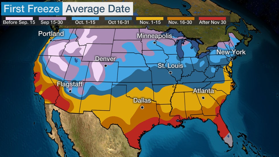
Article imageAverage First Freeze

Fall Foliage Peaks

October is when the large majority of the Northeast, Midwest and West sees the best, most vivid fall colors. However, areas closer to the mid-Atlantic coast and farther south often wait until early November to experience peak fall foliage.

The picturesque color is due to crisp, cool nights and fewer daylight hours.

(MAPS: Current Fall Foliage Status)

Article imageTypical time of peak fall colors.

First Snowfall of the Season

Increasingly cold air also increases the chance for snow in parts of the Lower 48.

Accumulating snow is usually restricted to the highest peaks of the Rockies and Alaska in September.

In October, the first snowfall of the season typically happens in much of the Rockies, as well as parts of the Western and Northern Plains. The northern Great Lakes also usually see their first snow of the season in October.

Parts of the higher elevations of the Appalachians, Adirondacks and the Green and White Mountains often see snowflakes this time of year.

The average first measurable snow (at least 0.1 inches) falls in October in several cities, including Caribou, Maine; Marquette, Michigan; Duluth, Minnesota; Bismarck, North Dakota; Great Falls, Montana; Denver; and Anchorage, Alaska.

Last October was full of early-season wintry woes.

In the last week of the month, snow fell as far south as Midland, Texas, and a crippling ice storm knocked out power to hundreds of thousands in Oklahoma, including the Oklahoma City metro area – all while Hurricane Zeta was hammering Louisiana and the Southeast.

Multiple northern locales had their snowiest October on record in 2020, including Great Falls, Montana; Spokane, Washington; St. Cloud, Minnesota; and Rhinelander, Wisconsin.

Article imageAverage Date Of First Measurable Snowfall

Tropical Threats

Hurricanes and tropical storms remain serious concerns through October.

From 1851 through 2020, 33 hurricanes made a landfall in Florida in October, dwarfing the state with the second-highest number: Louisiana with 12.

In South Florida, October is the month with the most hurricane direct hits. According to NOAA's Best Track Database, 24 October hurricanes have passed within 100 nautical miles of downtown Miami since 1851.

Most recently, Hurricane Michael made its catastrophic Category 5 landfall on the Florida Panhandle on Oct. 10, 2018.

No hurricanes hit Florida in October 2020. However, hurricanes Delta and Zeta both made landfall in Louisiana during the month at Category 2 and 3 intensity, respectively.
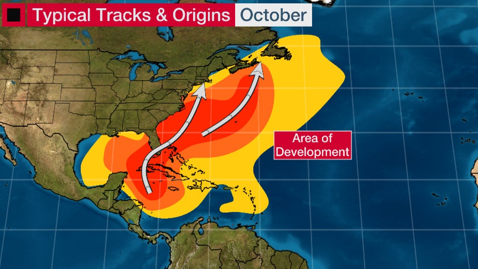
Article imageTypical tracks and origins of tropical cyclones in October.

Santa Ana Winds, Wildfire Concern

Southern California's infamous offshore winds, known as Santa Ana winds, typically kick into gear by October, according to a 2017 climatology study.

Fueled by a combination of high pressure in the Great Basin and the southward return of the jet stream, these hot, intense winds squeeze through passes and canyons of the L.A. Basin at times, most commonly from September through March.

What makes them particularly dangerous in October is that soil moisture is at its driest after the summer dry season. These Santa Ana winds can whip either an existing wildfire or just-developed small brush fire into an inferno.

(MORE: Fall is a Dangerous Time For California Wildfires)

Article imageThe Bobcat Fire, burning in the San Gabriel Mountains northeast of Los Angeles, pushed toward Mt. Wilson on Tuesday, Sept. 22, 2020.

Powerful Storms, Severe Weather

Big October storms are also not unusual.

Superstorm Sandy in 2012 was the ultimate recent example of a massive October storm. One of Sandy's unique impacts was its feet of snow burying parts of the Appalachians.

More recently in 2019, a bomb cyclone lashed the Northeast with strong winds and heavy rainfall.

Other big October storms:

-Winter Storm Atlas hammered the High Plains with blizzard conditions in early October 2013.

-The "Snowtober" storm knocked out power to over 3 million in the Northeast in late October 2011.

-The "Octobomb" storm set all-time low-pressure records in Minnesota and Wisconsin and spawned severe thunderstorms and tornadoes in the Ohio Valley and mid-South.

-Heavy lake effect snow damaged trees and knocked out power to 1 million customers in Buffalo, New York, in mid-October 2006.

The Weather Company’s primary journalistic mission is to report on breaking weather news, the environment and the importance of science to our lives. This story does not necessarily represent the position of our parent company, IBM.

The Weather Company’s primary journalistic mission is to report on breaking weather news, the environment and the importance of science to our lives. This story does not necessarily represent the position of our parent company, IBM.

This Date in Weather History for October 2,2021

 Weather History

For Saturday, October 2,2021


1882 - An early season windstorm over Oregon and northern California blew down thousands of trees and caused great crop damage in the Sacramento Valley. (David Ludlum)
1959 - A tornado struck the town of Ivy, VA (located near Charlottesville). Eleven persons were killed, including ten from one family. (The Weather Channel)
1980 - The temperature at Blue Canyon, CA, soared to 88 degrees, an October record for that location. (The Weather Channel)
1981 - Severe thunderstorms raked Phoenix, AZ, with heavy rain, high winds, and hail up to an inch and a half in diameter, for the second day in a row. Thunderstorms on the 1st deluged Phoenix with .68 inch of rain in five minutes, equalling their all-time record. (The Weather Channel)
1987 - A fast moving cold front produced snow flurries from Minnesota to the Appalachian Mountains, and gale force winds behind the front ushered cold air into the Great Lakes Region. Valentine NE reported a record low of 25 degrees. Temperatures recovered rapidly in the Northern High Plains Region, reaching the lower 80s by afternoon. Jackson, WY, warmed from a morning low of 21 degrees to an afternoon high of 76 degrees. (The National Weather Summary)
1988 - Early morning thunderstorms in Georgia produced three inches of rain at Canton and Woodstock. (The National Weather Summary)
1989 - Flooding due to thunderstorm rains in the southeastern U.S. on the last day of September and the first day of October caused the Etowah River to rise seven feet above flood stage at Canton GA. Thunderstorms produced up to ten inches of rain in northeastern Georgia, with six inches reported at Athens GA in 24 hours. One man was killed, and another man was injured, when sucked by floodwaters into drainage lines. (The National Weather Summary) (Storm Data)

This Date in Weather History for October 1,2021

Weather History
For Friday, October 1,2021


1752 - The second severe hurricane in two weeks hit the Carolinas. The Onslow County Courthouse was destroyed along with all its records, and Beacon Island disappeared. (David Ludlum)
1893 - The second great hurricane of the 1893 season hit the Mississippi Delta Region drowning more than 1000 persons. (David Ludlum)
1987 - A blast of cold arctic air hit the north central U.S. An afternoon thunderstorm slickened the streets of Duluth MN with hail and snow, and later in the afternoon, strong northerly winds reached 70 mph. Unseasonably warm weather continued in the Pacific northwest. Afternoon highs of 90 degrees at Olympia WA, 92 degrees at Portland OR, and 89 degrees at Seattle WA, were records for the month of October. For Seattle WA it marked the twenty- first daily record high for the year, a record total in itself. (The National Weather Summary)
1988 - Afternoon and evening thunderstorms produced severe weather across central Oklahoma and the eastern half of Texas. Thunderstorms in Texas produced softball size hail northwest of Nocona, and baseball size hail at Troy and Park Springs. (The National Weather Summary) (Storm Data)
1989 - Thunderstorms produced severe weather in the southeastern U.S. through the daytime and evening hours. Severe thunderstorms spawned eleven tornadoes, with seven of those tornadoes in Georgia. A tornado southwest of Moultrie, GA, killed two persons and injured a dozen others. Tornadoes also injured one person north of Graceville, FL, and two persons at Bartow, GA. (Storm Data) (The National Weather Summary)

Man missing at sea for nearly 2 weeks found alive in life raft off Washington coast

  One of two men missing at sea for nearly two weeks was found alive on Thursday by a Canadian fishing boat in a life raft in Canadian water...