Wednesday, May 5, 2021

April 2021 Tornadoes May Have Been Lowest In Any April This Century

 Chris Dolce

Published: May 2, 2021


April 2021 was one of the least tornadic Aprils in three decades, marking a complete reversal from an extremely active March and April last year.

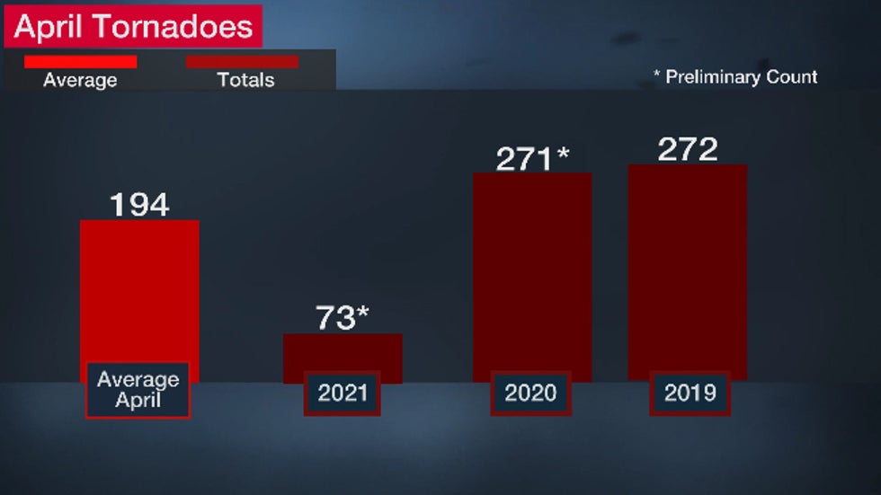
The preliminary count of tornado reports across the U.S. in April was 73, according to statistics compiled by NOAA's Storm Prediction Center (SPC). That's just over one-third of the month's 20-year average of 194 tornadoes.
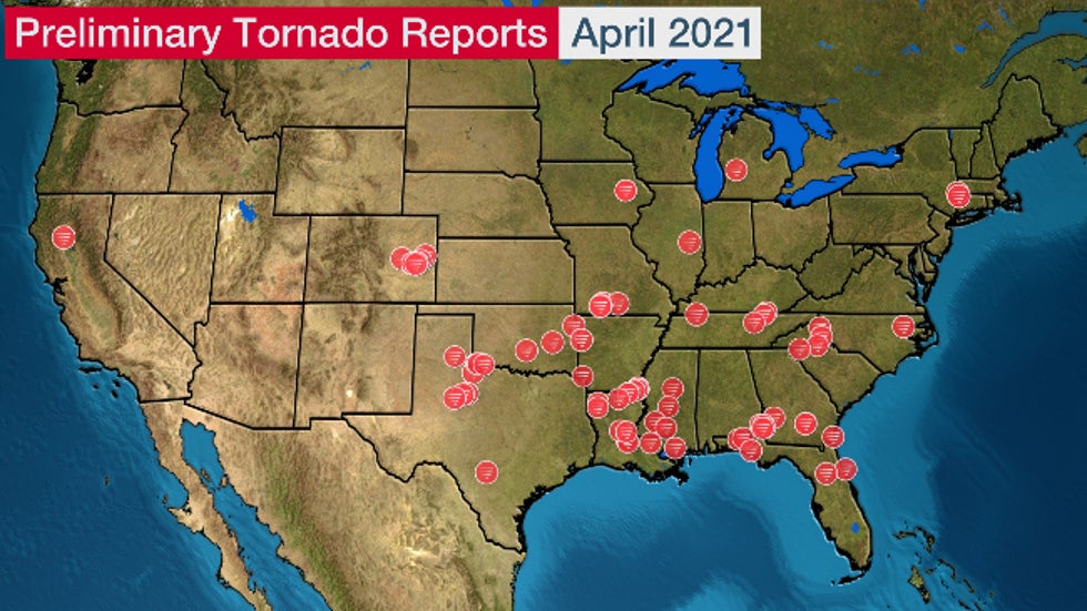
Article imageEach red icon represents a preliminary tornado report in April 2021.

The SPC said this was the fewest number of preliminary reports of any April since at least 2000.

It will take some time to firm up actual tornado counts, but if that preliminary count holds true, it could be just the fourth April since 1990 with fewer than 100 tornadoes for the month.

The last time that happened was in April 2013, which had 86 tornadoes. April 1992 (53) and 1993 (85) are the only other years in the last three decades to have fewer than 100 twisters.

April 2021 was the polar opposite of last April, which had a preliminary count of 271 tornadoes. That made it the second most tornadic April on record, but still well behind the record set in April 2011.
Article image

The SPC also found April's total severe weather reports - including reports of large hail, damaging thunderstorm winds, and tornadoes - was only half of average.

And the number of tornado watches issued in April (17) was the fourth fewest of any April since 1970.

The reason for the relative dearth of severe weather in April was simple.

Surges of cooler than average temperatures dominated parts of the central and southern U.S. for a better part of the month. That limited the availability of significant Gulf of Mexico moisture to the east of the Rockies, which is one of the key ingredients for the formation of severe thunderstorms.
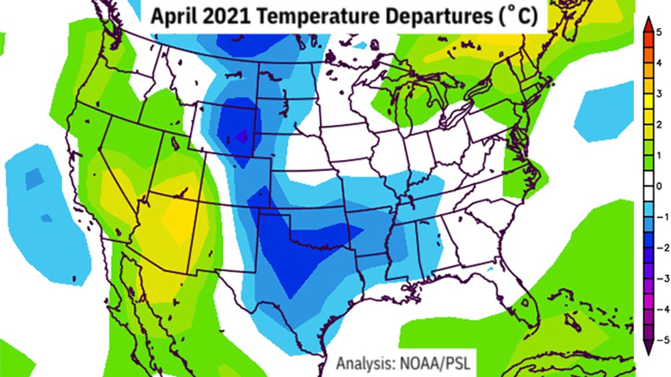
Article imageTemperature departures from average (in degrees Celsius) in April 2021. Much of the Plains states were cooler than average.

Despite this, a trifecta of major hailstorms on April 28 in Oklahoma and Texas likely inflicted over $1 billion damage combined.

Of course, this has no bearing on what will happen through the rest of spring.

May has historically been the most active tornado month in the U.S. That's because the geographical area most favorable for the development of severe thunderstorms grows larger in size as warmer temperatures become more expansive.

(MORE: Most Dangerous Time of Year For Tornadoes)

The Weather Company’s primary journalistic mission is to report on breaking weather news, the environment and the importance of science to our lives. This story does not necessarily represent the position of our parent company, IBM.

The Weather Company’s primary journalistic mission is to report on breaking weather news, the environment and the importance of science to our lives. This story does not necessarily represent the position of our parent company, IBM.

Record Warmth in the West Will Soon Be A Memory; Cooler Weekend Ahead

 Jonathan Belles

Published: May 1, 2021


A pattern change will bring cooler temperatures to the West as May begins, but not before temperatures surge to record warmth.

The jet stream will ride well into Canada into this weekend, creating widespread warming that could tie or set more than a dozen daily record highs.

Temperatures will drop from near-record highs from the inland valleys of the Los Angeles Basin to the northern Rockies, including Casper, Wyoming, Billings, Montana, and Boise, Idaho.

Warm air will last one more morning. Lows Saturday morning will be in the 40s and 50s across the Northwest and Great Basin and in the 60s and 70s in the desert Southwest into the Southern California metro areas.

Some relief is expected as May begins and a new cold front arrives.

A few showers will arrive Saturday in the Pacific Northwest, which will cool temperatures as the front arrives.

Article image

Temperatures will cool further in the Rockies by about 10 to 15 degrees as the boundary droops southward this weekend.

As the next week begins, temperatures in large sections of the northern and central Rockies will drop below average. Highs will only reach the 50s and 60s in the northern Rockies, Northern Plains and Northwest. Some higher-elevation spots, including Denver and Cheyenne, will be in the 30s and 40s on Monday.

Article imageForecast Highs

This front will bring some much-needed rain and even some late-season snow to Colorado and Wyoming as it drops south.

A foot of snow could fall in the highest peaks of the Rockies, which remain in the midst of a long-term severe drought.

(MORE: Here's How Late Into the Spring Your City Has Seen Accumulating Snow)

Article imageRain and Snow Forecast

The Weather Company’s primary journalistic mission is to report on breaking weather news, the environment and the importance of science to our lives. This story does not necessarily represent the position of our parent company, IBM.

The Weather Company’s primary journalistic mission is to report on breaking weather news, the environment and the importance of science to our lives. This story does not necessarily represent the position of our parent company, IBM.

This Date in Weather History for May 5,2021

 Weather History

For Wednesday, May 5,2021


1917 - The same storm which a day earlier produced eight inches of snow in the Texas panhandle, produced a foot of snow at Denver CO, their heaviest snow of record for the month of May. (David Ludlum)
1930 - The temperature at College Park, VA, soared from 43 degrees to 93 degrees to begin an exceptional heat wave. (Sandra and TI Richard Sanders - 1987)
1987 - Unseasonably hot weather prevailed in the western U.S. A dozen cities in California reported record high temperatures for the date. Afternoon highs of 93 degrees at San Francisco, 98 degrees at San Jose, 100 degrees at Sacramento, and 101 degrees at Redding, were the warmest of record for so early in the season. The high of 94 degrees at Medford OR was also the warmest of record for so early in the season. (The National Weather Summary)
1987 - Parts of the western U.S. were in the midst of a blistering May heat wave. The reading of 100 degrees in Downtown Sacramento CA was their earliest of record. Sacramento CA established daily record highs on nine of eleven days between the 4th and the 14th. (The Weather Channel)
1988 - A stubborn low pressure system continued to drench the eastern U.S. with rain. Thunderstorms again produced large hail in North Carolina. (The National Weather Summary)
1989 - Thunderstorms swept across Georgia and the Carolinas during the late afternoon and evening hours spawning seventeen tornadoes. A tornado at Toccoa GA injured 15 persons, and a tornado at Chesnee SC killed two persons and injured 35 others. Five tornadoes in North Carolina accounted for five deaths, 88 injuries, and sixty million dollars damage. Thunderstorms also produced baseball size hail at Lake Murray SC, and wind gusts to 78 mph at Brooklyn MD. (The National Weather Summary) (Storm Data)
1990 - A strong Pacific cold front moving rapidly inland caused weather conditions at the east end of the Strait of Juan de Fuca in Washington State to quickly change from sunny and calm to westerly winds of 60 mph and ten-foot waves. Three recreational fishing boats capsized in heavy seas off Port Angeles resulting in five deaths. In California, temperatures soared above 90 degrees across much of the state. The high of 101 degrees in downtown Los Angeles was eight degrees hotter than their previous record for the date. (The National Weather Summary) (Storm Data)

This Date in Weather History for May 4,2021

 Weather History

For Tuesday, May 4,2021


1812 - A storm produced snow from Philadelphia to Maine. A foot of snow fell near Keene NH, and in Massachusetts, nine inches fell at Waltham, located near Boston. (David Ludlum)
1917 - A late season snowstorm in northwest Texas produced up to eight inches of snow in Potter County and Armstrong County. (David Ludlum)
1922 - Austin, TX, was hit twice by tornadoes which struck within thirty minutes of each other. Twelve persons were killed in the tornadoes. (The Weather Channel)
1977 - A tornado 500 yards in width struck Pleasant Hill, MO, severely damaging the high school and grade school. Only minor injuries were reported among the more than 1000 teaches and students due to excellent warnings and prior tornado drills. (The Weather Channel)
1987 - Thunderstorms produced severe weather in the southeastern U.S., with South Carolina hardest hit. Thunderstorm winds toppled trees seventy feet high in Spartanburg County SC, and knocked homes off their foundations near Bishopville SC. (Storm Data) (The National Weather Summary)
1988 - Thunderstorms produced large hail in North Carolina, but brought welcome rains to much of the rest of the eastern U.S. Residents of New England finally saw sunshine after about a week of clouds and rain. (The National Weather Summary) (Storm Data)
1989 - Thunderstorms produced severe weather in the Southern Plains Region and the Lower Mississippi Valley. Thunderstorms spawned fifteen tornadoes, and there were 340 reports of large hail and damaging winds. Hail three inches in diameter, and 9.39 inches of rain, resulted in more than 130 million dollars damage at Monroe LA. Thunderstorm winds gusted to 100 mph at Epps LA and Fort Worth TX. A thunderstorm north of Mineral Wells TX produced high winds which unroofed a nightclub, turning it into a "topless club." (The National Weather Summary) (Storm Data)
1990 - Thunderstorms produced severe weather from the Lower Ohio Valley to Virginia and the Carolinas. A tornado at Augusta Springs VA killed two people and injured ten others, and another tornado caused 1.7 million dollars damage at Colonial Heights VA. Temp-eratures soared into the 90s in northern California. The high of 98 degrees in downtown Sacramento was their hottest reading of record for so early in the season. (The National Weather Summary) (Storm Data)

This Date in Weather History for May 3,2021

 Weather History

For Monday, May 3,2021


1978 - Persistent thunderstorms caused widespread flooding in southeastern Louisiana and extreme southeastern Mississippi. Rainfall totals of ten to thirteen and a half inches were reported around New Orleans causing the worst flooding in thirty years. The water depth reached three to four feet in several hundred homes, and total property damage was estimated at one hundred million dollars. (David Ludlum)
1987 - Thunderstorms produced severe weather in Texas, Oklahoma and Kansas. Softball size hail was reported at Center Point TX, and a tornado caused three million dollars damage near Satanta KS. Heavy snow blanketed the foothills of eastern Colorado, with 18 inches reported at Divide. (The National Weather Summary) (Storm Data)
1988 - Thunderstorms brought much needed rains to the drought- stricken central U.S. Evening thunderstorms produced large hail in North Carolina. Baseball size hail was reported west of Mooresville NC. (The National Weather Summary) (Storm Data)
1989 - Thunderstorms produced severe weather in the Southern and Central Plains Region. Thunderstorm winds gusted to 72 mph at Graford TX, and baseball size hail was reported at Graham TX and Lake Kemp TX. (The National Weather Summary) (Storm Data)
1990 - A stubborn late season storm slowly crawled across southern Colorado the first three days of the month producing heavy snow from the San Juan Mountains to the southeast plains. The storm produced up to three feet of snow in the higher elevations of southern Colorado, and 18 to 22 inches of snow along the eastern slopes of the Central Mountains of New Mexico. Pueblo CO reported a record 10.6 inches of snow for the month as a result of the storm, and a record total for the winter season of 69.6 inches. (The National Weather Summary) (Storm Data)
1999 - On May 3, 1999, an unusual confluence of atmospheric conditions in Oklahoma spawned dozens of tornadoes that swept across the state in an hours-long parade of destruction. Thousands of homes were damaged or destroyed, and 19 counties became disaster areas. The worst toll was in human lives: 44 dead, including three children. Hundreds more were injured.(http://newsok.com/may3)

This Date in Weather History for May 2,2021

 Weather History

For Sunday, May 2,2021


1899 - A storm buried Havre, MT, under 24.8 inches of snow, an all-time record for that location. The water equivalent of 2.48 inches was a record 24 hour total for the month of May. (The Weather Channel)
1920 - A swarm of tornadoes in Rogers, Mayes and Cherokee Counties in Oklahoma killed 64 persons. (David Ludlum)
1929 - Virginia's worst tornado disaster occurred. Six tornadoes, two of which were west of the Blue Mountains, killed 22 people. Twelve children and a teacher were killed at Rye Cove, in Scott County. Four schools were destroyed by the storms. (The Weather Channel)
1983 - Severe thunderstorms spawned twenty tornadoes across Michigan, Ohio, Pennsylvania and New York State. The tornadoes caused five deaths. (The Weather Channel)
1987 - Thunderstorms in the Lower Mississippi Valley produced golf ball size hail in northern Louisiana, and wind gusts to 77 mph at Lake Providence LA. Thunderstorms in Arkansas produced 4.20 inches of rain at Arkadelphia and 4.00 inches at Bismarck. (Storm Data) (The National Weather Summary)
1988 - A powerful storm produced snow and high winds in the Central Rockies and the Central High Plains Region. Snowfall totals in Colorado ranged up to 12 inches at Strasburg, and winds in southeastern Colorado gusted to 87 mph at Lamar. Snow and high winds created blizzard conditions in eastern Colorado and southeastern Wyoming. (The National Weather Summary) (Storm Data)
1989 - Thunderstorms developing to the north of a warm front produced severe weather in Oklahoma and Texas. There were 93 reports of severe weather. Thunderstorm winds gusted to 80 mph at Beattie, and baseball size hail was reported at Ranger and Breckenridge. Juneau AK reported a record high temperature of 72 degrees while Honolulu equalled their record low for the month of May with a reading of 60 degrees. (The National Weather Summary) (Storm Data)
1990 - Fourteen cities in Florida, Georgia and South Carolina reported record high temperatures for the date as readings soared into the 90s. Tampa FL reported a record high of 97 degrees, and Fort Stewart GA was the hot spot in the nation with a reading of 100 degrees.
1990 - Thunderstorms produced severe weather from northeastern Texas to western Arkansas during the evening and early nighttime hours. Thunderstorms spawned a tornado which injured thirteen persons at Paris TX, and produced baseball size hail at Rio Vista TX. Thunderstorm rains of four to seven inches caused flash flooding in west central Arkansas, southern and eastern Oklahoma, and northern Texas. (The National Weather Summary) (Storm Data)

This Date in Weather for May 1,2021

 Weather History

For Saturday, May 1,2021


1854 - The Connecticut River reached a level of nearly twenty-nine feet at Hartford (the highest level of record up until that time). The record height was reached in the midst of a great New England flood which followed sixty-six hours of steady rain. (David Ludlum)
1935 - Snow, ice and sleet brought winter back to parts of southeast Minnesota. Minneapolis received three inches of snow to tie their May record which was established in 1892. (1st-2nd) (The Weather Channel)
1954 - The temperature at Polebridge MT dipped to 5 degrees below zero to esablish a state record for the month of May. (The Weather Channel)
1987 - Thunderstorms produced large hail and heavy rain in Texas. Baseball size hail pounded Dublin, and 3.75 inches of rain soaked Brady. (The National Weather Summary) (Storm Data)
1988 - Strong southerly winds ahead of a cold front crossing the Rocky Mountain Region gusted to 90 mph at Lamar CO. High winds created blinding dust storms in eastern Colorado, closing roads around Limon. (The National Weather Summary) (Storm Data)
1989 - Thunderstorms produced heavy rain in the southeastern U.S. Rainfall totals of 1.84 inches at Charlotte NC and 2.86 inches at Atlanta GA were records for the date. Strong thunderstorm winds uprooted trees in Twiggs County GA. (The National Weather Summary) (Storm Data)
1990 - Thunderstorms produced severe weather from northern Alabama to North Carolina. There were sixty-three reports of large hail or damaging winds, with hail four inches in diameter reported near Cartersville GA. Ten cities in the southeastern U.S. reported record high temperatures for the date as readings warmed into the 90s. Jacksonville FL reported a record high of 96 degrees. Late night thunderstorms over central Texas produced up to ten inches of rain in southern Kimble County and northern Edwards County. (The National Weather Summary) (Storm Data)

Man missing at sea for nearly 2 weeks found alive in life raft off Washington coast

  One of two men missing at sea for nearly two weeks was found alive on Thursday by a Canadian fishing boat in a life raft in Canadian water...