Saturday, July 4, 2020

July Temperature Outlook: Midwest to Be Much Warmer Than Average

Jonathan Belles
Published: June 28, 2020


Much of the country will experience a hotter than average July, according to the latest outlook from The Weather Company, an IBM Business.

The upper Midwest and Great Lakes will experience the most above average temperatures according to the outlook. These locations could have highs that average several degrees warmer than average throughout the month.

Portions of the West Coast, Rockies and South will also be above average.

If you want a more typical summer, head to the Gulf Coast this July where temperatures are expected to be near average. Keep in mind, though, that highs will not feel cool in this region with temperatures averaging in the 80s and 90s.
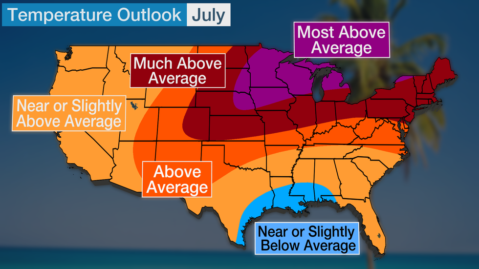
July Temperature Outlook from The Weather Company, an IBM Business.

July is expected to start warmer than average in the Midwest. The second week of the month could be the warmest above average in the Northeast, but warmer than average from the Southern Rockies into the Midwest.

While there will be breaks in the heat, it appears that these breaks will be short-lived, especially in the country’s northern tier.

Why Will It Be So Warm?

Dr. Todd Crawford, The Weather Company’s Chief Meteorologist and the author of the July Outlook, says that the development of a La Niña this summer is the leading cause.

La Niña is a cooling of water temperatures in the Pacific Ocean close to South America that often leads to global changes in temperature and precipitation.

La Niña is both an oceanic phenomenon and an atmospheric one.

Typically, the ocean cools, then the atmosphere responds to the cooling, but this year, the opposite is occurring. In fact, the atmosphere is already acting like a La Niña is occurring, and Crawford expects to see those atmospheric effects continue.
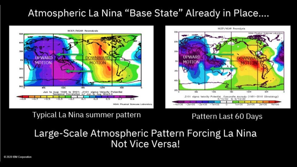
The Atmosphere is already acting like La Niña is occurring

This summer could be significantly warmer than last summer, which saw near to slightly below average temperatures.

"The differences between this summer and last summer are driven by a reversal of the atmospheric forcing in the tropical Pacific. Strong atmospheric suppression (or sinking air) in the eastern tropical Pacific, associated with the developing La Niña event, is resulting in much warmer and drier conditions across the Midwest this year relative to last, ” says Crawford.

In the summer months, La Niña is best known for increasing the chances of a more active hurricane season, but it is also known for warming much of the Lower 48 in July.

A composite of the most recent 10 La Niña Julys shows that above average heat has occurred throughout the northern and central U.S.
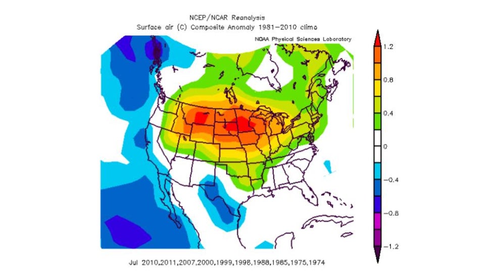
Typical La Nina temperatures in July

The second reason we should expect warmth across the northern tier is a rapid drying of soils over the past 1-3 months. While soils are relatively moist, as of June 27, partially due to Tropical Storm Cristobal’s track up the Mississippi River into the Midwest, the amount of moisture is quickly dwindling under the summer sun.

Drier soils are able to retain heat better than moist soil, especially when the ground becomes dried out and browner. This is similar to a dark car retaining more heat than a light-colored car.
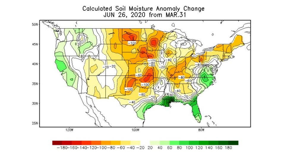
Soil Moisture Changes This Spring

The excessive soil moisture levels, a common feature the last couple of years as El Niño forcing has dominated, have quickly eroded during a very hot and dry June. The continued La Niña forcing should result in a persistence of above-normal temperatures in July in the Midwest, " Crawford explains.

This could become a limited positive feedback loop since more heat would result in drier soils, which would then result in more heating until the cool season arrives.

Typical July Highs

July is the warmest month of the year across much of the country.

This includes a great deal of the central Rockies to the central Plains, upper Midwest, Great Lakes, Ohio Valley and East. Highs typically peak in early to mid-July in most of the Midwest and East while highs peak later, usually in late July or August, in Maine, Florida and in the northern Plains and Rockies.

High temperatures peak in the 80s and 90s across most of the country, while parts of the Pacific Northwest, upper Midwest and border regions of the Northeast reach the 70s for highs.

Parts of the Desert Southwest continue to see highs in the 100s, with highs peaking in early to mid-July.
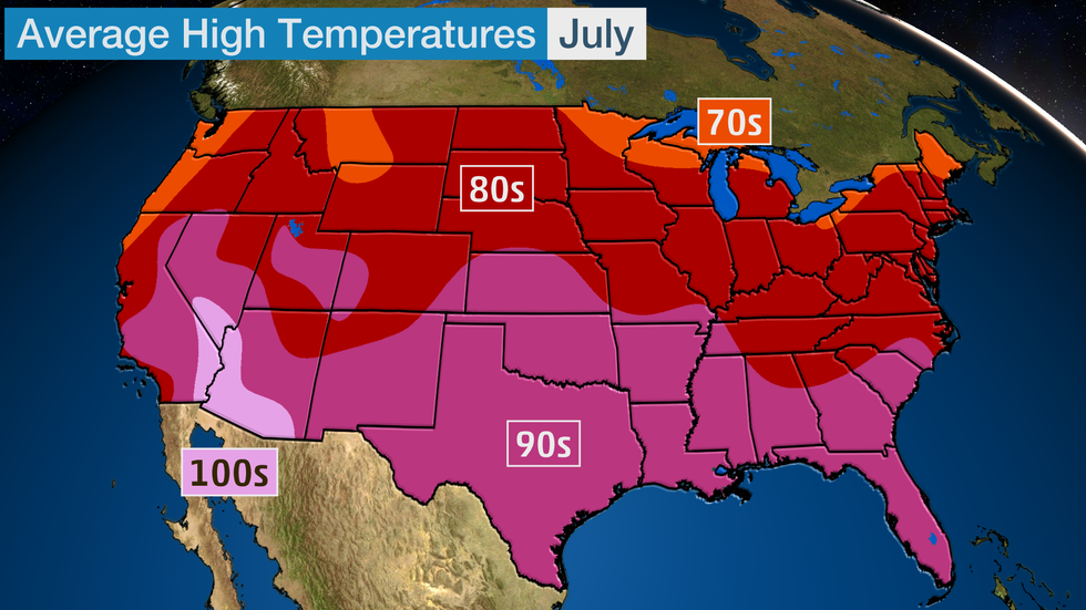
Any heat waves that occur this time of the year could increase these highs by 15-25 degrees.

Average overnight lows are often in the 70s across much of the South and Southwest while the Northeast, Midwest, Plains and West sees lows in the 50s and 60s.

Both warm afternoon highs and overnight low temperatures can be deadly this time of the year. Seek locations with fans or air conditioning and drink plenty of water if you feel warm.

The Weather Company’s primary journalistic mission is to report on breaking weather news, the environment and the importance of science to our lives. This story does not necessarily represent the position of our parent company, IBM.

The Weather Company’s primary journalistic mission is to report on breaking weather news, the environment and the importance of science to our lives. This story does not necessarily represent the position of our parent company, IBM.


This Date in Weather History for July 4,2020

Weather History
For Saturday,July 4 (Independence Day),2020


1776 - Thomas Jefferson paid for his first thermometer, and signed the Declaration of Independence. According to his weather memorandum book, at 2 PM it was cloudy and 76 degrees. (David Ludlum)
1911 - The northeastern U.S. experienced sweltering 100 degree heat. The temperature soared to 105 degrees at Vernon, VT, and North Bridgton ME, and to 106 degrees at Nashua NH, to establish all-time records for those three states. Afternoon highs of 104 at Boston, MA, 104 at Albany, NY, and 103 at Portland, ME, were all-time records for those three cities. (The Weather Channel)
1956 - A world record for the most rain in one minute was set at Unionville, MD, with a downpour of 1.23 inches. (The Weather Channel) (The National Severe Storms Forecast Center)
1987 - Thunderstorms around the country provided extra fireworks for Independence Day. Thunderstorms produced wind gusts to 82 mph at Clearwater, KS, eight inches of rain in four hours at Menno SD, and three inches of rain in just fifteen minutes at Austin, KY. Morning thunderstorms drenched Oneonta AL with 8.6 inches of rain, their greatest 24 hour total in thirty years of records. The heavy rain caused mudslides and serious flooding, claiming two lives. (The National Weather Summary) (Storm Data)
1988 - Thunderstorms produced heavy rain over the Central Gulf Coast Region for the second day in a row. Monroe, LA, was deluged with 3.75 inches in two hours. Aberdeen and Rapid City, SD, reported record high temperatures for the date, with readings of 105 degrees. (The National Weather Summary)
1989 - Independence Day was hot as a firecracker across parts of the country. Nineteen cities, mostly in the north central U.S., reported record high temperatures for the date, including Williston ND with a reading of 107 degrees. In the southwestern U.S., highs of 93 at Alamosa, CO, 114 at Tucson, AZ, and 118 at Phoenix, AZ, equalled all-time records for those locations. (The National Weather Summary) 

This Date in Weather History for July 3,2020

Weather History
For Friday,July 3,2020


1966 - The northeastern U.S. was in the midst of a sweltering heat wave. The temperature at Philadelphia reached 104 degrees. Afternoon highs of 102 degrees at Hartford CT, 105 degrees at Allentown PA, and 107 degrees at LaGuardia Airport in New York City established all-time records for those two locations. (David Ludlum) (The Weather Channel)
1987 - Lightning struck and killed three men playing golf on a course near Kingsport TN. The three men had sought shelter from the rain under a tall tree on a small hill. Showers and thunderstorms produced heavy rain in New Jersey, with 5.2 inches reported at Trenton State College. (The National Weather Summary)
1988 - Thunderstorms around Fort Worth, TX, produced wind gusts to 76 mph at Burleson, along with two inches of rain in thirty minutes. The record low of 46 degrees at Youngstown OH was their sixth in a row. (The National Weather Summary)(Storm Data)
1989 - Showers and thunderstorms produced locally heavy rain in the eastern U.S. Bowling Green, KY, was soaked with 4.99 inches of rain during the morning hours, and up to ten inches of rain deluged Oconee County SC. The temperature at Alamosa, CO, soared to a record warm reading of 91 degrees, following a record low of 35 degrees the previous day. (The National Weather Summary) (Storm Data) 

This Date in Weather History for July 2,2020

Weather History
For Thursday,July 2,2020


1833 - An unusually large New England tornado, one half to three quarters of a mile wide, went from Salem Pond to Norton Pond, VT, and then into Canada. It prostrated nearly everything in its path. (The Weather Channel)
1843 - An alligator reportedly fell from the sky onto Anson Street in Charleston, SC, during a thunderstorm. (David Ludlum)
1987 - Thunderstorms in Colorado produced hail as large as golf balls northwest of Kiowa, which accumulated to a depth of twelve inches. Hail two and a half inches in diameter was reported at Black Forest. Hail damaged 900 acres of crops south of the town of Wiggins. (The National Weather Summary) (Storm Data)
1988 - Twenty-six cities in the eastern U.S. reported record low temperatures for the date. The morning low of 47 degrees at Roanoke, VA, broke the July record set the previous day. (The National Weather Summary)
1989 - Thunderstorms produced severe weather in the south central U.S., with 158 reports of large hail and damaging winds through the day. Evening thunderstorms in northeastern Texas produced softball size hail which caused more than five million dollars damage at Allen, and wind gusts to 90 mph at Dallas, which injured eight persons and caused seven million dollars damage. Winnfield LA reported 29.52 inches of rain in six days, for a total of 62.50 inches for the first six months of the year. Midland, TX, reported an all-time record high of 112 degrees. (Storm Data) (The National Weather Summary) 

This Date in Weather History for July 1,2020

Weather History
For Wednesday,July 1,2020


1792 - A tremendous storm (a tornado or hurricane) hit Philadelphia and New York City. Many young people were drowned while out boating on that Sunday. (David Ludlum)
1911 - The high of just 79 degrees at Phoenix AZ was their coolest daily maximum of record for the month of July. The normal daily high for July 1st is 105 degrees. (The Weather Channel)
1979 - It snowed almost half a foot (5.8 inches) at Stampede Pass WA, a July record. (The Weather Channel)
1987 - Lake Charles LA was drenched with a month's worth of rain during the early morning. More than five inches of rain soaked the city, including 2.68 inches in one hour. A thunderstorm in the southern Yakima Valley of Washington State produced high winds which downed trees up to six feet in diameter. (Storm Data) (The National Weather Summary)
1988 - Twenty-six cities in the north central and northeastern U.S. reported record low temperatures for the date. Lows of 48 degrees at Providence RI, 48 degrees at Roanoke VA, 49 degrees at Stratford CT, and 48 degrees at Wilmington, DE, were records for the month of July. Boston MA equalled their record for July with a low of 50 degrees. Five inches of snow whitened Mount Washington NH. (The National Weather Summary)
1989 - Showers and thunderstorms associated with the low pressure system which was once Tropical Storm Allison continued to drench parts of Mississippi, Louisiana and eastern Texas. Late night thunderstorms produced 12.58 inches of rain at Biloxi, MS, in six hours, and 10.73 inches at Gulfport MS. Flooding in Mississippi over the first six days of the month caused 55 million dollars damage. (The National Weather Summary) (Storm Data) 

This Date in Weather History for June 30,2020

Weather History
For Tuesday,June 30,2020


1886 - The second destructive hurricane in nine days hit the Apalachicola-Tallahassee area. (David Ludlum)
1942 - The temperature at Portland, OR, hit 102 degrees, an all-time record for that location. (The Weather Channel)
1972 - The entire state of Pennsylvania was declared a disaster area as a result of the catastrophic flooding caused by Hurricane Agnes, which claimed 48 lives, and caused 2.1 billion dollars damage. (The Weather Channel)
1987 - Hot weather prevailed in the Pacific Northwest, with readings above 100 degrees reported as far north as southern British Columbia. Yakima, WA, reported a record high of 100 degrees, while temperatures near the Washington coast hovered near 60 degrees all day. Thunderstorms prevailed from southwest Texas to New England. Thunderstorm winds gusting to 100 mph at Gettysburg, PA, killed one person. High winds and large hail caused more than five million dollars damage to property and crops in Lancaster County, PA. (The National Weather Summary) (Storm Data)
1988 - Thunderstorms in eastern Kansas drenched Worden with 12.21 inches of rain, and a wall of water two to four feet deep swept through Lone Star, KS, flooding every home in the town. Up to ten inches of rain was reported southeast of Callaway, NE. Thunderstorm winds gusted to 75 mph at Winfield, KS. Seventeen cities in the north central and northeastern U.S. reported record low temperatures for the date, including Duluth, MN, with a reading of 36 degrees. (The National Weather Summary) (Storm Data)
1989 - Winnfield, LA, reported 22.52 inches of rain in three days, and more than thirty inches for the month, a record for June. Shreveport LA received a record 17.11 inches in June, with a total for the first six months of the year of 45.55 inches. Thunderstorms also helped produce record rainfall totals for the month of June of 13.12 inches at Birmingham AL, 14.66 inches at Oklahoma City, OK, 17.41 inches at Tallahassee FL, 9.97 inches at Lynchburg, VA, and more than 10.25 inches at Pittsburgh, PA. Pittsburgh had also experienced a record wet month of May. (The National Weather Summary) 

This Date in Weather History for June 29,2020

Weather History
For Monday,June 29,2020


1931 - The temperature at Monticello FL hit 109 degrees to establish an all-time record for the state. (The Weather Channel)
1954 - Hurricane Alice dumped as much as 27 inches of rain on the Lower Rio Grande Valley of Texas. The Rio Grande River at Laredo reached a level 12.6 feet above its previous highest mark, and the roadway of the U.S. 90 bridge was thirty feet below the high water. (David Ludlum)
1987 - Thunderstorms produced severe weather in the Ohio Valley and the Great Lakes Region, with reports of large hail and damaging winds most numerous in Ohio, Indiana and Michigan. Thunderstorms spawned four tornadoes in Michigan. A tornado near Clare MI was accompanied by softball size hail. In Colorado, an untimely winter-like storm blanketed Mount Evans with six inches of snow. (The National Weather Summary) (Storm Data)
1988 - Alpena, MI, reported a record low of 39 degrees while Jackson, MS, equalled their record for the month of June with an afternoon high of 105 degrees. Thunderstorms in the central U.S. soaked Springfield MO with 3.62 inches of rain, a record for the date. (The National Weather Summary)
1989 - Thunderstorms produced severe weather in the Southern and Central High Plains Region. Thunderstorms in Colorado produced softball size hail at Kit Carson, while pea to marble size hail caused ten million dollars damage to crops in Philips County, CO. (The National Weather Summary) (Storm Data) 

Man missing at sea for nearly 2 weeks found alive in life raft off Washington coast

  One of two men missing at sea for nearly two weeks was found alive on Thursday by a Canadian fishing boat in a life raft in Canadian water...