Jan Wesner Childs and Sean Breslin
One day after Hurricane Otis made landfall, the resort city of Acapulco has descended into chaos.
Desperate residents have been left with no electricity or internet and communications are difficult if not impossible as rivers of mud still cover city streets, the Associated Press reports. Shattered buildings show the destructive power of Otis, which roared ashore early Wednesday as a dangerous Category 5 hurricane.
Jakob Sauczuk was staying with a group of friends at a beachfront hotel when Otis hit. “We laid down on the floor, and some between beds,” Sauczuk said. “We prayed a lot.”
One of his friends showed reporters photos of the windowless, shattered rooms in the hotel. It looked as if someone had put clothes, beds and furniture in a blender, leaving a shredded mass.
Sauczuk complained that his group was given no warning, nor were offered safer shelter, by the hotel.
Pablo Navarro, an auto parts worker who was lodged in temporary accommodations at a beach front hotel, thought he might die in his 13th story hotel room.
“I took shelter in the bathroom, and thankfully the door held,” said Navarro. “But there were some room where the wind blew out the windows and the doors.”
Official information has been slow to come. As of early Thursday, there was no word on early damage estimates or whether anyone was injured or killed.
Otis underwent explosive rapid intensification, jumping from a tropical storm on Tuesday morning to a Category 5 hurricane when it made landfall.
Here are our earlier live updates:
(4:21 p.m. ET) Acapulco Streets Covered In Water
Video shared on social media shows deep, muddy water flooding streets in Acapulco. There's still no official word on conditions there.
(4:10 p.m. ET) Mudslides And Flooding Are The Next Big Concerns
From digital meteorologist Jonathan Belles: While much of the attention so far has been rightfully placed on the extreme wind speeds near Acapulco, water will rapidly take over as a bigger concern through the rest of the week.
Hurricanes moving into some mountainous parts of Mexico are like throwing water balloons at somebody. The balloon disappears, but the water all has to go somewhere. Mudslides and flooding due to runoff should be expected anywhere, but especially here where a foot or more of rain may pile up before the area dries out. This water could be just as damaging and potentially more deadly than the winds near the coast.
(3:15 p.m. ET) Desperate Residents Climb Out Of Storm Debris
Dozens of families, women and children climbed over tree trunks and traversed mud and other debris from landslides after being trapped by the storm.
“We had been waiting since 3 in the morning to get out, so we decided to walk," Flor Campos, who lives in a small town impacted by Otis, told The Associated Press. "It was more dangerous to stay. There are trees knocked down, power lines down.”
Campos walked through mud along a highway for at least an hour, finally taking off her shoes for fear they'd be lost in the muck.
(3:08 p.m. ET) Otis Weakens But Still Packs A Punch
From meteorologist Ari Sarsalari: After quickly losing strength over mountainous terrain, Otis is now a tropical storm, and although the wind has lost a lot of strength, the storm is still dropping very heavy rain which will likely lead to additional flooding and landslides in southwestern Mexico
(2:58 p.m. ET) More Photos Emerge Of Damage In Mexico
Click through our slideshow below to see what it looks like in parts of Mexico hit by Otis. Be sure to check back as we add new images.
(2:14 p.m. ET) Why Was Otis So Hard To Forecast?
From senior meteorologist Jonathan Erdman: The storm's incredible rapid intensification happened less than 24 hours before landfall as a Category 5 hurricane near Acapulco. That put it among the most prolific rapid intensification events on record worldwide. While watches and warnings were issued on Monday and Tuesday, computer model and National Hurricane Center forecasts severely underestimated its intensity.
Hurricane intensity forecasts have improved over the years. But there are still a few cases of explosive intensification that forecast models can have difficulty with.
Since hurricanes feed off deep warm water and moist air, they have a better chance of growing stronger and intensifying more rapidly in a warming world. That's disconcerting, given the pockets of shallow, warm water that can exist near coastlines in the hurricane zone, which was the situation with Otis.
And that remains a significant challenge for scientists developing more sophisticated computer models to accurately forecast the next such event with as much warning as possible.
More: Hurricane Otis 'Nightmare Scenario' Explained
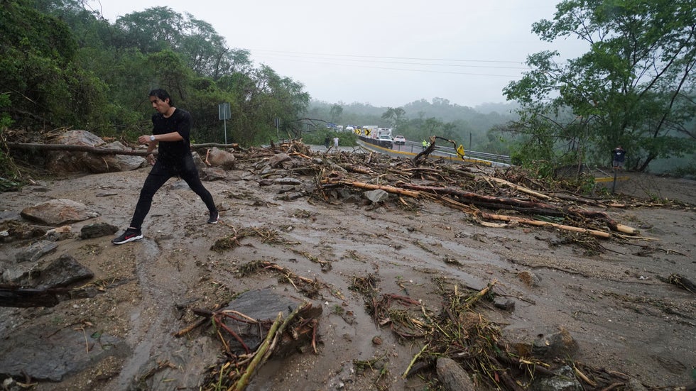
 A man crosses a highway blocked by a landslide triggered by Hurricane Otis near Acapulco, Mexico, Wednesday, Oct. 25, 2023.
(1:29 p.m. ET) Photos Show Damage In Acapulco's Tourist District
Some of the first photos out of Acapulco show roof damage and debris strewn around some buildings. The caption reads: "The mobile phone signal returned for minutes and this is the image of the Costera Miguel Aleman after the passage of the hurricane Otis in Acapulco, Guerrero."
Costera Miguel Aleman is a main road in the tourist district.
(1:14 p.m. ET) Earthquake Warning System Knocked Out
SkyAlert, an earthquake warning app used across Mexico, said much of its seismic sensor network was knocked offline by Otis.
"This situation means that, should an earthquake occur in these areas, we will not be able to alert the population," the company said in a news release.
The towns most affected include: San Marcos, Ayutla, Cuajinicuilapa, Acapulco, Coyuca de Benitez, Atoyac de Alvarez, San Jeronimo, Tecpan, Petatlan and Ixtapa-Zihuatanejo.
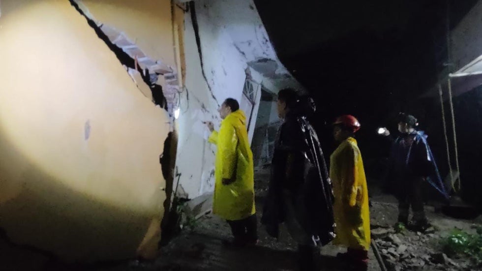
 Officials inspect damage from Hurricane Otis in Chilpancingo, Mexico, on Wednesday, Oct. 25, 2023.
(12:40 p.m. ET) Landslides Blocking Major Highway
Photos posted to social media show debris including dirt, rocks and tree branches blocking a roadway between Acapulco and Chilpancingo, about 60 miles to the northeast.
(12:16 p.m. ET) The Connection Between Rapid Intensification And Climate Change
Hurricane Otis is just the latest storm to undergo rapid intensification.
And while a number of factors are at play when storms do this, science tells us one of them is climate change. Greenhouse gas emissions are pushing more heat in our atmosphere, much of which is absorbed by the world’s oceans.
Warm water is the key fuel for hurricanes. Sea surface temperatures in the Pacific around Acapulco are well into the 80s right now, which is higher than average.
The latest research on the connection between climate change and rapid intensification shows that this type of explosive growth in storms is now twice as likely to happen as it was 30 years ago.
More: How A Warmer World Affects Hurricanes
(11:38 a.m. ET) Travelers Should Reconsider Trips To Affected Areas
From travel editor Nicole Bonaccorso: Ángeles Verdes, Mexico’s general directorate of tourist services, advised people to reconsider traveling to areas heavily impacted by Otis, The Independent reported. He also urged travelers to remain informed about the situation in southwestern Mexico.
Several flights to and from General Juan N. Alvarez International Airport in Acapulco were canceled Wednesday, according to airline tracker FlightAware.com.
More: Should You Cancel Your Mexico Vacation?
(10:19 a.m. ET) All Communications Cut Off With Affected Areas
"Until now we have no data on loss of human life, but there is no communication, we do not know," Mexico President Andres Manuel Lopez Obrador said in a morning news conference, according to local media.
(9:58 a.m. ET) No Official Word On Damage
It's now daylight in Acapulco, and officials and residents alike are likely getting their first look at the damage. Much of the area remains without power. There are reports of downed trees, rain and ongoing flooding.
(8:45 a.m. ET) New Footage Shows Trees Being Thrashed By Powerful Winds
As Hurricane Otis made landfall, it brought powerful, damaging winds. As is typically seen with major hurricane landfalls, images and video are slow to emerge from the area due to myriad reasons like power outages and residents sheltering from the worst of the tropical cyclone, but new footage from overnight shows the winds battering palm trees in Acapulco. Watch the video here.
(7:45 a.m. ET) Damage Seen At Acapulco Hotel
At the Copacabana Beach Hotel in Acapulco, images shared to social media prior to sunrise showed a faint view of serious damage to structures, as well as street flooding.
Damage was also seen elsewhere in the city.
(7:30 a.m. ET) First Look (And Listen) At The Powerful Winds
Video is starting to come in from Acapulco, which is being battered by Hurricane Otis after a 165 mph Category 5 landfall. This video shows just how loud and powerful the storm's wind gusts were as they struck the Mexican city.
(6:40 a.m. ET) Watch Otis Make Landfall As A Category 5 Hurricane
Otis made landfall at about 1:25 a.m. CDT Wednesday with maximum sustained winds of 165 mph near Acapulco, and CIRA captured the historic occurrence on satellite
(6:20 a.m. ET) Otis's Landfall A 'Nightmare Scenario'
Forecasters with the National Hurricane Center warned that in addition to the incredibly rapid intensification of Otis just hours before landfall, which provided little time for a city of 850,000 to prepare, the hurricane was also striking an area that hadn't seen a storm of this strength in modern record.
"There are no hurricanes on record even close to this intensity for this part of Mexico," said the NHC.
Much of the forecast modeling suggested Otis would not strengthen into a major hurricane, if a hurricane at all, giving little indication that a Category 5 monster was on the horizon. Read this as we more closely examine three factors that might have contributed to this storm's rapid intensification.
(6 a.m. ET) Acapulco Battered By Life-Threatening Storm Surge, Destructive Winds
Otis is bringing life-threatening storm surge flooding to southwestern Mexico, as well as the threat of flash flooding and mudslides in higher terrain. The National Weather Service warned that the storm could cause catastrophic damage.
Videos showed powerful winds as the storm lashed Acapulco, knocking out power to much of the city.
There were reports of major damage to a hotel in Acapulco from the storm's strong winds.
(5:30 a.m. ET) Evacuations Rushed Prior To Landfall
President Andrés Manuel López Obrador urged residents in threatened areas to move to shelters ahead of the storm.
"Agree to move to shelters, stay in safe places: away from rivers, streams, ravines, and be alert,” he said on Tuesday on X.
Mexico’s National Coordination of Civil Protection evacuated residents in dangerous areas to temporary shelters in Acapulco and Tecpán de Galeana and recommended that Acapulco residents take shelter as the storm approached.
The Weather Company’s primary journalistic mission is to report on breaking weather news, the environment and the importance of science to our lives. This story does not necessarily represent the position of our parent company, IBM.
The Weather Company’s primary journalistic mission is to report on breaking weather news, the environment and the importance of science to our lives. This story does not necessarily represent the position of our parent company, IBM.

No comments:
Post a Comment