weather.com meteorologists
Hurricane Lee is on the move north through the western Atlantic and its large size means it will spread strong winds, rain and coastal flooding far from its center to eastern New England and Atlantic Canada by this weekend.
Lee is also producing rip currents and high surf along much of the East Coast, providing another example of how hurricanes can be a danger for beachgoers far away from where a storm is tracking.
What's the latest on Lee? Lee is a large hurricane centered several hundred miles south of Nantucket, Massachusetts, and is moving to the north.
 Enhanced Satellite
Lee is now a Category 1, but that's not as much of an attention-grabber as its size.
Hurricane-force winds extend outward up to 105 miles from the center and tropical-storm-force winds extend out up to 345 miles. That's a large wind field for a hurricane. A 52 mph wind gust was recently reported in Bermuda.
(MAP TRACKER: Spaghetti Models And More)

Here's are the latest watches and warnings for Lee: A hurricane watch has been issued from Stonington, Maine, to Point Lepreau, New Brunswick, and also from Digby to Medway Harbour, Nova Scotia, including Yarmouth. That means hurricane conditions are possible in these areas within 48 hours.
A tropical storm warning has been issued for the coast of Massachusetts from Westport, Massachusetts northward to the Canadian border, including Cape Cod, Martha's Vineyard, and Nantucket. A tropical storm warning is also in effect for Bermuda.
In Canada, a tropical storm watch is in effect from Point Lepreau to Fort Lawrence, New Brunswick, as well as over much of Nova Scotia, including Halifax. That means tropical storm conditions are possible in these areas within 48 hours.

Here's where Lee will go the next few days: Lee is now en route toward the Gulf of Maine, or the waters near eastern New England and western Atlantic Canada, and will arrive by Saturday.
Lee's peak winds are expected to continue stepping down. That's because it will encounter cooler water, partly induced by upwelling from Hurricane Franklin and the remnants of Idalia, drier air, higher wind shear and eventually will also pass north of the warm Gulf Stream into even cooler water.
Even though the hurricane will weaken, its wind field will be very large, which means impacts will extend far outside the forecast path shown below.
(MORE: 12 Things You May Not Know About Hurricane Forecasts)
 Current Status And Forecast Path
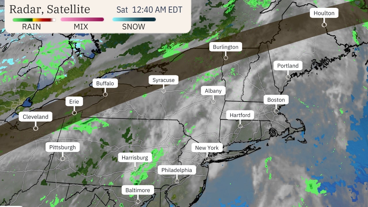
Here's a look at potential impacts in New England: Wind, rain and coastal flood impacts will arrive by late Friday and especially Saturday, but the extent of those impacts will be determined by the exact path of Lee.
The forecast track for Lee has shifted a bit east over the past day or so, which means its strongest winds and heaviest rain could be confined from immediate coastal areas of Massachusetts and New Hampshire to Maine.
Here's a look at what we know right now.
Wind Threat
Tropical-storm-force wind gusts (39 mph or greater) are possible in far eastern New England.
There is the possibility that Lee's winds in combination with saturated soils could down trees and knock out power in some areas, especially in far eastern New England.
(MORE: Lee Interactive Tracker)
Storm Surge Threat
Coastal flooding and large, pounding surf are also likely impacts from coastal Massachusetts to Maine.
Storm surge of 1 to 3 feet is possible along much of the New England coast and along Long Island.

Rainfall Flooding Potential
Lee could produce rainfall amounts of 1 to 4 inches in far eastern New England.
The region has been soaked over the past week, so any heavier rainfall could cause localized flooding.
(MORE: Will Lee Add To Already Flood-Weary New England?)

Here's what to expect in Atlantic Canada: Much like eastern New England, Nova Scotia and New Brunswick will likely see heavy rain, strong winds, high surf and coastal flooding develop by Friday night or Saturday and continue into Saturday night or early Sunday.
Interests in all of the above-mentioned locations should continue to monitor Lee's forecast closely.
Dangerous surf, rip currents will occur along most of the East Coast: Swells generated by Lee are already affecting a large part of the East Coast. That means high surf, rip currents, coastal flooding and even beach erosion could occur along parts of the coast.
Keep this in mind if you live near or plan to head to the Atlantic beaches this week. Stay out of the water, especially if red flags are flying at the beach.
(MORE: Lee An Example Of How Atlantic Hurricanes Can Produce Deadly Rip Currents)
Lee's History So Far
Lee became the 13th storm of the 2023 Atlantic hurricane season last Tuesday afternoon and the fourth hurricane of the season last Wednesday afternoon. That was over a week ahead of the average fourth hurricane pace of Sept. 16, according to National Hurricane Center data.

Lee then underwent explosive rapid intensification, going from a Category 1 to a Category 5 hurricane in just 18 hours last Thursday. Only three other Atlantic hurricanes since 1982 had seen their winds increase by 80 mph in 24 hours or less since 1982, most recently Matthew in 2016. It was the fastest 24-hour intensification anywhere in the Atlantic Basin outside the Gulf of Mexico and Caribbean Sea in 41 years, according to Kieran Bhatia, a Princeton University scientist.
Sustained winds of 160 mph were recorded by hurricane reconnaissance last Thursday evening, making it the first Category 5 hurricane since Ian in 2022. Prior to Lee, only 39 other Atlantic hurricanes have reached Category 5 intensity over the past 100 years.
Lee quickly weakened to a Category 2 on Saturday because of increased wind shear. It then gained strength again late Sunday and returned to Category 3 intensity.
The Weather Company’s primary journalistic mission is to report on breaking weather news, the environment and the importance of science to our lives. This story does not necessarily represent the position of our parent company, IBM.
The Weather Company’s primary journalistic mission is to report on breaking weather news, the environment and the importance of science to our lives. This story does not necessarily represent the position of our parent company, IBM.


No comments:
Post a Comment