Chris Dolce
Fall's official start on Saturday, Sept. 23, marks the beginning of a season where the atmosphere battles it out between summer's leftovers and Old Man Winter trying to nudge its way into the picture.
First freezes and first snows of the season often arrive in fall. But hurricane season can remain active, and severe weather, including tornadoes, can be a concern at times. The West is also introduced to multiple changes.
Here are five things we typically watch for as the new season unfolds.
1. First freeze of the season arrives for many: The first 32-degree low temperatures are usually experienced prior to or right around the time fall officially begins in the higher elevations of the West and near the Canadian border.
By the end of October, the first freeze on average has occurred from much of the Northeast into the Midwest and even northern parts of the South. First freezes are common in November from the coastal mid-Atlantic into much of the Deep South.
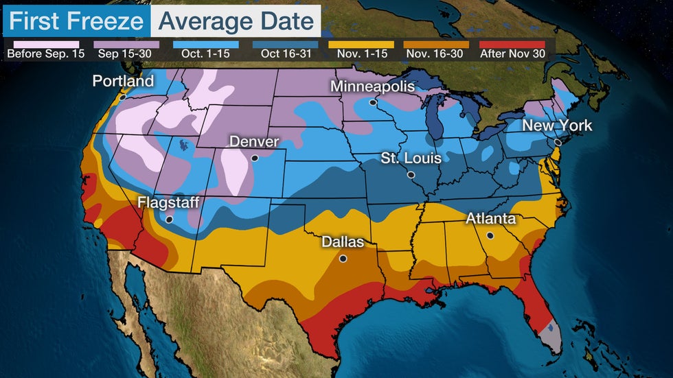 Average time of first freeze.
2. First measurable snow arrives for many: The higher elevations of the mountains in the West are most likely to see snow by the end of September, if not earlier.
By October, areas from the higher elevations of the West into the Northern Plains, northern Michigan and northern new England typically see the first measurable snow, defined as at least one-tenth of an inch.
An even larger portion of the country experiences its first measurable snowfall by the end of November or early December, including from the Northeast into the Midwest and Southern Rockies.
(MORE: Deeper Dive On When To Expect The First Snow)
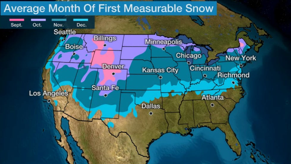 Month of the average first accumulating (0.1 inches or greater) snowfall of the season, according to 30-year average statistics.
3. Hurricane season can still be active, but its end is in sight: Atlantic hurricane season is still in full swing as fall begins.
Four additional named storms typically develop in the Atlantic after the fall equinox, based on the 1991-2020 average.
Since 2016, we've seen hurricanes Matthew, Nate, Michael, Delta and Zeta all make a U.S. landfall in October.
Last year, Hurricane Nicole made landfall in Florida on Nov. 10. Nicole was just the fourth November hurricane to landfall in the mainland U.S. in records dating to the mid-19th century, the first to do so since Hurricane Kate struck the Panhandle in 1985.
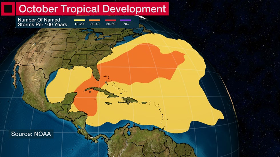
Fall is also when the area we watch for tropical development in the Atlantic typically begins to contract in size.
By October, we usually see the formation zones of tropical storms and hurricanes shift westward toward parts of the Caribbean Sea, Gulf of Mexico and far western Atlantic Ocean as the "Cabo Verde" portion of the hurricane season – with development of African easterly waves in the eastern Atlantic Ocean – fades.
Nov. 30 is the official end of the hurricane season, but there have been rare Atlantic storms after that date.
4. Severe weather and tornado outbreaks are possible: Just like spring, fall is a battleground season where warm, humid air from the Gulf of Mexico meets up with the increasingly stronger cold fronts and jet stream winds that typically sweep across the country.
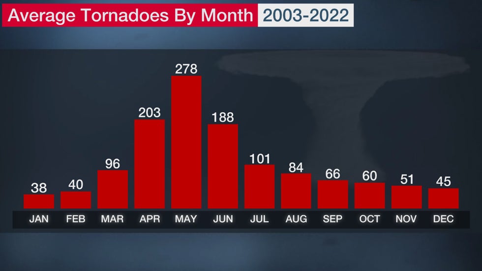
When this mix of ingredients comes together, it can ignite numerous severe thunderstorms that produce damaging winds, large hail and tornadoes. That said, fall's average number of tornadoes are still nowhere near the levels we see in spring.
November 2022 was a reminder of how active fall can be with an above-average 68 tornadoes in the month, most of which were in the South. Deadly tornadoes struck Texas and Oklahoma on Nov. 4, and then Alabama early on Nov. 30.
One of the nation's worst tornado outbreaks happened just days before Thanksgiving 1992 when a swarm of 105 tornadoes tore through parts of 13 states from Texas to the Carolinas. The severe weather claimed 26 lives and injured another 638.
(MORE: Recent Years Show Tornadoes Are A Danger In Fall, Winter)
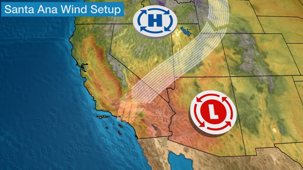
5. Two changes to watch for in the West: One weather pattern that emerges in the fall features a strong area of high pressure over the interior West, which results in offshore winds, including Santa Ana winds, from the northeast or east moving through canyons and passes in Southern California. These winds can also create hot temperatures.
Santa Ana winds are most common from September through March and can add to the fire danger when combined with low humidity or ongoing fires. Wildfire danger is usually highest in the fall due to the drier vegetation as California ends its dry season.
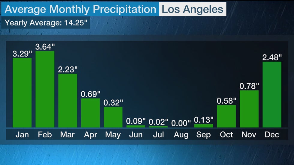
The second thing that usually happens as we head deeper into fall is the jet stream begins to drive low-pressure systems farther south than in the summer, increasing precipitation in the West.
This includes Los Angeles, which sees its average rainfall notably increase beginning in November.
In the Pacific Northwest, precipitation amounts begin to increase in October. That's followed by November, which is one of the three wettest months of the year, on average, in Seattle and Portland, Oregon, with 5.85 inches and 5.45 inches, respectively.
The Weather Company’s primary journalistic mission is to report on breaking weather news, the environment and the importance of science to our lives. This story does not necessarily represent the position of our parent company, IBM.
The Weather Company’s primary journalistic mission is to report on breaking weather news, the environment and the importance of science to our lives. This story does not necessarily represent the position of our parent company, IBM.

No comments:
Post a Comment