Jan Wesner Childs
The giant double-bin debris trucks no longer rumble through the streets of Fort Myers Beach every day.
Instead, chainsaws buzz and pile drivers bang.
"Every day you hear something new, you hear new sounds and it just means that there's progress happening," Mayor Dan Allers said Tuesday.
Albeit slowly.
(MORE: Hurricane Ian - Lessons Learned One Year Later)
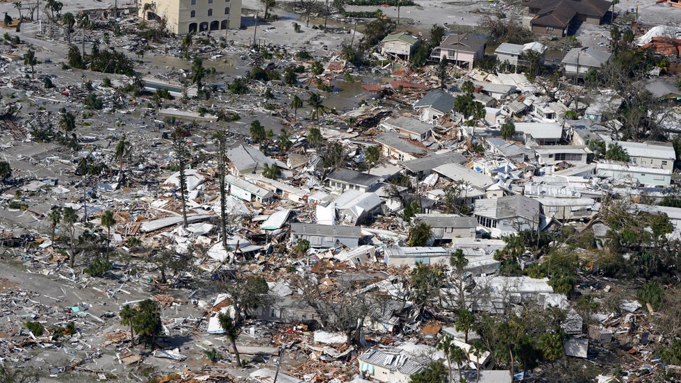
Hurricane Ian roared ashore a year ago in Southwest Florida with winds gusting up to 140 mph and storm surge that rose as high as 15 feet. The Lee County barrier island communities of Fort Myers Beach and Sanibel were devastated.
“Most people lost everything that they've accumulated their entire lives in a matter of hours,” Allers said.
The state’s official death toll counts 151 fatalities connected to the storm. Nearly half happened in Lee County.
“This week, it’s a tough week for a lot of people,” Sanibel city councilwoman Holly Smith said Wednesday.
Residents Struggle To Rebuild
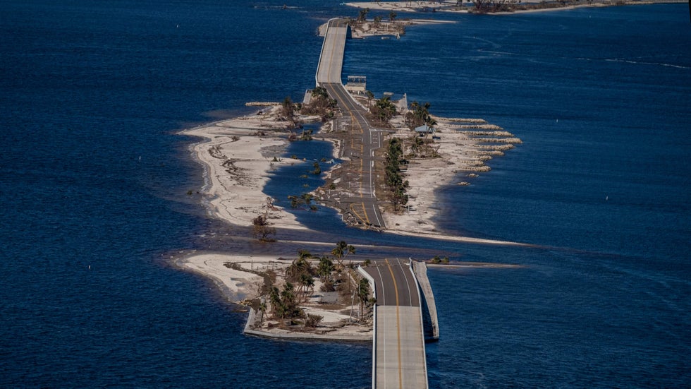
The broken hull of the causeway connecting Sanibel to the mainland was one of the most enduring images of Ian's wrath. Now, contractors and construction vehicles create morning traffic jams on the repaired bridge.
 An aerial picture taken on September 30, 2022 shows the collapsed Sanibel Causeway in the aftermath of Hurricane Ian in Sanibel, Florida.
Smith was mayor when Ian hit. She and her husband and two dogs camped out in their heavily damaged home with no electricity for a time after the storm. Rebuilding on it started seven weeks ago.
Allers recently moved back into his repaired home after living in a trailer in his front yard for most of the past year.
But for others, that day may never come. Smith estimates that only about 1,000 of Sanibel’s 6,700 year-round residents are currently living there.
Many, she said, are fighting with their insurance companies or they weren’t insured for enough money to cover the cost of rebuilding. Experts say it’s the latest sign of trouble in Florida’s beleaguered insurance industry.
(MORE: Why Aren't All Beach Houses Built On Stilts?)
Homes built in the 1960s and 70s when much of coastal Florida was developed cost much more to rebuild after a storm. That’s because of FEMA rebuilding rules and stricter building codes intended to make homes more resilient, the cost of labor and supplies and other issues.
“Some had put their entire life savings to live here on the island and they can no longer live here so they have to sell their property and move on,” Allers said.
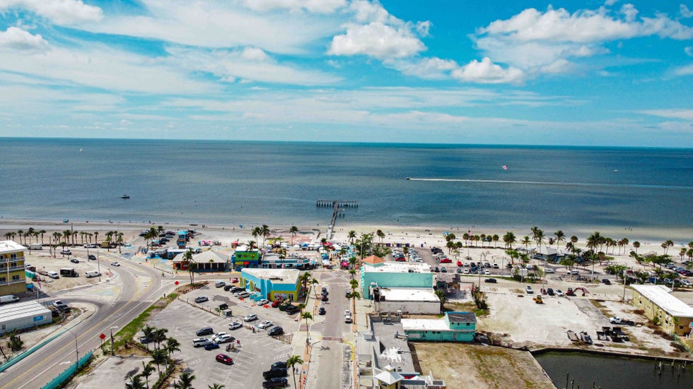 An aerial view of Fort Myers Beach, Florida, on Sept. 23, 2023.
Empty Lots, Damaged Homes For Sale
There are 131 empty lots listed for sale in Fort Myers Beach and 53 in Sanibel. Many show barren sand or empty slabs where a building once stood. At the low end is the asking price of $80,000 for a 4,835-square-foot lot in a manufactured home community called Bayside Estates that was decimated by the storm.
At the upper end is a $15 million commercial property that used to be home to a general store destroyed by the storm.
The least expensive single family home on the market in Fort Myers Beach is pending sale at a list price of $635,000, according to realtor.com. It’s got two bedrooms, one and a half bathrooms and visible hurricane damage.
The list price is $165,000 more than the home previously sold for in 2019, according to Lee County property records.
(MORE: Here's How A Warmer World Could Affect Hurricane Season)
Middle class families and those on fixed incomes have been getting priced out of towns like these for decades. But Smith worries Ian could change the face of her community forever.
“That's a real concern for our city moving forward because people have this thought that Sanibel is made up of a very elite buyer resident. But really, that's a small fraction of what we are here on this island,” she said.
“Many of our owners have been generational owners, elderly, young families coming in that could afford it a few years ago.”
It’s a problem expected to get worse as weather becomes more extreme and brings more catastrophic damage.
“That's going to be part of a broader demographic shift, particularly for retirees and people on fixed income, that simply won't be able to entertain recovery from these shocks time and time again and they simply won't be able to afford it,” Jesse Keenan, a Tulane University expert in real estate and climate, said in a previous interview.
(MORE: Climate Change Generating Strong Hurricanes Earlier, Study Shows)
The number of billion-dollar disasters has risen steadily in the U.S. since the 1980s, and this year is on track to break a record.
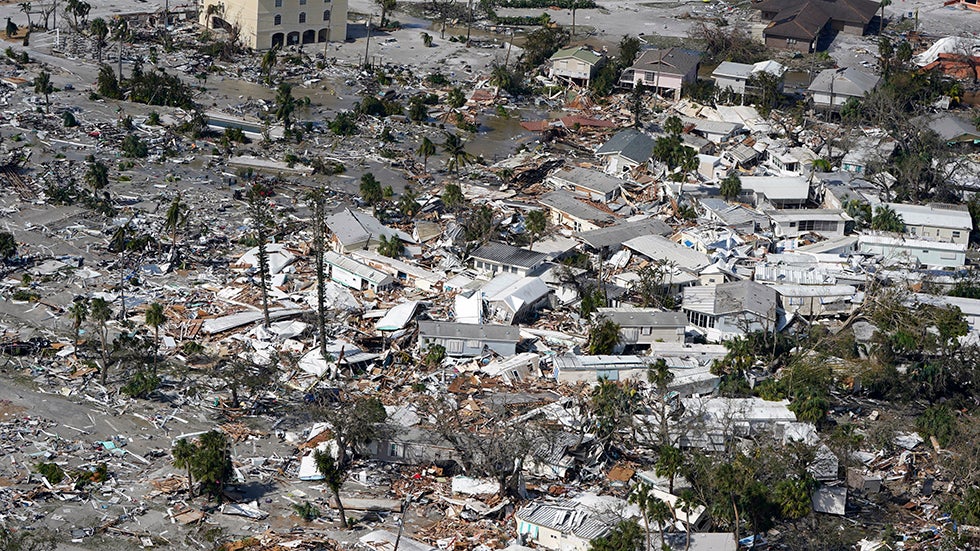 Damaged homes and debris are shown in the aftermath of Hurricane Ian, Thursday, Sept. 29, 2022, in Fort Myers, Fla.
Crossing Their Fingers For This Hurricane Season
In August, Hurricane Idalia skirted up Florida’s Gulf Coast past Lee County on its way to landfall further north.
“I can tell you the PTSD that was felt around this island,” Smith said.
Idalia brought some high tides to the area, but no major damage.
“We are getting through our hurricane season and we are just crossing our fingers that we are spared for a very long time,” Smith said. “Because we have so far to go in our recovery and if we are hit by a hurricane, minimal or major, it's going to have a very severe emotional toll on us.”
Weather.com reporter Jan Childs covers breaking news and features related to weather, space, climate change, the environment and everything in between.
The Weather Company’s primary journalistic mission is to report on breaking weather news, the environment and the importance of science to our lives. This story does not necessarily represent the position of our parent company, IBM.
The Weather Company’s primary journalistic mission is to report on breaking weather news, the environment and the importance of science to our lives. This story does not necessarily represent the position of our parent company, IBM.