Jonathan Erdman and Jan Wesner Childs
Hurricane Ian dealt a devastating blow to southwest and central Florida in late September 2022.
The storm was one of America's deadliest hurricanes since 1980. It was also America's third costliest hurricane on record ($115 billion estimated damage) and the costliest in Florida history.
Here are some key takeaways - and things we’ll never forget - about this historic hurricane.
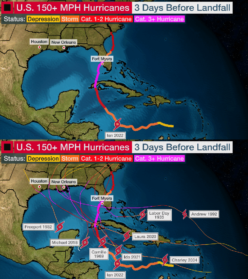
Only three days before landfall, Ian was a tropical storm. Only three days before its catastrophic Category 4 landfall, Ian was a tropical storm in the southern Caribbean Sea.
That put the storm in alarming company. The strongest hurricanes to hit the U.S. with winds of 150 mph or stronger in the last century were all still tropical storms three days before landfall, as noted by former National Hurricane Center director Ken Graham.
Among these notorious hurricanes were all four Category 5 mainland U.S. landfalls: Michael (2018), Andrew (1992), Camille (1969) and the Labor Day Hurricane (1935).
This is one reason why it's important to have your hurricane plan ready to go before a storm threatens.
 Track of Hurricane Ian in 2022, and other hurricanes that made 150-plus mph mainland U.S. landfalls over the past 100 years. Each of those 9 hurricanes were tropical storms just three days prior to landfall.
Hurricane forecasts can and do change. In Ian's case, initial track forecasts targeted southwest Florida. But computer forecast guidance shifted north toward Florida's Big Bend, then trended back south, finally curling south from Tampa Bay toward southwest Florida.
That can happen when there's uncertainty in the storm's steering winds, which can make a big difference in where it ultimately goes.
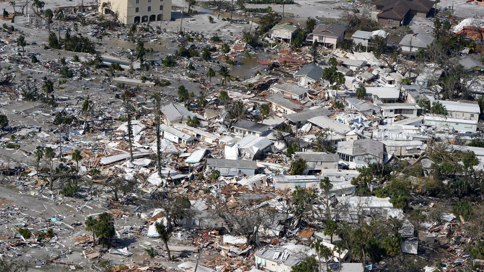
When a hurricane like Ian is moving roughly parallel to a heavily populated coast, that means the difference can be huge between some rain, wind and a blowout tide, like what happened in Tampa Bay, and the devastating one-two punch of surge and eyewall winds that destroyed Fort Myers Beach and nearby areas.
Check often for potential forecast changes during the duration of a tropical storm or hurricane threat.
You should evacuate when ordered to do so. Ian's storm surge reached 10 to 15 feet above ground in Fort Myers Beach and Estero Island and claimed 41 lives, according to the National Hurricane Center's final report.
The state of Florida’s final death toll includes several people who died because of medical needs or other reasons that were exacerbated by not evacuating.
Water marks were found on the second floors of some buildings. One couple had to cut a hole in the ceiling of their business to escape the floodwater. Time-lapse video noted in the NHC report showed a home that "floated off its foundation with large waves crashing over it."
If you have nowhere else to go or can't evacuate, local officials can help. Many counties and states, including Florida, have a special needs registry for people who would need assistance evacuating, during a power outage or in other emergencies.
 Damaged homes and debris are shown in the aftermath of Hurricane Ian, Thursday, Sept. 29, 2022, in Fort Myers Beach, Fla.
Every hurricane is different. Despite making its Florida landfall in exactly the same location (near Cayo Costa, Florida) and with the same peak wind speed (150 mph) as 2004's Hurricane Charley, Ian was a much different storm in several key respects.
Ian was much larger than tiny Charley. That led to a much higher storm surge in Ian (up to 15 feet) than Charley (up to 7 feet). Ian also moved much slower than the buzzsaw that was Charley. That prolonged the impacts in Florida and produced much heavier rain totals in Ian.
A hurricane with a similar track, intensity or landfall forecast to a previous hurricane may not necessarily yield the same impacts.
Hurricanes don't stop at the coast. Ian produced wind gusts over 70 mph across central and northeast Florida. But perhaps the most notable inland impact was the epic rainfall flooding.
Ian wrung out up to 27 inches of rain over a strip of the Florida Peninsula. That triggered record flooding that lasted for weeks along stretches of waterways including the Peace and St. Johns rivers.
Ian also smashed Orlando's 24-hour rainfall record (12.49 inches), leading to "unprecedented flooding" in Osceola County.
The state’s death count lists fatalities connected to Ian in 19 different counties, from Monroe in the Florida Keys to Putnam 350 miles north.
It was yet another close call for Tampa-St. Petersburg. The forecast path of Ian, for a time, was centered near the Tampa-St. Petersburg metro area before it made its final curl south toward Fort Myers Beach.
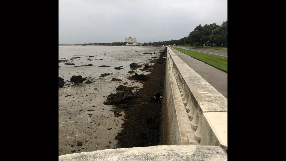
Ian did produce wind gusts up to 77 mph in the Tampa Bay area. But, because of its track well south, it pushed water out of the bay instead of piling it in, as also happened five years earlier in Hurricane Irma.
It was just the latest near miss for an area that is extremely vulnerable to surge from a major hurricane.
On Oct. 25, 1921, a Category 3 hurricane made landfall near Tarpon Springs, Florida, producing storm surge of up to 11 feet in Tampa Bay, which caused extensive damage. At the time, the metro area had a population of less than 150,000. Today, that population is estimated at 3.3 million.
 The water is seen receded from Hillsborough Bay in Tampa, Fla., in what is considered a “blowout tide” on Wednesday, Sept. 28, 2022, as Hurricane Ian approaches.
MORE ON WEATHER.COM
-Where The 2023 Atlantic Hurricane Season Stands
-Seven Things Florida Newcomers Should Know About Hurricane Season
-Why Aren't All Beach Houses Built On Stilts?
-Here's How A Warmer World Could Affect Hurricane Season
Weather.com reporter Jan Childs covers breaking news and features related to weather, space, climate change, the environment and everything in between.
Jonathan Erdman is a senior meteorologist at weather.com and has been covering national and international weather since 1996. His lifelong love of meteorology began with a close encounter from a tornado as a child in Wisconsin. Reach out to him on X/Twitter, Facebook and Threads.
The Weather Company’s primary journalistic mission is to report on breaking weather news, the environment and the importance of science to our lives. This story does not necessarily represent the position of our parent company, IBM.
The Weather Company’s primary journalistic mission is to report on breaking weather news, the environment and the importance of science to our lives. This story does not necessarily represent the position of our parent company, IBM.

No comments:
Post a Comment