Chris Dolce
A weather pattern called an "omega block" that's setting up in western Canada will keep parts of the northern U.S. feeling comfortable by August standards as a heat dome continues to bake Texas and the Southwest.
Here's what the omega block means: An area of high pressure in the upper atmosphere will be parked over western Canada this weekend into early next week. Southward plunges of the jet stream will exist on both sides of that high, including one dipping south across much of the northern U.S.
Now, notice how the jet stream pattern – that ribbon of fast-flowing air some 30,000 feet above the ground – described above and depicted in the image below resembles the greek letter omega: Ω.
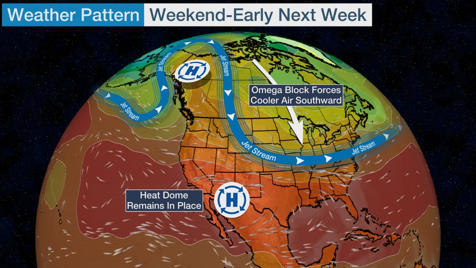
The term "omega block" is not new (we've talked about it before earlier this year) and is often taught in basic meteorology courses. It's one of multiple blocking patterns that meteorologists learn about, and all of them feature an exaggerated north-to-south jet stream alignment that causes weather patterns to move slowly for a time.
Here's what this omega block means for your temperatures: As you can see below, areas from the northern Rockies into the Midwest and Northeast will generally see highs that are near or below average for early August this weekend into early next week. That's because the blocking high in western Canada will help to force relatively cool air by August standards from northern latitudes southward into those regions.
But this pattern shift won't eradicate the heat dome that's been searing parts of the southern U.S. since July. Areas from the Desert Southwest into Texas will continue to be hotter than average.
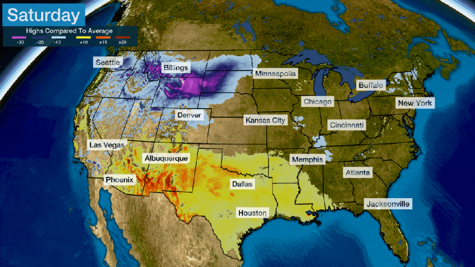 The blue shadings show areas that will have below-average highs. Yellow and orange shadings represent above-average highs. Locations not shaded will be within a few degrees of average.
Highs in the 70s to low 80s are expected from the Northern Plains to the Midwest and Northeast. For some cities, these highs will be near average to a few degrees below for early August, which is tolerable when compared to the 90-plus-degree heat waves possible this time of year.
The most significantly below-average highs will be from the northern Rockies into portions of the Plains and Midwest. You can see how the forecast highs compare to the daily average for select cities below.
On top of that, lows will dip into the comfortable 50s and lower 60s as the cooler air spreads eastward through the Plains and Midwest this weekend into early next week.
Heat fatigued areas from Texas to the Southwest won't see any relief. Triple-digit highs will continue to be commonplace in Texas through early next week, including more daily records in parts of the state. The heat dome will pile on to last month's all-time record heat in the Desert Southwest, including Phoenix, which will be in the midst of a new stretch of 110-plus-degree highs.
(MORE: July Was Record Hot In Phoenix And Other Southwest Cities)

Chris Dolce has been a senior meteorologist with weather.com for over 10 years after beginning his career with The Weather Channel in the early 2000s.
The Weather Company’s primary journalistic mission is to report on breaking weather news, the environment and the importance of science to our lives. This story does not necessarily represent the position of our parent company, IBM.
The Weather Company’s primary journalistic mission is to report on breaking weather news, the environment and the importance of science to our lives. This story does not necessarily represent the position of our parent company, IBM.


No comments:
Post a Comment