Jonathan Belles
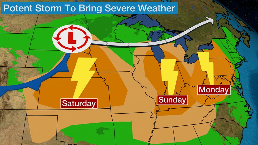
A potent low pressure system will blast through the Midwest and into the Northeast bringing the potential for severe weather this weekend into early next week.
Unlike in recent days, a different storm path will take shape in the coming days. Recent storms have taken up a lane around the dome of high pressure that has stretched from the northern Rockies through the mid-Mississippi Valley and Southeast.
You can see where storms are now below:

(MORE: Daily Planner)
This storm track, however, will be closer to an autumn-like pattern that will take a low pressure system from the Northern Plains through the Great Lakes and into southeastern Canada or the interior Northeast.

To the south of this storm track, severe weather is possible where a slicing cold front will undercut summertime humidity and an injection of strong winds aloft.
Let’s step through the forecast day by day:
Saturday: Severe threat begins from Central Plains to mid-Missouri Valley. Some morning showers and thunderstorms are possible in parts of Iowa, Kansas, Missouri and Nebraska, but the potential for a bigger threat exists during the afternoon or evening hours in a similar area as outlined below. Damaging straight-line winds and large hail are the primary threats from any storms that turn severe.
There is some uncertainty on the placement and severity of the storms in the second round due to uncertainty over how much the atmosphere will recover after the first round. If recovery is swift, storms may be more defined and stronger.
The general thinking is that storms will develop in Nebraska and Kansas (or possible as far west as eastern Colorado) and head eastward through the evening and into the overnight hours.
 Saturday's Severe Thunderstorm Forecast
(AUGUST IS HERE: What Typically Happens in the Weather This Month)
Sunday: Threat shifts to southern Great Lakes, Ohio Valley. As the low pressure system moves eastward there will be some potential for severe storms in the Midwest, including an isolated tornado threat.
Severe weather is most possible from southern Wisconsin and southern Michigan southward to much of Illinois, Indiana, western Ohio, southeast Missouri, western and central Kentucky and northern Tennessee. Damaging winds and large hail are the primary threats from these storms.
There is a limited threat of a few tornadoes and these will be most possible in northern parts of the severe weather threat area shown below. Those locations will be just south of where the main low pressure system tracks, or where humidity, wind shear and lift align.
There may be some limited flood potential near where the low pressure system tracks or in Wisconsin, as the system moves through.
 Sunday's Severe Thunderstorm Forecast
(MORE: Does it Get Hotter than This?)
Monday: Interior Northeast, mid-Atlantic severe threat possible. By Monday, the storm system will track into southern Canada and the main threat will be damaging wind gusts.
The most likely spot for severe weather is from the central Appalachians up into western and central New York. Some of the severe weather could spread as far east as the Interstate 95 corridor, including from Philadelphia to Washington, D.C.
 Monday's Severe Thunderstorm Forecast
Jonathan Belles has been a graphics meteorologist and writer for weather.com for 7 years.
The Weather Company’s primary journalistic mission is to report on breaking weather news, the environment and the importance of science to our lives. This story does not necessarily represent the position of our parent company, IBM.
The Weather Company’s primary journalistic mission is to report on breaking weather news, the environment and the importance of science to our lives. This story does not necessarily represent the position of our parent company, IBM.

No comments:
Post a Comment