...COASTAL FLOOD STATEMENT IN EFFECT FROM THIS EVENING THROUGH LATE TONIGHT...
* WHAT...Up to one half foot of inundation above ground level expected in vulnerable areas near the waterfront and shoreline. * WHERE...In Connecticut, Southern Fairfield County. In New York, Southern Westchester County. * WHEN...From this evening through late tonight. * IMPACTS... Brief minor flooding of the more vulnerable locations near the waterfront and shoreline. * ADDITIONAL DETAILS...Localized minor coastal flooding is possible during times of high tide Friday, especially at night. PRECAUTIONARY/PREPAREDNESS ACTIONS... Do not drive through flooded roadways.Thursday, August 31, 2023
LIVE: Idalia churns through Carolinas with life-threatening hazards
Despite losing wind intensity over land, Idalia remained an extremely dangerous storm as it raced across the Southeast on Wednesday, packing life-threatening storm surge, damaging winds, tornadoes and flooding rain.
Electric customers across parts of Florida, Georgia, South Carolina and North Carolina are without power this morning in the wake of Idalia. Outages across the four states on Thursday morning were around 309,000, according to PowerOutage.us, down from the nearly half a million that were facing outages on Wednesday afternoon. However, some of the hardest-hit regions of Florida and Georgia could face outages into the weekend as utility crews work to repair broken lines and snapped power poles. On Wednesday, Duke Energy Lead Communications Manager told AccuWeather that extensive damage and flooding were impacting the company’s ability to restore power in parts of Florida, but power restoration work will begin when the weather conditions are safe for utility crews.

By nighttime on Aug. 30, hundreds of thousands of households remained without electricity due to Hurricane Idalia, but crews were dispatched throughout the Southeast to survey the damage.
Early risers in the New York City area were treated to a beautiful sunrise on Thursday morning with orange, pink and purple clouds appearing over the world-famous skyline. And the colorful sight would not have happened if it was not for Tropical Storm Idalia. Although the center of Idalia is hundreds of miles south of the city and no tropical downpours are in the forecast, clouds on the northern fringe of the storm spread across the region. A camera on the Statue of Liberty operated by EarthCam snapped a photo of the sunrise, which showed patchy clouds in various colors sprawled out over the entire New York City area.

A colorful sunrise over New York City on Thursday, Aug 31, created by clouds on the northern edge of Idalia. (EarthCam)
The clouds are forecast to depart the mid-Atlantic by the afternoon as Idalia tracks out to sea, giving way to a dry and sunny day across the region. However, the clouds may linger longer in North Carolina, where Idalia was still delivering heavy tropical rain at daybreak on Thursday.
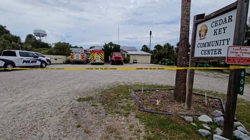
Cedar Key, Florida, was bombarded by significant storm surge and intense wind as the eye of Idalia passed just west of the town on Wednesday morning. Extreme Meteorologist Reed Timmer rode out the hurricane in Cedar Key, located 85 miles northwest of Tampa, and reported from the scene leading up to, during and immediately following Idalia. "This is the only place where you can get gas," Timmer said. "Now the gas station has largely been destroyed." He added that the only bridge that connected Cedar Key to the Florida Peninsula was temporarily closed, trapping people in the town until the damage and debris could be cleared. Watch Timmer's full report below.
Extreme Meteorologist Dr. Reed Timmer has a look at the damage in Cedar Key, Florida, where not only storm surge created by Idalia, but also destructive winds created havoc for residents.

A snapshot of the radar around 5:30 a.m. EDT Thursday showing heavy rain from Idalia falling over portions of Virginia, North Carolina and South Carolina. (AccuWeather)
Less than 24 hours after making landfall along Florida's Gulf coast, the center of Idalia is back over water, emerging over the Atlantic Ocean after tracking across Florida, Georgia and the Carolinas. While the center of the storm may be over water, Idalia is still spreading heavy rain over part of the East Coast with multiple flash flood warnings in effect across North Carolina. Over the past 24 hours, Wilmington, North Carolina, has measured 5.20 inches of rain, with more possible before Idalia departs. AccuWeather meteorologists say that Idalia will continue on an eastward trajectory into the weekend and may impact Bermuda on the heels of Hurricane Franklin.
The tenth named storm of the 2023 Atlantic hurricane season took shape early Thursday morning as a tropical depression southeast of Bermuda strengthened into Tropical Storm Jose. As of 5 a.m. EDT Thursday, the time at which the National Hurricane Center upgraded the system to a tropical storm, Jose had maximum sustained winds of 40 mph and was tracking northward at 5 mph. On its current course, Jose is not predicted to impact land.
AccuWeather meteorologists are also monitoring an area near Jose, the remains of former Tropical Storm Gert, that could reorganize into a tropical storm. Another disturbance off of the western coast of Africa could also give birth to a new tropical depression or named tropical storm.

A satellite image showing Idalia along the coast of the Carolinas, Franklin near Bermuda, Jose near the middle of the Atlantic and a tropical wave off of the coast of Africa. (NOAA/GOES-EAST)
On Wednesday evening, a tornado warning was issued for the Cherry Grove area of South Carolina as a rain band from Tropical Storm Idalia pushed onto the coast. Cherry Grove is situated less than 20 miles northeast of Myrtle Beach. By the late evening hours, an apparent tornado crossed the area, leaving behind structural damage including at least one roof being torn from a home, according to North Myrtle Beach Emergency Response. As the rain band swept through Myrtle Beach, a wind gust over 30 mph occurred at Myrtle Beach International Airport.
In the event of an extended power outage, particularly following hurricanes and other severe weather, having a generator at home can be a huge advantage. But if used improperly, the devices can seriously harm or kill unsuspecting families.
Carbon monoxide poisoning, electrocution and fire are all potentially fatal risks of misusing portable generators. Get a list of important tips for running generators to keep your family safe.
Despite all the damage that hurricanes do, they can leave behind brilliant sunsets. This was true in the mid-Atlantic and Northeast U.S. as Wednesday came to a close when the area was just north of Tropical Storm Idalia. Cirrus cloud shields on the edge of tropical storms are responsible for the enhanced sunsets.

As Tropical Storm Idalia moved northeast through the Carolinas Wednesday evening, winds came in from the east, causing a significant storm surge at coastal locations in South Carolina.
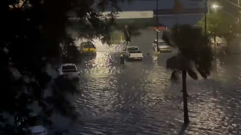
AccuWeather’s Emmy Victor reported live from the scene of worsening floods in Charleston, South Carolina, on the night of Aug. 30, showing the deteriorating conditions in the city.
In Charleston, South Carolina, the blue moon made the storm surge worse, with a video showing feet of water downtown at 8:30 p.m. EDT. A NOAA tidal gauge registered a storm surge of almost 2 and a half feet at that location. The total water level was recorded as 3.47 feet, preliminarily ranking it number five, just below Hurricane Irma in 2017 and Matthew in 2016.
At Springmaid Pier in Myrtle Beach, the water reached 9.1 feet, ranking as the number six highest measurement since the 1980s, but falling short of Ian last year, which caused waters to rise to 10.5 feet.

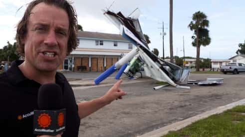
AccuWeather National Reporter Bill Wadell was live on the AccuWeather Network Wednesday morning from Perry, Florida, as Idalia, then a Category 3 hurricane, moved over the town. Wadell was standing in a parking lot and was shielded by a vehicle from the windswept rain when he witnessed debris flying through the air. “All sorts of materials here flying around,” Wadell said. And it was more than just signs and debris that was being blown away by the wind. “A porta potty went flying right across the street,” Wadell said.
Seconds before Wadell was about to end his broadcast, a stronger gust howled across the parking lot and sent his hat flying. “There goes the hat,” he said, adding that all of his bright orange AccuWeather hats have blown away. Watch Wadell’s full interview below.
On the morning of Aug. 30, AccuWeather’s Bill Wadell was in Perry, Florida, where Hurricane Idalia’s winds ripped apart signs and roofs of businesses and turned the debris into projectile missiles.
Homes in Horseshoe Beach, Florida were surrounded by a pounding storm surge that destroyed them Wednesday morning. This video, taken by a game camera mounted to a power pole, shows the last moments these homes stood as the water surrounded them. A NOAA sensor at nearby Cedar Key measured a storm surge of nearly 9 feet.
AccuWeather forecasters say that Idalia may take a meandering path or even stall for a bit offshore after it emerges from the southeastern United States coast. “The latest indications are that after a stall or southward dip for a day or two, the storm may resume a northeastward movement next week,” AccuWeather Senior Meteorologist Alex Sosnowski said.

As it wanders around in the Atlantic, what is left of the storm can enhance downpours and cause gusty and locally damaging winds in Bermuda. Rain totals of 1-2 inches could greatly increase if the storm stalls in the vicinity of the island nation. Gusts of at least 40-60 mph are expected. That will be the second tropical threat for the island nation within the week as Category 2 Hurricane Franklin will zip by to the northwest through Wednesday night, unleashing gusty winds and rough surf.
AccuWeather’s preliminary estimate of the total damage and economic loss from Hurricane Idalia in the southeastern United States is $18 billion to $20 billion. Idalia made landfall as a Category 3 hurricane in the Big Bend area of Florida with maximum sustained winds of 125 mph. It brought record and destructive storm surge to parts of Florida’s Gulf Coast. Coastal inundation and surge levels where the storm moved inland rivaled those of Hurricane Ian in Fort Myers last year. However, the Big Bend area of the state is far less populated than the area devastated by Ian, accounting for a vast difference in total damages. The population was approximately 1 million within 30 miles of Ian’s landfall. In comparison, about 38,000 people live within that distance of Idalia’s landfall.

To put Idalia’s damage cost into context, Hurricane Ian caused a loss of $180 billion to $210 billion, according to AccuWeather. Hurricane Michael in 2018 devastated parts of the Florida Panhandle, again in a slightly more populated area than Idalia, with a total damage and economic loss of about $30 billion. AccuWeather estimated the damage of the wildfires in Hawaii was $14-16 billion.
A video from a highway in Goose Creek, South Carolina, northwest of Charleston, shows a car being flipped by what the National Weather Service described as a brief, weak tornado that touched down in a heavy rain band from Hurricane Idalia Wednesday afternoon. WCBD reported that two people were injured.

Footage taken in Goose Creek, South Carolina, shows the tornado lift and then toss the car onto another car on Aug. 30.
The incident took place while the center of Idalia was over Jennings, Florida, 240 miles to the southwest. A tornado watch was in effect for coastal South Carolina at the time. Small, sudden tornadoes can occur during hurricanes without warning, far from the center.
NOAA Doppler Radar data indicated that Idalia’s maximum sustained winds were 70 mph as of 5 p.m. EDT Wednesday, according to the National Hurricane Center (NHC). That means Idalia is now at tropical storm strength as it spins over southeastern Georgia, about 40 miles west of Savannah.

AccuWeather forecasters warn that the dangers from Idalia are still far from over as storm surge, flooding rain, damaging winds, and isolated tornadoes will remain concerns from portions of Georgia to the Carolinas. Even in the storm’s aftermath across Florida, dangers such as carbon monoxide poisoning for those running generators and live wires will pose risks to residents trying to clean up from Idalia.
AccuWeather National Reporter Bill Wadell reported from Perry, Florida, in front of an apartment building with serious damage from Hurricane Idalia on Wednesday. The roof and a brick wall of the complex were ripped right off by the storm’s powerful winds. Dewayne Williams, a resident of the building, recounted the terrifying ordeal with Wadell. He said he grabbed his 3-year-old son and ran downstairs as the roof started blowing off, and water was going everywhere. “Everything was gone,” Williams said, “but you gotta bounce back from it, I guess.”
Another resident, Dillon Gregory, told Wadell, “It just came on us all at once. Bricks started falling close to our patio. It was crazy.” Officials are warning residents to watch out for live power lines as they begin to assess the damage and clean up, Wadell reported.
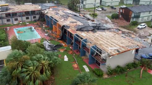
AccuWeather’s Bill Wadell was in Perry, Florida, where an apartment building was damaged after Hurricane Idalia swept through the region on Aug. 30.
Around 440,000 electric customers across Florida and Georgia are without power, a number that continues to rise, according to PowerOutage.us. Nearly 300,000 of the outages are in Florida alone, including over 95% of customers in Jefferson, Madison, Suwannee and Taylor counties. The eye of Idalia moved over these four counties early Wednesday morning when the hurricane was at Category 3 strength. Outages are also starting to tick upward in South Carolina and North Carolina as gusty winds from Idalia pick up across the states.
Strong winds are doing more than knocking out the power. Countless trees have been blown over or snapped by Idalia’s wrath, with some trees falling on homes, including one house in Perry, Florida, while a resident was recording video of the storm.
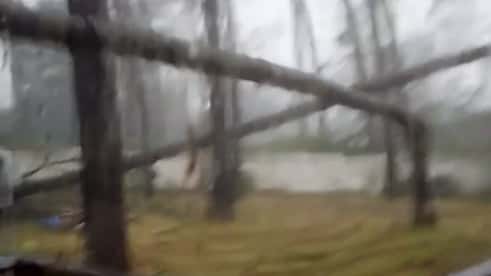
This video shows the scary moment when two trees fell down in the midst of Hurricane Idalia on Aug. 30. One of the trees fell dangerously close to the home and frightened the homeowner’s child.
Storm chaser Brian Emfinger used a drone to film destruction caused by Hurricane Idalia in Keaton Beach, Florida, near where the storm made landfall. One home had a missing roof and walls, but within the same home, a bed still sat with sheets on and a TV hung intact on a nearby wall. Debris turned into dangerous missiles while being tossed through the air in the Keaton Beach area.
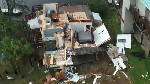
Drone video from storm chaser Brian Emfinger shows homes destroyed by Hurricane Idalia on Aug. 30, at Keaton Beach, Florida. Theirs was one of many homes that sustained heavy damage in the region.
At least two deaths are being blamed on Idalia as the hurricane continues to carve a path across the Southeast. Two Florida men were killed in weather-related car accidents on Wednesday, CNN reported. Florida Highway Patrol Sgt. Steve Gaskins added that the men died in separate crashes. Details surrounding the incidents are still unclear at this time. Although Idalia has lost wind intensity since making landfall on Wednesday morning, residents should remain vigilant as it remains a Category 1 hurricane with sustained winds of 85 mph, and could spin up tornadoes into Wednesday night.
1/25
TARPON SPRINGS, FLORIDA - AUGUST 30: In an aerial view, a fire is seen as flood waters inundate the downtown area after Hurricane Idalia passed offshore on August 30, 2023 in Tarpon Springs, Florida. Hurricane Idalia is hitting the Big Bend area of Florida. (Photo by Joe Raedle/Getty Images)

Kiosks at the Southwest Airlines ticket counter are covered in protective wrapping at the Tampa International Airport, Tuesday, Aug. 29, 2023, in Tampa, Fla. The airport closed to all air travel early Tuesday as residents along Florida's gulf coast are making preparations for the effects of Hurricane Idalia. (AP Photo/Chris O'Meara)
Idalia has grounded scores of flights across the United States, causing travel headaches for airline passengers across the nation. Around 1,000 flights across the country have been canceled and another 2,000 delayed, according to Flight Aware. The majority of the delays and cancellations are related to airports across the Southeast that have faced impacts from Idalia. However, there is good news on the horizon.
Tampa International Airport, which closed on Tuesday before Idalia arrived, announced that it will be resuming operations as the hurricane moves away from Florida. The airport will be open to arriving flights starting at 4 p.m. EDT Wednesday, with departing flights resuming early Thursday morning. “TPA is fortunate to have avoided the worst effects of such a dangerous storm, after acting in an abundance of caution to protect the safety of our passengers, employees and facilities,” Tampa International Airport CEO Joe Lopano said. “We’re focused now on returning to full operational capacity to continue serving our community and to assist in recovery efforts for our fellow Floridians.” Travelers are still encouraged to check the status of their flight before heading to the airport.
Hurricane Idalia triggered an intense storm surge as seen in footage captured in Cedar Key, Florida, on Wednesday morning. Video shows high water slamming into a building there, a good example of how the speed and motion of storm surge add to the destruction a hurricane can unleash. Elsewhere, fierce winds and rain pounded Perry, Florida, as storm chaser Aaron Rigsby filmed the storm’s onslaught. AccuWeather National Reporter Bill Wadell said that powerful winds from Idalia blew trees down onto homes in Perry, Florida. Watch wild footage of Idalia in action:
Idalia has lost wind intensity since moving inland and is now a Category 1 hurricane with maximum sustained winds of 90 mph, but the storm is far from over. A tornado watch was issued for parts of South Carolina and North Carolina through 10 p.m. EDT. Nearly 2 million people are under the watch, which includes Charleston and Myrtle Beach, South Carolina, and Wilmington, North Carolina. Portions of Florida and southeastern Georgia remain under a tornado watch that was issued on Tuesday night ahead of Idalia making landfall.

A large tree blocking part of Interstate 10 east of Tallahassee, Florida, on Wednesday morning. (AccuWeather/Tony Laubach)
The worst of Idalia’s wind may be over in Florida, but conditions are still dangerous for motorists in parts of the state. AccuWeather Meteorologist and Storm Chaster Tony Laubach was navigating a section of Interstate 10 east of Tallahassee when he came across an area that was almost completely blocked by a large tree that was blown over during the hurricane. Laubach also came across trees that were snapped in Lee, Florida, where Idalia’s eye tracked overhead earlier on Wednesday morning. People in the area should avoid travel if possible to allow crews to clear any debris that is on the roads.
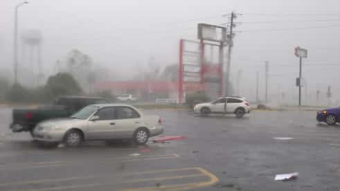
Storm chaser Mike Scantlin reported live for AccuWeather from Idalia’s eyewall in Perry, Florida, on Wednesday morning amid extreme rain and wind. At the time of his recording, Idalia was a Category 3 hurricane. He noted that he was about to hunker down in a shelter as conditions escalated. “Oh, wow!” Scantlin shouted, noting that 110 mph plus wind gusts were howling, causing a transformer to explode. Watch his full report below.

Storm chaser Mike Scantlin describes conditions in the eyewall of Hurricane Idalia as it makes landfall near Perry, Florida, on Aug. 30.
Storm Chaser Aaron Jayjack intercepted the eye of Idalia in Perry, Florida, on Wednesday morning as the eyewall -- the most intense part of a hurricane -- moved through the town. Perry is located about 20 miles north of where Idalia made landfall. A video clip from the town showed trees bending over and touching the ground, with visibility significantly reduced due to the wind-driven rain. The number of power outages in Florida has spiked to more than 240,000, according to PowerOutage.us. Outages may soon be on the rise in Georgia as conditions deteriorate as Idalia tracks northeastward.
1/25
TARPON SPRINGS, FLORIDA - AUGUST 30: In an aerial view, a fire is seen as flood waters inundate the downtown area after Hurricane Idalia passed offshore on August 30, 2023 in Tarpon Springs, Florida. Hurricane Idalia is hitting the Big Bend area of Florida. (Photo by Joe Raedle/Getty Images)
Catastrophic storm surge is occurring along the coast of Florida’s Big Bend as Idalia moves inland as a Category 2 hurricane, packing maximum sustained winds of 110 mph. Wind gusts up to 85 mph have been recorded in Perry and Mayo, Florida, and an 81-mph gust was measured in Horseshoe Beach, Florida. A webcam located 10 feet above sea level was destroyed at Horseshoe Beach as Idalia crashed ashore with monstrous wave action. Storm surge has reached as high as 8.88 feet at Cedar Key, Florida, as of 8:30 a.m. EDT. Old Port Tampa has already established a new record water level with a storm surge of around 5 feet above mean higher high water (MHHW). The previous record occurred during Hurricane Eta on Nov. 12, 2020.
Hurricane Idalia is pounding Florida’s Big Bend with intense winds and powerful storm surge, and for some storm chasers, it is getting to be too much. Extreme Meteorologist Reed Timmer, who is stationed in Cedar Key, recorded a brief video from a bridge around the same time that Idalia was making landfall. “We are now going to retreat to our shelter,” Timmer said in a video, adding that the storm surge was getting worse. Watch Timmer’s full report below:

A satellite image of Hurricane Idalia as it made landfall in Florida on Wednesday morning. (NOAA/GOES-EAST)
The eye of Idalia roared ashore early Wednesday morning with the storm making landfall near Keaton Beach, Florida, at 7:45 a.m. EDT. Maximum sustained winds were 125 mph at the time of landfall, making it a Category 3. Idalia lost some wind intensity on its final approach, with maximum sustained winds peaking at 130 mph late Tuesday night, the minimum wind speed required to be classified as a Category 4. The National Hurricane Center emphasized that the “change in wind speed does not diminish the threat of catastrophic storm surge and damaging winds.” AccuWeather meteorologists warn that Idalia will continue to pack a punch as it sweeps just inland of the Southeast coast.
The eye of Hurricane Idalia is nearing the Florida coast with maximum sustained winds of 125 mph, making it a Category 3 storm. The National Weather Service office in Tallahassee, Florida, has issued an extreme wind warning, calling it “AN EXTREMELY DANGEROUS AND LIFE THREATENING SITUATION.” The coastal towns of Steinhatchee, Dekel Beach and Horseshoe Beach are included in the warning.

The number of power outages is creeping upward with nearly 66,000 outages as of 6:25 a.m. EDT Wednesday, according to PowerOutage.us. This number is up from 44,000 from two hours prior, and outages are expected to climb throughout Wednesday as Idalia makes landfall and moves inland. AccuWeather forecasters say "widespread" outages are possible across northern Florida and into parts of Georgia and South Carolina. People who have generators as a backup source of power should follow proper generator safety guidelines to avoid carbon monoxide poisoning.

AccuWeather is spread across Florida ahead of Idalia's landfall, which is expected near the coastal town of Steinhatchee between 7 a.m. and 8 a.m. EDT Wednesday. Three chasers, including Extreme Meteorologist Reed Timmer, are stationed in Cedar Key where catastrophic storm surge is predicted to exceed 10 feet. AccuWeather National Reporter Bill Wadell is located in Mayo, about 30 miles inland from where Idalia will roar ashore. Emmy Victor is already in place in Charleston, South Carolina, to cover the storm as it tracks over the Southeast in the coming days.

A satellite image of Hurricane Idalia as it neared the Florida coast early Wednesday morning as a Category 4 storm. (NOAA/GOES-EAST)
Overnight, Idalia has evolved into a catastrophic hurricane, becoming a Category 4 hurricane with maximum sustained winds of 130 mph. The pressure in the core of the storm has plummeted, and nearly constant lightning has been detected in the eye, two signs that it could strengthen further before making landfall on Wednesday morning. "This is a life-threatening situation," the National Hurricane Center said at 5 a.m. EDT when it upgraded Idalia to a Category 4. "Persons located within these areas should take all necessary actions to protect life and property from rising water and the potential for other dangerous conditions." The eye of Idalia is located about 60 miles west of Cedar Key, Florida, and it is moving north-northeast at 18 mph.
As AccuWeather meteorologists track Idalia, which is expected to strengthen into a formidable and dangerous hurricane before bearing down on Florida, they have noted that some of the most notorious tropical storms in history have begun with the letter “I.” Just in recent years, Ian, Ida and Irma all wreaked havoc and left behind death and destruction in the United States.

Since 1954, 14 storms beginning with the letter “I” (including Iota 2020, a name which is technically a letter of the Greek alphabet) have been retired. That accounts for a significant number compared to the runner-up, “F,” which has only 10 retired storms. Why have more storms starting with the letter “I” been retired than any other letter? The answer is not what you might think.
As of midnight Tuesday evening, AccuWeather is now forecasting that Hurricane Idalia will be a dangerous Category 4 hurricane at landfall. The AccuWeather Local StormMax™ for wind gusts is now 165 mph. Storm surge could exceed 15 feet in some areas. The AccuWeather RealImpact™ Scale for hurricanes now rates Idalia as a 4, with catastrophic damage expected.


AccuWeather’s Tony Laubach reported live amid booming thunder, cracks of lightning and pouring rain in Lake City, Florida, on the night of Aug. 29.
As an illustrative example of how severe weather can be hundreds of miles from a hurricane's center, AccuWeather Meteorologist Tony Laubach checked in with the AccuWeather Network Tuesday evening during a thunderstorm in Lake City, Florida.
That town sits almost 200 miles from the center of the storm. The National Weather Service noted that the storm in Lake City had "excessive lightning" and a tornado watch remained in effect just to the south of Tony's location.
It won't be the last interesting report Tony files; Hurricane Idalia's center will likely track closely to Lake City on Wednesday morning.
The last hurricane to hit inland from Apalachee Bay, Florida, within 30 miles of Steinhatchee, was a Category 2 hurricane in 1935. That storm had weakened from its Category 5 strength when it made landfall in southern Florida. The infamous storm is known as the Labor Day Hurricane, the most intense hurricane to ever hit the United States.

The 1935 Labor Day Hurricane is depicted on a weather map. (NOAA)
Expanding the search area to include the entirety of Apalachee Bay finds only three additional hurricanes since 1935: Alma in 1966 and Hermine in 2016 south of Tallahassee, and an unnamed hurricane in 1949 that hit near Cedar Key -- all three were Category 1 storms. That means most residents who live within the predicted landfall area do not have any historical storm to look back on to judge what damage Idalia may do, and Idalia may be much stronger than any of the previous storms to strike the region when it hits.
The population within a 30-mile radius of Steinhatchee, Florida is 38,000. While those residents will see immense damage from Idalia, the population in the same area of Hurricane Ian’s landfall in 2022 was almost one million.
Additional hurricanes struck the area prior to 1935, including a Category 3 storm in 1886, south of Tallahassee, and a Category 1 hurricane in 1867 which hit just south of Steinhatchee, but little is known about these storms.
Storm chaser Aaron Rigsby reported from Cedar Key, Florida, where the streets were empty as residents evacuated to higher ground ahead of an expected storm surge of more than 10 feet.
AccuWeather storm chaser Aaron Rigsby reported Tuesday evening that streets were deserted in Cedar Key, Florida, and emergency vehicles had been moved to the highest point, 22 feet above sea level. Some residents who originally said they would stay are now considering evacuation, Rigsby added.
AccuWeather's Kevin Coskren interviewed CNN Newsource's Gloria Pazmino in Clearwater Beach Tuesday evening. Pazmino says that most people appear to be heeding evacuation orders as conditions deteriorate, and confirmed that police in Cedar Key went door to door asking residents to evacuate.
A Tornado Watch was issued for much of the western Panhandle of Florida at 8:30 p.m. EDT, effective until 6 a.m. EDT Wednesday. Tornadoes spawned by hurricanes are not unusual and can hit far from the center of the storm's path.
At 8 p.m. EDT, Hurricane Idalia's sustained winds increased to 105 mph, according to the National Hurricane Center. Storm surge was reported to be nearly 2 feet at Naples and Clearwater Beach, Florida. AccuWeather radar showed the storm looming 155 miles west-southwest of Tampa.

Hurricane Idalia remains a 3 on the AccuWeather RealImpact™ Scale for hurricanes, due to the widespread and substantial flooding expected, along with structural damage to buildings, downed trees, power outages and major coastal inundation.
A plane being evacuated from MacDill Air Force Base in Tampa, Florida, Monday night due to Hurricane Idalia recorded St. Elmo's Fire, a lightning-like weather phenomenon that is a coronal discharge of plasma from objects, typically airplanes or ships.
The phenomenon was named after Saint Erasmus, the patron saint of sailors. It was considered good luck. St. Elmo's Fire forms when there's a difference in charge between the air and a charged, pointed object.
Hurricane Idalia is forecast to make landfall in Florida on Wednesday, the same day that a full supermoon will occur. The gravitational pull of the moon is responsible for the tides, and during a supermoon when the moon is a bit closer to the Earth, its influence can be more pronounced. A high tide is predicted for late Tuesday night, followed by another high tide early Wednesday afternoon. “We don’t want people to let their guard down,” AccuWeather Chief Meteorologist Jon Porter said, noting that he is particularly concerned about the afternoon high tide in places like Tampa Bay when people may think the worst of the storm’s surge is past.
In Tampa Bay, a high tide is predicted to occur at 4:07 a.m. EDT Wednesday, followed by another high tide at 2:28 p.m. EDT. Although the center of Idalia is forecast to track west of Tampa, the winds on the eastern side of the storm will cause water to pile up in the bay, resulting in significant coastal flooding.
Floodwaters inundated some coastal areas in southwestern Florida and the Florida Keys on Tuesday afternoon as Hurricane Idalia churned over the eastern Gulf of Mexico. Outer rain bands arrived well ahead of the dangerous storm, and a storm surge as high as 1.66 feet was measured in Clearwater Beach, Florida, as of 4:30 p.m. EDT. In some videos shared via social media, people could be seen walking through Idalia’s floodwaters in coastal areas. AccuWeather forecasters warn that conditions will get worse throughout the night and strongly urge people to heed all warnings from officials, stressing that water is the most deadly aspect of hurricanes.

Category 2 Hurricane Idalia churns over the eastern Gulf of Mexico on Tuesday evening, Aug. 29, 2023 (AccuWeather Enhanced RealVue™ Satellite)
Idalia’s maximum sustained winds have increased to 100 mph, making it a Category 2 hurricane on the Saffir-Simpson Hurricane Wind Scale. The storm was churning about 195 miles southwest of Tampa, Florida, as of 5 p.m. EDT Tuesday, according to the National Hurricane Center (NHC). Data from Air Force Reserve Hurricane Hunter aircraft indicated the increase in wind intensity Tuesday afternoon. Idalia was moving to the north at 16 mph.
AccuWeather National Reporter Bill Wadell was live in Pasco County, Florida, roughly an hour north of Tampa, on Tuesday speaking with families who are bracing for Hurricane Idalia’s wrath in quiet coastal communities.
Christa McDonald, a Hudson, Florida, resident, told Wadell that it will flood where she lives. She’s retrieving her boat from the water and moving her family to safety away from the water. But she’s concerned for those who are not evacuating and staying along the coast. “Unfortunately, they’re looking to get it, probably the worst. Hopefully, it keeps going away from us, but you’ve got to be prepared. ’Cause all too many times we think it’s coming for us and it doesn’t,” McDonald said, “and this could be the one.”
Wadell spoke with others who plan to stay behind. Watch his full report below:
People who live near the coastline and canals of Pasco County, Florida, say they’re preparing for storm surge and flooding from Idalia.
1/9
Adam Henderson, owner of Harbour Master Suites, prepares his business ahead of the expected arrival of Hurricane Idalia, Tuesday, Aug. 29, 2023, in Cedar Key, Fla. The hurricane is now forecast to become an extremely dangerous Category 3 storm, pushing a storm surge of up to 12 feet. (AP Photo/Rebecca Blackwell)
Residents and business owners have been busy prepping for Hurricane Idalia early this week as officials and forecasters alike issued stark warnings about the storm and its dangers, particularly related to life-threatening storm surges. Sand-bagging operations have been underway in Idalia’s path as windows and doors have been boarded up in vulnerable areas along Florida’s Gulf Coast, including Cedar Key and Indian Rocks Beach. Store shelves were cleared out in advance of the hurricane’s arrival.
“It’s absolutely faster than it was before,” Tampa, Florida, resident Madeleine Mejean told AccuWeather National Reporter Bill Wadell about her experience gathering sandbags early this week. “Usually it’s like ‘OK, bring a shovel, you’re putting your own sand in the bags’ and stuff, and whatever machine they have going seems to really be working. This line, I’ve been here for an hour now and it’s moving very smoothly.”
People all along Florida’s Gulf Coast are making final preparations for Hurricane Idalia, including in Fort Myers, Florida, a city devastated by Hurricane Ian last September. Kevin Anderson, Mayor of Fort Myers, said that some homeowners still have blue tarps on their roofs as they continue to deal with the long-lasting fallout from last year’s catastrophic hurricane. He also warned of the dangers of storm surge. “While you can hide from the wind, you’ve got to run from the water,” Anderson said. Watch Anderson’s interview about Hurricane Idalia below:
Fort Myers, Florida, Mayor Kevin Anderson explains how there are still homes with blue tarps with Hurricane Idalia approaching. He also shares one statement about the high risk of coastal flooding.

A radar snapshot shows Hurricane Idalia's outer rain bands soaking portions of the Florida Keys and the southwestern coast of Florida on Tuesday, Aug. 29, 2023. (AccuWeather's Interactive Radar)
Hurricane Idalia remained a Category 1 hurricane but its maximum sustained winds increased to 90 mph as of 2 p.m. EDT Tuesday, according to the latest advisory from the National Hurricane Center (NHC). Sustained winds are just 5 mph shy of Category 2 strength. “Satellite images indicate that Idalia continues to strengthen,” the NHC stated. Hurricane-force winds only extended 15 miles out from the storm’s center, but tropical-storm-force winds reached outward up to 160 miles. As the storm picked up steam and also forward motion, with Idalia moving north at 15 mph, outer rain bands began drenching the southwestern coast of Florida on Tuesday afternoon
The center of Hurricane Idalia is still over the open waters of the eastern Gulf of Mexico, but tropical downpours on the eastern side of the strengthening storm have already arrived in parts of Florida. A webcam in Key West, Florida, showed massive waves crashing ashore on Tuesday morning, along with gusty winds and torrential downpours. A weather station in Key West clocked a 48-mph wind gust around midday Tuesday.

Waves crashing into Key West, Florida, on Tuesday morning. (Southernmost Point Webcam)
Rain and thunderstorms have also arrived in the southwestern Florida Peninsula and are knocking on the doorstep of Tampa. However, it is still dry and hot in Tampa with an AccuWeather RealFeel® Temperature flirting with the 100-degree mark. The temperature is forecast to drop as rain from Idalia arrives.
Hurricane Idalia is projected to make landfall near the Big Bend area of Florida, just southeast of Tallahassee. AccuWeather meteorologists say that some of the worst conditions may unfold in Cedar Key, Florida, a town along the state’s coast that juts out into the Gulf of Mexico. While the eye of the hurricane is not forecast to make landfall in Cedar Key, the right front quadrant of the hurricane will pass over the town, the part of the storm that packs the strongest wind and often generates the worst storm surge.

Wind gusts up to 140 mph are possible in Cedar Key, gusts strong enough to cause significant damage. Additionally, a storm surge of up to 15 feet is possible that will inundate the coastline. Water that high would submerge the entire first floor of a house along the coast. Conditions will deteriorate throughout Tuesday and Tuesday night as the storm nears, with the worst of the weather in Cedar Key expected between 5 a.m. EDT and 12 p.m. EDT Wednesday.
A new tropical depression was declared by the National Hurricane Center at 11 a.m. EDT. The depression, designated as Tropical Depression Eleven, currently has sustained winds of 35 mph and is moving northward over the open waters of the Atlantic at 2 mph. The storm is expected to be short-lived and remain well off shore where it may briefly reach tropical storm strength, becoming Tropical Storm Jose, before losing wind intensity Thursday afternoon.
Storm surge from Idalia is expected to impact a wide area, stretching from the west coast of Florida northward to the coast of South Carolina. “The greatest storm surge will be from Cedar Key, Florida, to just west of Apalachicola, Florida, where 6 to 12 feet of surge is expected," AccuWeather Lead Hurricane Expert Dan Kottlowski said, a rare blue supermoon expected on Wednesday can further intensify any surge.

While hurricanes are often noted for their intense winds, storm surge kills more people than any other hurricane-driven risk according to Kottlowski. That is because storm surge occurs over a larger area compared to the more localized high winds within a hurricane. AccuWeather meteorologists urge those living in the Big Bend area of Florida, including Cedar Key, to heed the advice of local officials as Idalia nears landfall in the region.
Storm chaser Aaron Rigsby was at Tampa International Airport Tuesday morning, where all flights have been canceled due to the impending impacts of Hurricane Idalia. “For this area, it’s very prone to storm surge damage and a lot of these low-lying areas, especially closer to the downtown area, will potentially be flooded, including some of these areas at Tampa International Airport,” Rigsby said.

Empty roads leading to Tampa International Airport, which has been closed due to Hurricane Idalia. (Aaron Rigsby/AccuWeather)
Officials at the airport said that the airport will not be reopened until after the storm has passed following a damage assessment. “The airport, including the main terminal and Airsides, will be closed to all visitors and is not equipped to function as a shelter,” the airport said on its website. More than 600 flights into and out of Tampa International Airport have been canceled, according to FlightAware, with more cancellations possible later in the week.

Hurricane Idalia is set to drench parts of the Southeast as it approaches landfall Wednesday morning. In addition to heavy rain and high winds, tropical systems like Idalia can bring the risk of tornadoes to those in the path of the storm. The risk of tornadoes is expected to last through Wednesday evening, with cities on the right side of the storm being most at risk.
Even though the tornado risk zone will be smaller compared to the threat area of heavy rain and damaging winds, cities with high populations such as Tampa and Orlando, Florida, could face tornado dangers. The tornado risk area will also stretch up the Southeast coast reaching as far as Charleston, South Carolina.

A satellite image showing Hurricane Idalia in the eastern Gulf of Mexico and Hurricane Franklin over the Atlantic Ocean. (NOAA/GOES-EAST)
As the sun rose on Tuesday morning, NOAA’s GOES-EAST weather satellite had a bird’s-eye view of Hurricane Idalia in the eastern Gulf of Mexico and Hurricane Franklin off the Atlantic Coast. Idalia strengthened from a tropical storm to a hurricane early Tuesday morning and is currently a Category 1 storm with maximum sustained winds of 80 mph. AccuWeather projects that Idalia will intensify into a Category 3, the benchmark for a storm to be considered a major hurricane, before plowing into Florida on Wednesday.
Franklin is currently the stronger of the two storms with winds of 130 mph, but its risk to lives and property for the U.S. is not as high as Idalia. Steering winds are directing Franklin away from the U.S. mainland, but it could be a dangerous storm for Bermuda. According to Philip Klotzbach, a hurricane expert at Colorado State University, this is the first time since 2010 that two hurricanes were spinning simultaneously in the Atlantic basin during August.


Subscribe to:
Comments (Atom)
Man missing at sea for nearly 2 weeks found alive in life raft off Washington coast
One of two men missing at sea for nearly two weeks was found alive on Thursday by a Canadian fishing boat in a life raft in Canadian water...

-
Jonathan Erdman Published: October 26, 2023 Louisiana and Mississippi are experiencing their most widespread "exceptional" droug...
-
Chris Dolce Published: April 6,2020 Tropical Cyclone Harold underwent a last-minute burst of intensification before it hit Vanuatu an...
-
Linda Lam Published: August 11, 2020 Severe weather, including tornadoes, derechos and flash flooding, can result in dangerous conditions ...


