Jonathan Belles and Linda Lam
Dangerous heat will persist in parts of South Florida through at least Thursday, continuing the hot and dry start to the rainy season for portions of the Sunshine State.
Here's what to expect as the week ends: Temperatures will be a few degrees warmer than average over the next couple of days. Dew points will also be well into the 70s, meaning it will feel very humid. It has also been drier than average recently and all these factors combine to cause dangerous heat index values or feels like temperatures.
The National Weather Service has issued heat alerts for much of South Florida through Thursday. Heat index values will be over 105 degrees and could cause heat illnesses. Limit time outdoors and drink plenty of fluids.
(What To Know: How To Stay Safe In A Heat Wave)

The above average temperatures may also flirt with record highs. On Thursday, Miami and Key West will be within a couple of degrees of their record highs of 95 degrees and 93 degrees, respectively.
Low temperatures will only drop into the upper 70s and 80s, not providing relief overnight. A few record warm lows may also be set through the weekend, including in Orlando, Tampa and Key West.

What's driving this heat: High pressure has been over the region which can help temperatures to rise and limit precipitation.
In addition, Saharan dust has reached portions of Florida and that reduces the chance for showers and thunderstorms, which allows temperatures to be a bit hotter.
The air mass over the Sunshine State is very moist and makes it feel more humid, leading to the excessive heat concerns.
Drier than average conditions have also been experienced recently in western portions of the state which can lead to hotter temperatures.
Where is the rainy season? The beginning of June often signifies the beginning of change in the Sunshine State toward persistently humid and hot conditions, but this rainy season has been different.
The rainy season, which typically runs from late May or June through September, has been largely absent in parts of the state. This also means that the state's natural air conditioning has been absent.
Drier ground heats up more during the afternoon than it would if regular rains fell. This can lead to a vicious feedback loop. A few communities in Central Florida have reached 100 degrees, which despite its latitude, is not a common occurrence.
Tampa, Sarasota, Fort Myers, Naples and Key West were all having a top five warmest summer through July 10. Many cities in the southern half of the state have seen record highs.
The southern tier of the U.S. has been dogged by stubborn domes of high pressure that have lasted weeks at a time. Florida has only been on the edge of the patterns this rainy season, but this has put the state in its own stubborn zonal (or west-to-east) flow.
(More Info: June 2023 Was the Hottest June on Record)
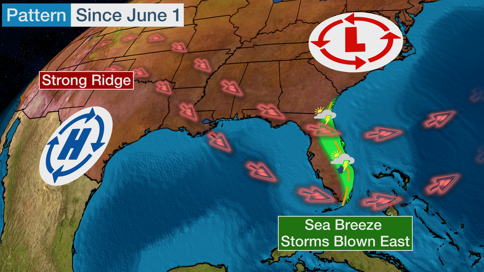
Sea breeze patterns are the star of the rainy season in Florida outside of a tropical storm or hurricane interrupting regularly scheduled business. And that has been the case this year, but instead of alternating coasts from one day to the next, the east coast of Florida has been receiving the wealth of the rainfall so far.
This is due to the location of the domes of high pressure so far, which have been located over Texas or Mexico, or occasionally nudging into the lower Mississippi Valley. Clockwise flow around these heat domes has assisted thunderstorm development along the sea breeze eastward across the state.
 A general look at the pattern since June 1. Interruptions to this pattern have occurred on occasion
Much of northern Florida has also had above normal rainfall recently due to disturbances called ridge riders that have rounded the heat domes from the Plains to the Southeast or East. Many of these disturbances dropped heavy rain in the panhandle and across the northern Gulf Coast.
While intermittent showers have popped up on Florida’s west coast, they’ve remained warm and dry while the east coast has had boomers most afternoons. Many of the ridge riders died out before producing rain on the peninsula.
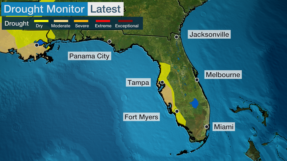
This is so much the fact that a good chunk of the coast is now in severe drought, which is typically eradicated as the rainy season begins.
Only three other years in the last two decades have had severe-level or worse drought conditions.
 U.S. Drought Monitor released July 6
This overall pattern isn’t expected to change any time soon. Outlooks from both The Weather Company/Atmospheric G2 and NOAA’s Climate Prediction Center for July expect warmer than average temperatures.
Weather patterns have led to the warmer and drier conditions in parts of Florida this year, but changes in climate are making warmer summers more likely.
In a recent study from Climate Central, nearly every city that they studied in Florida has seen an increase in extremely hot days. In fact, Tallahassee has seen an extra month of 95-degree days added since 1970.
The Weather Company’s primary journalistic mission is to report on breaking weather news, the environment and the importance of science to our lives. This story does not necessarily represent the position of our parent company, IBM.
The Weather Company’s primary journalistic mission is to report on breaking weather news, the environment and the importance of science to our lives. This story does not necessarily represent the position of our parent company, IBM.

No comments:
Post a Comment